Argyll and Bute is one of 32 unitary council areas in Scotland and a lieutenancy area. The current lord-lieutenant for Argyll and Bute is Jane Margaret MacLeod. The administrative centre for the council area is in Lochgilphead at Kilmory Castle, a 19th-century Gothic Revival building and estate. The current council leader is Councillor Jim Lynch.

Loch Leven is a sea loch located onto the west coast of Scotland. It is spelled Loch Lyon in Timothy Pont's map of the area and is pronounced Li' un. However, the local Gaelic pronunciation is Lee' oon

Ardgour is an area of the Scottish Highlands on the western shore of Loch Linnhe. It lies north of the district of Morvern and east of the district of Sunart. Administratively it is now part of the ward management area of Lochaber, in Highland council area. It forms part of the traditional shire and current registration county of Argyll.

Appin is a coastal district of the Scottish West Highlands bounded to the west by Loch Linnhe, to the south by Loch Creran, to the east by the districts of Benderloch and Lorne, and to the north by Loch Leven. It lies northeast to southwest, and measures 23 by 11 kilometres. The name, meaning "abbey land", in reference to Lismore Abbey, is derived from the Middle Irish apdaine.
Ardchattan and Muckairn is a civil parish within Argyll and Bute in Scotland. It lies north of Oban, bordering Loch Etive and includes Glen Ure, Glen Creran, Barcaldine, Benderloch, Connel, Bonawe and Glen Etive. At the 2001 census, Ardchattan and Muckairn had a population of 2,443, between them. Its name derives from the 6th-century Irish monk Saint Cathan, combined with the Goidelic element ard-, or "heights".

Castle Coeffin is a ruin on the island of Lismore, an island in Loch Linnhe, in Argyll, on the west coast of Scotland. It stands on a promontory on the north-west coast of the island, across Loch Linnhe from Glensanda, at grid reference NM853437.
Eriska is a flat tidal island at the entrance to Loch Creran on the west coast of Scotland.
Shuna Island or simply Shuna is an island in Loch Linnhe, offshore from Appin, in Argyll and Bute, Scotland. The island is approximately two kilometres long and one kilometre wide, and extends to some 155 ha in total. The island is characterised by a table topped hill at its southern end. The name Shuna is probably derived from the Norse, for "sea island". The island is separated from Appin by the Sound of Shuna.

Beinn Sgulaird or Beinn Sguiliaird is a mountain in the Lorn region of the Scottish Highlands, between Glen Creran and Glen Etive. It has a height of 937 m (3074 ft) and is classed as a Munro. The mountain takes the form of a long ridge which runs from southwest to northeast, three kilometres of which lie above 800 m. Hillwalkers commonly traverse the ridge from north to south, as this gives the best views of the Hebrides to the west, in particular the Isle of Mull. While most walkers start from Glen Creran to the west, an ascent from Glen Etive is also possible.
Barcaldine is a small settlement in Scotland centred on the historic Barcaldine House and located on the banks of Loch Creran between Oban and Ballachulish.

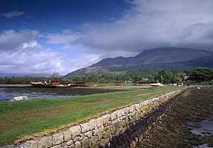
Loch Creran is a sea loch in Argyll and Bute, on the west coast of Scotland. It is about 10 kilometres (6.2 mi) long from its head at Invercreran to its mouth on the Lynn of Lorne, part of Loch Linnhe. The loch separates the areas of Benderloch to the south and Appin to the north. The island of Eriska lies at the mouth of the loch. The loch is bridged at its narrowest point at Creagan, by the A828 road. The village of Barcaldine lies on the south shore of the loch.
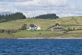
Barcaldine House is a historic mansion in Barcaldine near Oban, Scotland, now a hotel.

Creach Bheinn is a mountain in the Grampian Mountains of Scotland. It rises above the head Loch Creran in Argyll.

The geology of the Isle of Mull in Scotland is dominated by the development during the early Palaeogene period of a ‘volcanic central complex’ associated with the opening of the Atlantic Ocean. The bedrock of the larger part of the island is formed by basalt lava flows ascribed to the Mull Lava Group erupted onto a succession of Mesozoic sedimentary rocks during the Palaeocene epoch. Precambrian and Palaeozoic rocks occur at the island's margins. A number of distinct deposits and features such as raised beaches were formed during the Quaternary period.
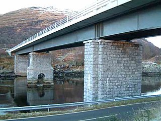
Creagan Bridge is a bridge that crosses Loch Creran at Creagan in Scotland. It is a road bridge that uses the supporting columns of a former railway viaduct.
The River Creran is a river in Argyllshire, Scotland. Its headwaters are on the slopes of Sgùrr na h-Ulaidh. It flows initially generally west through a narrow valley, with several waterfalls, and then generally west then south-west through a broader and flatter valley. Its major tributary, the River Ure, joins it on the left, then it flows through a small loch, Loch Baile Mhic Chalein, and it then reaches a sea loch, Loch Creran. The river's course passes no significant settlements.
This page is based on this
Wikipedia article Text is available under the
CC BY-SA 4.0 license; additional terms may apply.
Images, videos and audio are available under their respective licenses.