Public transport in Istanbul comprises a bus network, various rail systems, funiculars, and maritime services to serve the more than 15 million inhabitants of the city spread over an area of 5,712 km2.
The Istanbul Metro is a rapid transit railway network that serves the city of Istanbul, Turkey. Apart from the M11 line, which is operated by TCDD Taşımacılık, the system is operated by Metro Istanbul, a public enterprise controlled by the Istanbul Metropolitan Municipality. The oldest section of the metro is the M1 line, which opened in 1989. As of April 2023, the system now includes 137 stations in service, with 56 more under construction.

Line M1, officially referred to as the M1 Yenikapı–Atatürk Airport/Kirazlı metro line, also known as the Istanbul Light Metro, is a rapid transit line of the Istanbul Metro. It is colored red on the maps and route signs. Opened in 1989, it was the first rapid transit line in Istanbul and Turkey and its opening started the revival of mass-transit in Turkish cities.

The M2, officially referred to as the M2 Yenikapı–Hacıosman metro line, is a rapid transit line of the Istanbul Metro. It is colored light green on the maps and route signs. The M2 operates between Hacıosman in southern Sarıyer to Yenikapı in south-central Fatih on the historic peninsula of Istanbul. Shuttle trains run from Sanayi to Seyrantepe to Rams Park. The M2 line has 16 stations, all but one underground, and a total length of 23.49 kilometers (14.60 mi). A daily ridership of about 500,000 makes it the busiest line of the Istanbul Metro system.

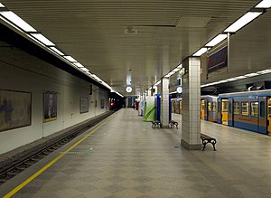
Taksim is an underground rapid transit complex. It is located in central Beyoğlu under Taksim Square in Istanbul. The complex is serviced by the M2 line of the Istanbul Metro and the Kabataş-Taksim Funicular (F1) line. Taksim was opened on 16 September 2000 as the southern terminus of the M2 until the line was extended to Yenikapı in 2014. On 29 June 2006 the Kabataş-Taksim funicular station was opened, offering shuttle service to Kabataş. Taksim is the busiest station on the M2 Line as well as the Istanbul Metro. Connections to Havabüs express bus service to Sabiha Gökçen Airport are available.
Line M6, officially referred to as the M6 Levent – Boğaziçi Üniversitesi/Hisarüstü line, is a 3.3-kilometre (2.1 mi) light metro line of the Istanbul Metro. It is colored tan on the maps and route signs. The line opened for public service on 19 April 2015. Except for the very small Tünel, this line is the shortest of the Istanbul Metro system with only four stations.

Yenikapı Transfer Center, referred to as Yenikapı, is an underground transportation complex in Istanbul. It is located in south-central Fatih in the neighborhood of Yenikapı, hence the name of the hub. The complex is right next to the, indefinitely closed, Yenikapı railway station and a short walk away from the Yenikapı Ferry Terminal and İDO ferry service. Yenikapı complex links two stations of Istanbul Metro to a railway station of the Turkish State Railways on the trans-Bosphorus Marmaray tunnel. Yenikapı is the largest rapid transit station in Turkey.
Emniyet—Fatih is an underground station on the M1 line of the Istanbul Metro. It is located in west-central Fatih under Adnan Menderes Boulevard. Emniyet—Fatih was opened on 3 September 1989 as part of the first rapid transit line in Istanbul and Turkey and is one of the six original stations on the M1 line. The station services several important municipal buildings such as the Istanbul Police Headquarters, Fatih Municipal Building and the Istanbul Tax Offices Directorate.

Topkapı—Ulubatlı is an underground station on the M1 line of the Istanbul Metro. It is located in eastern Fatih between the neighborhoods of Karagümrük and Topkapı in Istanbul. An out-of-system transfer to Vatan station on the T4 light-rail line is available as well as connections to İETT city buses. Topkapı—Ulubatlı was opened on 3 September 1989 as part of the first rapid transit line in Istanbul as well as Turkey and is one of the six original stations of the M1 line. The station is right next to the Byzantine-era Theodosian Walls of Constantinople. The station gets part of its name from the 15th century soldier, Ulubatlı Hasan who was one of the first Ottoman soldiers to scale the walls during the Fall of Constantinople.
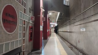
Kirazlı, or Kirazlı-Bağcılar, is an underground rapid transit complex of the Istanbul Metro and is serviced by lines M1B and M3.
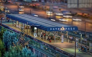
Bayrampaşa—Maltepe is a rapid transit station on the M1 line of the Istanbul Metro. It is located in southern Eyüp, adjacent to the O-3 highway. An out-of-system connection Demirkapı station on the T4 light rail line is available as well as İETT buses.
Sağmalcılar is a rapid transit station on the M1 line of the Istanbul Metro. It is located in central Bayrampaşa, adjacent to the O-3 highway. Sağmalcılar was opened on 3 September 1989 as part of the first rapid transit line in Istanbul as well as Turkey and is one of the six original stations of the M1 line.
Kocatepe is a rapid transit station on the M1 line of the Istanbul Metro. It is located in central Bayrampaşa in the southern part of the neighborhoods Kocatepe. The station is on the north side of the Forum Istanbul Shopping Mall and has direct access to the mall. Kocatepe was opened on 3 September 1989 as part of the first rapid transit line in Istanbul as well as Turkey and is one of the six original stations of the M1 line. The station briefly served as the western terminus of the M1 between September and December 1989 until the line was extended to Esenler.

Otogar is a rapid transit station on the M1 line of the Istanbul Metro. It is located in southwestern Bayrampaşa in the center of the Esenler Bus Terminal.
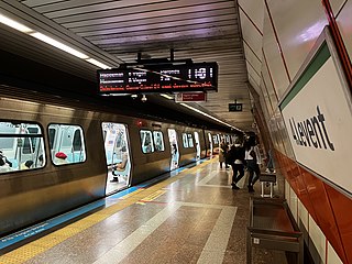
4. Levent is an underground rapid transit station on the M2 line of the Istanbul Metro. It is located in northern Levent under Büyükdere Avenue in Kâğıthane. The station opened on 16 September 2000 and is one of the original six stations of the M2 line. Between 2000 and 2009 4. Levent was the northern terminus of the line and the tracks north of the station would serve as storage tracks for rolling stock. Connections to İETT bus service are available as İETT operates a large bus hub next to the station. The Istanbul Sapphire is situated next to the station and used to be the tallest building in Turkey, standing at a height of 261 m (856 ft). 4. Levent has an island platform serviced by two tracks.
Terazidere is a rapid transit station on the M1 line of the Istanbul Metro located in southern Esenler. It was opened on 31 January 1994 as part of the Otogar-Zeytinburnu extension and is one of the five stations of this extension.

Davutpaşa—YTÜ is a rapid transit station on the M1 line of the Istanbul Metro located in southern Esenler, close to the entrance of Yıldız Technical University or YTÜ. It was opened on 31 January 1994 as part of the Otogar-Zeytinburnu extension and is one of five stations of this extension.
Merter is a rapid transit station on the M1 line of the Istanbul Metro located in southern Güngören. It was opened on 31 January 1994 as part of the Otogar-Zeytinburnu extension and is one of the five stations of this extension.

Bahçelievler is a rapid transit station on the M1 line of the Istanbul Metro located in southeastern Bahçelievler. Connection to the Istanbul Metrobus is available.
Esenler is a rapid transit station on the M1B line of the Istanbul Metro. The station is the on the M1B branch of the M1 line and is the first stop west of where the M1B splits from the M1A. The station is adjacent to the Esenler maintenance facility which was originally built in 1989. Plans to bring passenger service to Esenler existed since the mid-2000s when the station was built, but the municipality wasn't able to see the plans through. Esenler station was opened to the public on 22 February 2012, as part of the new M1B branch that would extend to Kirazlı and connect with the M3.