Al-Chibayish

Last updated
Al-Chibayish

الجبايش
hwr l`rq . ljbysh 15.jpg
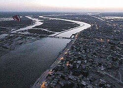
Al-Chibayish from the air
Nickname(s): 
City of the Marshes
Iraq adm location map.svg
Red pog.svg
Al-Chibayish
Coordinates: 30°57′17.7″N46°58′30.3″E / 30.954917°N 46.975083°E / 30.954917; 46.975083 Coordinates: 30°57′17.7″N46°58′30.3″E / 30.954917°N 46.975083°E / 30.954917; 46.975083
CountryFlag of Iraq.svg  Iraq
Governorate Dhi Qar
District Al-Chibayish
Elevation
9 m (30 ft)
Population
 (2014)
  Total36,100 [1]
Time zone UTC+3 (AST)
Area code(s) 01

Al-Chibayish is a town on the Euphrates River in Al-Chibayish District, Dhi Qar governorate, in southern Iraq. It is the capital of its eponymous district.

Al-Chibayish is inhabited primarily by Marsh Arabs of the Beni Isad tribe. Al-Chibayish has historically been an important hub for the Marsh Arab people and a traditional boat-building center for their mashoof canoes. [2]

History

Al-Chibayish was the subject of a groundbreaking 1955 ethnographic study, Marsh Dwellers of the Euphrates Delta, by Iraqi anthropologist Shakir Mustafa Salim. [3]

Al-Chibayish was home to about 11,000 people in 1955. [3] Al-Chibayish's population dropped to less than 6,000 by 2003 as a result of Saddam Hussein's draining of the Mesopotamian Marshes and his associated campaign of violence against the Marsh Arabs, during which Al-Chibayish was attacked by military helicopters. [4] However, the population recovered and quintupled between 2001 and 2009, when it reached an estimated 30,416 people. [1]

Related Research Articles

Geography of Iraq Geographic features of Iraq

The geography of Iraq is diverse and falls into five main regions: the desert, Upper Mesopotamia, the northern highlands of Iraq, Lower Mesopotamia, and the alluvial plain extending from around Tikrit to the Persian Gulf.

Tigris River flowing from Turkey through Iraq and Syria

The Tigris is the eastern of the two great rivers that define Mesopotamia, the other being the Euphrates. The river flows south from the mountains of the Armenian Highlands through the Syrian and Arabian Deserts, and empties into the Persian Gulf.

Baghdad Governorate Governorate of Iraq

Baghdad Governorate, also known as the Baghdad Province, is the capital governorate of Iraq. It includes the capital Baghdad as well as the surrounding metropolitan area. The governorate is the smallest of the 19 provinces of Iraq but the most populous.

Dhi Qar Governorate Governorate of Iraq

Dhi Qar Governorate is a governorate in southern Iraq. The provincial capital is Nasiriyah. Prior to 1976 the governorate was known as Muntafiq Governorate. Dhi Qar was the heartland of the ancient Iraqi civilization of Sumer, and includes the ruins of Ur, Eridu, Lagash, Larsa, Girsu, Umma, and Bad-tibira. The southern area of the governorate is covered by Mesopotamian Marshes.

Tigris–Euphrates river system River system in the Middle East

The Tigris–Euphrates river system is a large river system in Western Asia which discharges into the Persian Gulf. Its principal rivers are the Tigris and Euphrates along with smaller tributaries.

Marsh Arabs

The Marsh Arabs, also referred to as the Maʻdān or shroog —the latter two often considered derogatory in the present day—are inhabitants of the Tigris-Euphrates marshlands in the south of Iraq as well as in the Hawizeh Marshes straddling the Iraq and Iran border.

Al Anbar Governorate Governorate of Iraq

Al Anbar Governorate, or Anbar Province, is the largest governorate in Iraq by area. Encompassing much of the country's western territory, it shares borders with Syria, Jordan, and Saudi Arabia. The provincial capital is Ramadi; other important cities include Ramadi and Falluga.

Musayyib

Musayyib is an increasing majority Shia Arab town in the Babil Province, Iraq. As of 2018, its population was 57,300. Musayyib sits on both the east and west banks of the Euphrates River, which splits into the Hindiya and Hilla branches just south of the city. Musayyib's municipal government has heavy representation from the Office of the Martyr Sadr, the political wing of Moqtada Sadr's Militia. There is a small minority representation by the Badr Corps as well.

Mesopotamian Marshes wetland ecoregion located in southern Iraq and partially in southwestern Iran and Kuwait

The Mesopotamian Marshes, also known as the Iraqi Marshes, are a wetland area located in Southern Iraq and Southwestern Iran. Historically the marshlands, mainly composed of the separate but adjacent Central, Hawizeh and Hammar Marshes, used to be the largest wetland ecosystem of Western Eurasia. It is a rare aquatic landscape in the desert, providing habitat for the Marsh Arabs and important populations of wildlife. Draining of portions of the marshes began in the 1950s and continued through the 1970s to reclaim land for agriculture and oil exploration. However, in the late 1980s and 1990s, during the presidency of Saddam Hussein, this work was expanded and accelerated to evict Shia Muslims from the marshes. Before 2003, the marshes were drained to 10% of their original size. After the fall of Hussein's regime in 2003, the marshes have partially recovered but drought along with upstream dam construction and operation in Turkey, Syria and Iran have hindered the process. Since 2016 the Mesopotamian marshes have been listed as an UNESCO Heritage Site.

Draining of the Mesopotamian Marshes Saddam Husseins campaigns to drain marshes and force population transfer

The draining of the Mesopotamian Marshes occurred in Iraq and to a smaller degree in Iran between the 1950s and 1990s to clear large areas of the marshes in the Tigris-Euphrates river system. Formerly covering an area of around 20,000 km2 (7,700 sq mi), the main sub-marshes, the Hawizeh, Central, and Hammar marshes and all three were drained at different times for different reasons.

Hammar Marshes Marshes in Southern Iraq; a UNESCO World Heritage Site

The Hammar Marshes are a large wetland complex in southeastern Iraq that are part of the Mesopotamian Marshes in the Tigris–Euphrates river system. Historically, the Hammar Marshes extended up to 4,500 km2 (1,700 sq mi) during seasonal floods. They were destroyed during the 1990s by large-scale drainage, dam and dike construction projects. Since 2003, they are recovering following reflooding and destruction of dams.

Amanat Baghdad SC

Amanat Baghdad Sport Club is an Iraqi football team based in Karkh District, Baghdad, Iraq. Formed in 1957 as Amanat Al-Asima, the club has finished runners-up of the 1975–76 Iraq FA Cup.

Hawizeh Marshes

The Hawizeh Marshes are a complex of marshes that straddle the Iraq and Iran border. The marshes are fed by two branches of the Tigris River in Iraq and Karkheh River in Iran. The Hawizeh marsh is critical to the survival of the Central and Hammar marshes, which also make up the Mesopotamian Marshes, because they are a refuge for species that may recolonize or reproduce in the other marshlands. The Hawizeh Marshes are drained by the Al-Kassarah. This river plays a critical role in maintaining the marshes as a flow-through system and preventing it from becoming a closed saline basin.

Shakir Mustafa Salim (1919–1985) was an Iraqi social anthropologist who taught in the Department of Sociology at Baghdad University.

Al-Chibayish District District in Dhi Qar Governorate, Iraq

Al-Chibayish District is a district of the Dhi Qar Governorate, Iraq, located to the east of Nasiriyah and northwest of Basra Governorate. The district capital is Al-Chibayish. The district's geography is dominated by the Hammar Marshes, a subset of the Mesopotamian Marshes, and by the Euphrates River that feeds the marshes.

Al-Hindiya District District in Karbala Governorate, Iraq

Al-Hindiya District is a district of the Karbala Governorate, Iraq. Its largest town is Al-Hindiya, to the east of Karbala. The Hindiya Barrage in the north of the district controls floods and diverts water from the Euphrates into irrigation canals on both sides of the river. The district has been the scene of clashes with Turkish and British colonial forces, and more recently with American troops in 2003. The population is about 230,000, mostly Shia, including significant numbers of refugees. Infrastructure is poor, but efforts are being made to improve it.

Euphrates Region One of seven de facto regions of the Autonomous Administration of North and East Syria

Euphrates Region, formerly Kobanî Canton,, is the central of three original regions of the Autonomous Administration of North and East Syria, comprising Ayn al-Arab District of the Aleppo Governorate, Tell Abyad District of the Raqqa Governorate, and the westernmost tip of the Ras al-Ayn Subdistrict of the Ras al-Ayn District of Al-Hasakah Governorate. Euphrates Region unilaterally declared autonomy in January 2014 and since de facto is under direct democratic government in line with the polyethnic Constitution of Rojava.

Lower Mesopotamia is a historical region of Iraq.

Mashoof

A mashoof, also transliterated mashuf, is a long and narrow canoe traditionally used on the marshes and rivers of southern Iraq. It was widely used by the Marsh Arabs, or Maʻdān (معدان), as a fishing boat, water taxi, and primary means of transportation for people and goods. The mashoof's skinniness makes it an ideal vessel for navigating between the reeds and grasses of the Mesopotamian Marshes.

Al-Barakah is a Syrian administrative district of the Islamic State of Iraq and the Levant (ISIL), a Salafi jihadist militant group and unrecognised proto-state. Originally set up as al-Barakah Province to govern ISIL territories in al-Hasakah Governorate, the province shifted south after 2016 due to the territorial losses to the YPG/YPJ. Having been demoted from province to district in 2018, al-Barakah administered a small strip of land along the Euphrates in Deir ez-Zor Governorate until the Battle of Baghuz Fawqani.

References

  1. 1 2 Brinkhoff, Thomas (July 1, 2015). "IRAQ". citypopulation.de. Retrieved 27 July 2018.
  2. Kubba, Sam (2011). The Iraqi Marshlands and the Marsh Arabs: The Ma'dan, Their Culture and the Environment. Trans Pacific Press. p. 68. ISBN   9780863723339.
  3. 1 2 سليم, شاكر مصطفى (1956). الچبايش: دراسة انثروبوجية لقرية في أهوارالعراق (in Arabic). بغداد: جامعة بغداد.
  4. Mohammad, Ahmed (13 May 2012). "الاهوار: الأهوار ترفض الاندثار وسكانها يتكيّفون مع النزوح الدائم بحثاً عن المياه". جريدة المدى . Retrieved 9 December 2018.