Ala de la Piedra

Last updated
Ala de la Piedra
Barrio
Salto Dona Juana, Orocovis, Puerto Rico.jpg
Salto de Doña Juana in Ala de la Piedra
Ala de la Piedra, Orocovis, Puerto Rico locator map.png
Location of Ala de la Piedra within the municipality of Orocovis shown in red
Caribbean location map.svg
Red pog.svg
Ala de la Piedra
Location of Puerto Rico
Coordinates: 18°10′47″N66°30′38″W / 18.179757°N 66.510465°W / 18.179757; -66.510465 [1]
Commonwealth Flag of Puerto Rico.svg  Puerto Rico
Municipality Flag of Orocovis, Puerto Rico.svg Orocovis
Area
[1]
  Total5.56 sq mi (14.4 km2)
  Land5.51 sq mi (14.3 km2)
  Water0.05 sq mi (0.1 km2)
Elevation
[2]
2,123 ft (647 m)
Population
 (2010)
  Total419
  Density76/sq mi (29/km2)
 Source: 2010 Census
Time zone UTC−4 (AST)

Ala de la Piedra is a barrio in the municipality of Orocovis, Puerto Rico. Its population in 2010 was 419. [3] [4] [5]

Contents

Sectors

Barrios (which are, in contemporary times, roughly comparable to minor civil divisions) [6] in turn are further subdivided into smaller local populated place areas/units called sectores (sectors in English). The types of sectores may vary, from normally sector to urbanización to reparto to barriada to residencial, among others. [7] [8] [9] [10] [11]

The following sectors are in Ala de la Prieta barrio: [12]

Sector Divisoria, Sector Doña Juana, Sector El Frío, Sector El Guineo, and Sector La Torre.

History

Ala de la Piedra was in Spain's gazetteers [13] until Puerto Rico was ceded by Spain in the aftermath of the Spanish–American War under the terms of the Treaty of Paris of 1898 and became an unincorporated territory of the United States. In 1899, the United States Department of War conducted a census of Puerto Rico finding that the combined population of Ala de la Piedra and Orocovis barrios was 1,403. [14]

Historical population
CensusPop.Note
1910 629
1920 88440.5%
1930 1,41460.0%
1940 1,054−25.5%
1950 784−25.6%
1960 587−25.1%
1970 554−5.6%
1980 390−29.6%
1990 44915.1%
2000 418−6.9%
2010 4190.2%
U.S. Decennial Census
1900 (N/A) [15] 1910-1930 [16]
1930-1950 [17] 1980-2000 [18] 2010 [19]

There is a camping site managed by a community center at Ala de la Piedra. [20]

See also

Related Research Articles

<span class="mw-page-title-main">Las Piedras, Puerto Rico</span> Town and municipality in Puerto Rico

Las Piedras, is a town and municipality in east Puerto Rico located in the central eastern region of the island, north of Yabucoa; south of Canóvanas and Río Grande; east of Juncos and San Lorenzo; and west of Naguabo and Humacao. Las Piedras is spread over 7 barrios and Las Piedras Pueblo. It is part of the San Juan-Caguas-Guaynabo Metropolitan Statistical Area.

<span class="mw-page-title-main">Piñas, Toa Alta, Puerto Rico</span> Barrio of Puerto Rico

Piñas is a barrio in the municipality of Toa Alta, Puerto Rico. Its population in 2010 was 1,354.

<span class="mw-page-title-main">Hato Puerco Arriba</span> Barrio of Villalba, Puerto Rico

Hato Puerco is a barrio in the municipality of Villalba, Puerto Rico. Its population in 2010 was 7,728.

<span class="mw-page-title-main">Piedra Gorda, Camuy, Puerto Rico</span> Barrio of Puerto Rico

Piedra Gorda is a barrio in the municipality of Camuy, Puerto Rico. Its population in 2010 was 1,846.

<span class="mw-page-title-main">Orocovis barrio-pueblo</span> Historical and administrative center (seat) of Orocovis, Puerto Rico

Barrio Pueblo is a barrio and the administrative center (seat) of Orocovis, a municipality of Puerto Rico. Its population in 2010 was 682.

<span class="mw-page-title-main">Sabana, Orocovis, Puerto Rico</span> Barrio of Puerto Rico

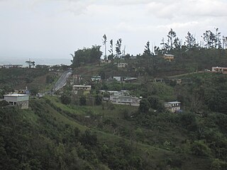
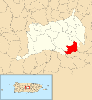
Sabana is a barrio in the municipality of Orocovis, Puerto Rico. Its population in 2010 was 976.

<span class="mw-page-title-main">Perchas, Morovis, Puerto Rico</span> Barrio of Puerto Rico

Perchas is a barrio in the municipality of Morovis, Puerto Rico. Perchas has about 11 sectors and its population in 2010 was 1,336.

<span class="mw-page-title-main">Barros, Orocovis, Puerto Rico</span> Barrio of Puerto Rico

Barros is a barrio in the municipality of Orocovis, Puerto Rico. Its population in 2010 was 1,917.

<span class="mw-page-title-main">Bauta Abajo</span> Barrio of Orocovis, Puerto Rico

Bauta Abajo is a barrio in the municipality of Orocovis, Puerto Rico. Its population in 2010 was 1,516.

<span class="mw-page-title-main">Bermejales</span> Barrio of Orocovis, Puerto Rico

Bermejales is a barrio in the municipality of Orocovis, Puerto Rico. Its population in 2010 was 500.

<span class="mw-page-title-main">Botijas</span> Barrio of Orocovis, Puerto Rico

Botijas is a barrio in the municipality of Orocovis, Puerto Rico. Its population in 2010 was 3,720.

<span class="mw-page-title-main">Damián Arriba</span> Barrio of Orocovis, Puerto Rico

Damián Arriba is a barrio in the municipality of Orocovis, Puerto Rico. Its population in 2010 was 913.

<span class="mw-page-title-main">Gato, Orocovis, Puerto Rico</span> Barrio of Puerto Rico

Gato is a barrio in the municipality of Orocovis, Puerto Rico. Its population in 2010 was 2,072.

<span class="mw-page-title-main">Orocovis, Orocovis, Puerto Rico</span> Barrio of Puerto Rico

Orocovis is a barrio in the municipality of Orocovis, Puerto Rico. Its population in 2010 was 3,658.

<span class="mw-page-title-main">Saltos</span> Barrio of Orocovis, Puerto Rico

Saltos is a barrio in the municipality of Orocovis, Puerto Rico. Its population in 2010 was 3,238.

<span class="mw-page-title-main">Guaniquilla, Aguada, Puerto Rico</span> Barrio of Puerto Rico

Guaniquilla is a coastal barrio in the municipality of Aguada, Puerto Rico. Its population in 2010 was 2,663.

<span class="mw-page-title-main">Lagunas, Aguada, Puerto Rico</span> Barrio of Puerto Rico

Lagunas is a barrio in the municipality of Aguada, Puerto Rico. Its population in 2010 was 2,810.

<span class="mw-page-title-main">Bauta Arriba</span> Barrio of Orocovis, Puerto Rico

Bauta Arriba is a barrio in the municipality of Orocovis, Puerto Rico. Its population in 2010 was 913.

<span class="mw-page-title-main">Cacaos</span> Barrio of Orocovis, Puerto Rico

Cacaos is a barrio in the municipality of Orocovis, Puerto Rico. Its population in 2010 was 878.

<span class="mw-page-title-main">Mata de Cañas</span> Barrio of Orocovis, Puerto Rico

Mata de Cañas is a barrio in the municipality of Orocovis, Puerto Rico. Its population in 2010 was 538.

References

  1. 1 2 "US Gazetteer 2019". US Census. US Government.
  2. U.S. Geological Survey Geographic Names Information System: Ala de la Piedra barrio
  3. Picó, Rafael; Buitrago de Santiago, Zayda; Berrios, Hector H. Nueva geografía de Puerto Rico: física, económica, y social, por Rafael Picó. Con la colaboración de Zayda Buitrago de Santiago y Héctor H. Berrios. San Juan Editorial Universitaria, Universidad de Puerto Rico,1969.
  4. Gwillim Law (20 May 2015). Administrative Subdivisions of Countries: A Comprehensive World Reference, 1900 through 1998. McFarland. p. 300. ISBN   978-1-4766-0447-3 . Retrieved 25 December 2018.
  5. Puerto Rico: 2010 Population and Housing Unit Counts.pdf (PDF). U.S. Dept. of Commerce, Economics and Statistics Administration, U.S. Census Bureau. 2010.
  6. "US Census Barrio-Pueblo definition". factfinder.com. US Census. Archived from the original on 13 May 2017. Retrieved 5 January 2019.
  7. Mari Mut, José A. (28 August 2013). "Los pueblos de Puerto Rico y las iglesias de sus plazas" (in Spanish). Retrieved 19 June 2020 via archive.org.
  8. "Agencia: Oficina del Coordinador General para el Financiamiento Socioeconómico y la Autogestión (Proposed 2016 Budget)". Puerto Rico Budgets (in Spanish). Archived from the original on 28 June 2019. Retrieved 28 June 2019.
  9. Rivera Quintero, Marcia (2014), El vuelo de la esperanza : Proyecto de las Comunidades Especiales Puerto Rico, 1997-2004 (Primera edición ed.), San Juan, Puerto Rico Fundación Sila M. Calderón, ISBN   978-0-9820806-1-0
  10. "Leyes del 2001". Lex Juris Puerto Rico (in Spanish). Archived from the original on 14 September 2018. Retrieved 24 June 2019.
  11. "Comunidades Especiales de Puerto Rico" (in Spanish). 8 August 2011. Archived from the original on 24 June 2019. Retrieved 24 June 2019.
  12. "PRECINTO ELECTORAL Orocovis 066" (PDF). Comisión Estatal de Elecciones (in Spanish). Junta de Planificación - Gobierno de Puerto Rico. 22 September 2020. Retrieved 9 June 2023.
  13. "Anuario del comercio, de la industria, de la magistratura y de la administración. 1881". Biblioteca Nacional de España (in Spanish). p. 1614. Retrieved 4 April 2023.
  14. Joseph Prentiss Sanger; Henry Gannett; Walter Francis Willcox (1900). Informe sobre el censo de Puerto Rico, 1899, United States. War Dept. Porto Rico Census Office (in Spanish). Imprenta del gobierno. p.  165.
  15. "Report of the Census of Porto Rico 1899". War Department Office Director Census of Porto Rico. Archived from the original on July 16, 2017. Retrieved September 21, 2017.
  16. "Table 3-Population of Municipalities: 1930 1920 and 1910" (PDF). United States Census Bureau. Archived (PDF) from the original on August 17, 2017. Retrieved September 21, 2017.
  17. "Table 4-Area and Population of Municipalities Urban and Rural: 1930 to 1950" (PDF). United States Census Bureau. Archived (PDF) from the original on August 30, 2015. Retrieved September 21, 2014.
  18. "Table 2 Population and Housing Units: 1960 to 2000" (PDF). United States Census Bureau. Archived (PDF) from the original on July 24, 2017. Retrieved September 21, 2017.
  19. Puerto Rico: 2010 Population and Housing Unit Counts.pdf (PDF). U.S. Dept. of Commerce Economics and Statistics Administration U.S. Census Bureau. 2010. Archived (PDF) from the original on 2017-02-20. Retrieved 2019-08-02.
  20. "Comunidad Ala de la Piedra Camping Site". Discover Puerto Rico. Retrieved 23 June 2020.