
River Alamut
The Alamut River is a river of northern Iran. It flows through the southern Alborz mountain range into the Shah River. The Taliqan and Alamut rivers conjoin to form the Shahrud River. [1]
The Alamut River is a river of northern Iran. It flows through the southern Alborz mountain range into the Shah River. The Taliqan and Alamut rivers conjoin to form the Shahrud River. [1]
The Alamut River is #1 in the upper right of the map.
| Map of central Alborz | Peaks: | 1 Alam-Kuh |
|---|---|---|
 −25 to 500 m (−82 to 1,640 ft) 500 to 1,500 m (1,600 to 4,900 ft) 1,500 to 2,500 m (4,900 to 8,200 ft) 2,500 to 3,500 m (8,200 to 11,500 ft) 3,500 to 4,500 m (11,500 to 14,800 ft) 4,500 to 5,610 m (14,760 to 18,410 ft) | 2 Azad Kuh | 3 Damavand |
| 4 Do Berar | 5 Do Khaharan | |
| 6 Ghal'eh Gardan | 7 Gorg | |
| 8 Kholeno | 9 Mehr Chal | |
| 10 Mishineh Marg | 11 Naz | |
| 12 Shah Alborz | 13 Sialan | |
| 14 Tochal | 15 Varavašt | |
| Rivers: | 0 | |
| 1 Alamut | 2 Chalus | |
| 3 Do Hezar | 4 Haraz | |
| 5 Jajrood | 6 Karaj | |
| 7 Kojoor | 8 Lar | |
| 9 Noor | 10 Sardab | |
| 11 Seh Hazar | 12 Shahrood | |
| Cities: | 1 Amol | |
| 2 Chalus | 3 Karaj | |
| Other: | D Dizin | |
| E Emamzadeh Hashem | K Kandovan Tunnel | |
| * Latyan Dam | ** Lar Dam |
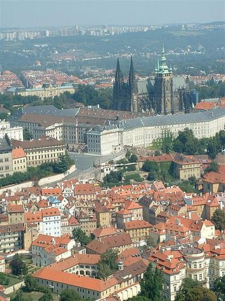
Hradčany, the Castle District, is the district of the city of Prague, Czech Republic surrounding Prague Castle.
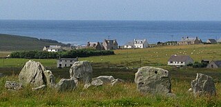
Steinacleit is a prehistoric archeological site on the west coast of Lewis in the Outer Hebrides of Scotland.
Puebla de Sancho Pérez is a municipality in the province of Badajoz, Extremadura, Spain. It has a population of 2,880 and an area of 57 km².
Sheffield Glen is a neighbourhood in Alta Vista Ward in southeast Ottawa, Ontario, Canada. It is bounded on the west by Russell Road, on the south by Walkley Road and on the north and east by Lancaster Road. The neighbourhood is more commonly referred to as Southvale by Ottawans, but appears as Sheffield Glen on maps. Southvale Crescent is the name of the main street which runs through the neighbourhood and is home to a majority of residents. The neighbourhood is home to many apartment buildings and townhouses. Its population according to the Canada 2011 Census was 2877. This decreased to 2,744 according to the Canada 2016 Census.
Tipaza Longwave Transmitter is a Broadcast transmitter of Algeria's Entreprise nationale de Radiodiffusion sonore. It broadcasts the French-speaking station Alger Chaîne 3 on the longwave frequency of 252 kHz. Tipaza Longwave Transmitter, which is situated near Tipaza at 36°33'58" N and 2°28'50" E, has a transmission power of 1500 kW during the day and 750 kW at night. Tipaza Longwave Transmitter antenna is a 355-meter tall guyed mast, which is the second-tallest structure of Algeria.

Ho Tin, named after nearby Ho Tin Street, is an at-grade MTR Light Rail stop located at Kin Fung Circuit, opposite to Tuen Mun River and Tuen Mun station in Tuen Mun District. It began service on 18 September 1988 and belongs to Zone 2. It serves the nearby industrial area.

Shahrood or Shah-Rud, also translated as Shah River, is a river of northern Iran.

The Magech River is a river of Ethiopia. It rises just off the city of Gondar, and flows south into Lake Tana at the latitude and longitude of 12°16′10″N37°23′50″E. Its tributaries include the Dmaza, the Lesser Angereb, and the Ahyamezoriya.

Ovan lake is a small alpine lake in the Alamut region of the Alborz mountain range, in Qazvin province of Iran. The centre point of the lake is approximately located at 36°28′58.98″N50°26′37.39″E. The only tributary that flows into the lake, is a stream with the same name, Ovan, coming down from northern mounts. The north of the lake is surrounded by three small villages, namely from east to west: Varbon, Avan and Zarabad.
Boukram is a town and commune in Bouïra Province, Algeria. According to the 1998 census it has a population of 6,275.

Yozola Glacier is the 5 km long and 1.7 km wide glacier in the Sofia University Mountains situated in the northern portion of Alexander Island in Antarctica, and draining north-northwestwards between Mount Braun and Balan Ridge to flow into Palestrina Glacier.
Ranilović is a village in the municipality of Aranđelovac, Serbia. According to the 2002 census, the village has a population of 1685 people.

Houthaven is a neighbourhood of Amsterdam, Netherlands situated in the West borough. Literally meaning "lumber port", Houthaven is a port situated along the IJ in Amsterdam's western port. It is bordered by a dam in the IJ river to the north and the Spaarndammerbuurt in the south. It is currently predominantly used by inland barges, however plans are in motion to radically change the area in the next few years by building a new residential area on seven artificial islands.

Alamut-e Sharqi District, meaning "East Alamut District", formerly Rudbar-e Alamut District, is a district (bakhsh) in Qazvin County, Qazvin Province, Iran. At the 2006 census, its population was 12,519, in 4,128 families. The District has one city: Moallem Kalayeh. The District has three rural districts (dehestan): Alamut-e Bala Rural District, Alamut-e Pain Rural District, and Moallem Kalayeh Rural District. The majority of people in the district are Tats who speak a dialect of the Tati language. A minority of Azerbaijani people also live in this part.
Juyank is a village in Rudbar-e Mohammad-e Zamani Rural District, Alamut-e Gharbi District, Qazvin County, Qazvin Province, Iran. At the 2006 census, its population was 351, in 90 families.

Alamut is a region in Iran including western and eastern parts in the western edge of the Alborz (Elburz) range, between the dry and barren plain of Qazvin in the south and the densely forested slopes of the Mazandaran province in the north. Starting from Qazvin toward Alamut, passing through the first range of hills, curvatures, forms, are significant themes in nature's composition of this area. The famous Ismaili castle of Alamut and numerous others are in this area, which served as the heartland of the state founded by Hassan-i Sabbah.

Taujėnai Manor is a former residential manor in Taujėnai, Ukmergė district, Lithuania. Currently it is used as a hotel and restaurant.
KJFF is a radio station licensed to Festus, Missouri, United States. The station airs a News-Talk format, and is owned by Alpha Media, through licensee Alpha Media Licensee LLC.
Comet is an unincorporated community in southeast Dade County, in the U.S. state of Missouri. The community lies on the banks of the Sac River, approximately six miles north-northwest of Ash Grove.
Maymūn-Diz was a major fortress of the Nizari Ismailis of the Alamut Period described in historical records. It has been variously identified with the Alamut Castle, Navizar Shah Castle, Shirkuh Castle, Shahrak Castle, and Shams Kalayeh Cave. Recently, Enayatollah Majidi located it on top of Mount Shatan near Khoshk Chal.
| Lake Urmia basin | |
|---|---|
| Persian Gulf basin | |
| Oman sea basin | |
| Caspian basin | |
| Gavkhouni basin | |
| Namak Lake basin | |
| Hamun-e Jaz Murian basin | |
| Other | |
Coordinates: 36°23′50″N50°33′58″E / 36.39722°N 50.56611°E