
The Highveld is the portion of the South African inland plateau which has an altitude above roughly 1500 m, but below 2100 m, thus excluding the Lesotho mountain regions to the south-east of the Highveld. It is home to some of the country's most important commercial farming areas, as well as its largest concentration of metropolitan centres, especially the Gauteng conurbation, which accommodates one-third of South Africa's population.

The Umgeni River or Mgeni River is a river in KwaZulu-Natal, South Africa. It rises in the "Dargle" in the KZN Midlands, and its mouth is at Durban, some distance north of Durban's natural harbour. The name is taken to mean "the river of entrance" in Zulu, though other meanings have been proposed.

A provincial park is a park administered by one of the provinces of a country, as opposed to a national park. They are similar to state parks in other countries. They are typically open to the public for recreation. Their environment may be more or less strictly protected. Argentina, Belgium, Canada and South Africa are among the countries that have provincial parks.
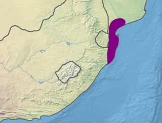
The Maputaland coastal forest mosaic is a subtropical moist broadleaf forest ecoregion on the Indian Ocean coast of Southern Africa. It covers an area of 29,961 square kilometres (11,568 sq mi) in southern Mozambique, Eswatini, and the KwaZulu-Natal Province of South Africa. Mozambique's capital Maputo lies within the ecoregion.
Eastern Cape Parks are the national parks, marine protected areas, nature reserves and other nature conservation areas in the Eastern Cape province of South Africa. Eastern Cape Parks and Tourism Agency (ECPTA) is the governmental organisation responsible for maintaining wilderness areas and public nature reserves in the Eastern Cape, based in East London.
The Mpumalanga Tourism and Parks Agency (MTPA) Board is a governmental organisation responsible for maintaining wilderness areas and public nature reserves in Mpumalanga Province, South Africa.
The North West Parks Board is a governmental organisation responsible for the management of protected areas and public nature reserves in North West Province, South Africa.
Commando Drift Nature Reserve is a nature reserve in Eastern Cape Province, South Africa that is managed by Eastern Cape Parks, the park has an area of 5,827 hectares. The Kommandodrif Dam is included in the reserve.

Oviston Nature Reserve is a protected area in the Eastern Cape Province, South Africa. The nature reserve is managed by Eastern Cape Parks. It is located on the southern shores of the Gariep Dam.
Thomas Baines Nature Reserve is a 1,005-hectare (2,480-acre) nature reserve in Eastern Cape, South Africa that is managed by Eastern Cape Parks. It was created as a municipal reserve in 1961 and upgraded to a provincial reserve in 1980.
Tsolwana Nature Reserve is an 8,500 hectare nature reserve situated on the edge of the Winterberg Mountain range. It is located 60 km west of Queenstown, and 30 km south- east of Tarkastad in Eastern Cape Province, South Africa and is managed by Eastern Cape Parks Board. Its western boundary is formed by the upper Black Kei River. The reserve's name originates from the Xhosa word for "spike", due to the presence of the cone-shaped hill, Spitskop.

Malolotja National Park covers 18,000 hectares of mountain wilderness on Eswatini's northwestern border with South Africa. The park includes Ngwenya Mountain, Eswatini's second highest mountain, and Malolotja Falls which drop 89 metres (292 ft), the highest in Eswatini. Habitats include short grassland to thick riverine scrub, bushveld and Afromontane forest.

Spioenkop Dam Nature Reserve or Spion Kop Nature Reserve is a protected area in KwaZulu-Natal, South Africa. It lies close to Ladysmith with Winterton being the closest town, and is about 4,400 hectares (17 sq mi). The historic battlefield site can be reached by road.

The Mokolo Dam Nature Reserve or Mokolo Dam Provincial Parkis a protected area of bushveld in the Limpopo province, South Africa. It almost surrounds the Mokolo Dam on the Mokolo River. It is located 32 km south of Lephalale, just northeast of the Marakele National Park and not far from the Lapalala Game Reserve.

Bloemhof Dam is a dam in South Africa. It was originally known as the Oppermansdrif Dam when under construction during the late 1960s. It is located at the confluence of the Vaal River and the Vet River, on the border between the provinces North West and Free State. The dam wall has a total length of 4,270 metres (14,010 ft) The reservoir is very shallow, and therefore needs a large area to mean anything for water storage. The area around the reservoir (dam), has been a protected area, but because it lies on the border between provinces, these became two separate nature reserves. On the North West Province side lies the Bloemhof Dam Nature Reserve, on the Free State side is the Sandveld Nature Reserve.
Nwanedi Provincial Park, is a protected area in the northern part of the Limpopo province of South Africa. It is located about 20 km east of Tshipise and 35 km north of Thohoyandou, to the west of Kruger National Park. The Nwanedi park has an area of about 11,170 Ha and includes a part of the wooded foothills of the Soutpansberg Range. The twin dams, the Nwanedi Dam and the Luphephe Dam, at the confluence of the Nwanedi River and its main tributary, the Luphephe River, are located in the protected area. One of the secrets of the Game Reserve is their spectacular waterfall, known as Tshihovhohovho Falls. The park is well stocked with game, including a fair number of white rhino in its lowveld zone.
Gamka is a South African place name and may refer to:
The uMgeni Vlei Nature Reserve in KwaZulu-Natal, South Africa protects several threatened bird species.
