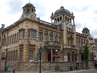
Ilford is a large town in east London, England, 9 miles (14 km) north-east of Charing Cross. Part of the London Borough of Redbridge, Ilford is within the ceremonial county of Greater London. It had a population of 168,168 in 2011, compared to 303,858 for the entire borough.
Wanstead is a town in East London, England, in the London Borough of Redbridge. It borders South Woodford to the north, Redbridge to the east and Forest Gate to the south, with Leytonstone and Walthamstow to the west. It is located 8 miles northeast of Charing Cross.

The London Borough of Redbridge is a London borough established in 1965.
West Hendon is a district of Hendon in North London, in the London Borough of Barnet. It is the NW9 part of Hendon, located around the A5 Edgware Road and the Welsh Harp. The area is known for the West Hendon Estate which is undergoing controversial regeneration.

The London Borough of Redbridge, one of the northern peripheral London boroughs, has within its boundaries parts of two large open spaces: Epping Forest and Wanstead Flats. Apart from many smaller parks, gardens and sports grounds, the following are the main open spaces in Redbridge:

Dartmouth Park is a district of north west London in the Borough of Camden, 6.0 km (3.7 mi) north of Charing Cross. The area adjoins Highgate and Highgate Cemetery and Kentish Town. Parliament Hill is to the west.

Wanstead Flats is the southernmost portion of Epping Forest, in Leytonstone and Wanstead, London. The flats and by extension the forest ends at Forest Gate directly to the south. It now falls wholly within the boundaries of the London Boroughs of Redbridge and Waltham Forest, though until 1994 two parts of it were in the London Borough of Newham: one of these was the section between Aldersbrook Road and Capel Road east of the junction between Aldersbrook Road and St Margaret's Road, whilst the other was the strip running along Capel Road between its junctions with Centre Road and Ridley Road. As part of Epping Forest, the Flats is managed by the City of London Corporation.
Wanstead and Woodford was a constituency in North East London represented in the House of Commons of the Parliament of the United Kingdom. It elected one Member of Parliament (MP) by the first past the post system of election. It existed between 1964 and 1997.

Wanstead Park is a municipal park covering an area of about 140 acres, in Wanstead, in the London Borough of Redbridge. It is also a district of the London Borough of Redbridge, which was in Essex until 1965.

Aldersbrook, is an Edwardian housing estate in Wanstead, East London. It is named after the medieval Manor of Aldersbrook the manor itself was named after the Alders Brook, a minor river which marks part of the boundary between the London Boroughs of Newham and Redbridge.

Woodford is a town in East London, within the London Borough of Redbridge. It is located 9.5 miles (15.3 km) north-east of Charing Cross. Woodford historically formed an ancient parish in the county of Essex. It contained a string of agrarian villages and was part of Epping Forest. From about 1700 onwards, it became a place of residence for affluent people who had business in London; this wealth, together with its elevated position, has led to it being called the Geographical and social high point of East London. Woodford was suburban to London and after being combined with Wanstead in 1934 it was incorporated as a municipal borough in 1937. It has formed part of Greater London since 1965 and comprises the neighbourhoods of Woodford Green, Woodford Bridge, Woodford Wells and South Woodford. The area is served by two stations on the Central line of the London Underground: Woodford and South Woodford.

The Pelham Institute is a former working men's club and multipurpose social venue in the Kemptown area of Brighton, part of the English coastal city of Brighton and Hove. Built in 1877 by prolific local architect Thomas Lainson on behalf of the Vicar of Brighton, the multicoloured brick and tile High Victorian Gothic building catered for the social, educational and spiritual needs of the large working-class population in the east of Brighton. After its closure it hosted a judo club, but is now in residential use as flats owned by a housing association. English Heritage has listed the building at Grade II for its architectural and historical importance.

St. Andrews Square is a mainly 1876 to 1884-built garden square in Surbiton in the borough of Kingston upon Thames, London.

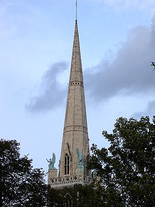
St Mary the Virgin, Wanstead is a Church of England church in Wanstead, east London. It is located on Overton Drive and now shares its parish with Christ Church, Wanstead. It is the only Grade I listed building in the London Borough of Redbridge
The Alders Brook is a small tributary of the River Roding. The name derives from Middle English meaning "brook where alders grow" and is first recorded in 1535; previously it was the site of a farmstead known as Nakethalle or Nagethalle, literally "naked hall", alluding not to a building but to an exposed or unoccupied enclosure. It now marks part of the boundary between the London Boroughs of Newham and Redbridge, with the west bank in the parish of Little Ilford and the east bank in that of Great Ilford. It gave its name to the Aldersbrook area, the Manor of Aldersbrook and the Aldersbrook Estate.

Bushwood is an area in the north of Leytonstone in East London; determined by the curved boundary of the road called Bushwood along the edge of Wanstead Flats, Lister Road to the south and High Road, Leytonstone to the west. The area has the Browning Road Conservation Area, that contains what remains of the historic hamlet of Leyton-atte-stone.

St Gabriel's Church is a Church of England parish church in the Aldersbrook estate area of Wanstead in the London Borough of Redbridge, dedicated to the archangel Gabriel. It began in 1903 as an iron building before a permanent brick church by Charles Spooner in the Perpendicular iteration of the neo-Gothic style was completed in 1914, the same year as St Gabriel's was granted its own parish, taking areas from the parishes of St Mary the Virgin, Wanstead, and St Mary's Church, Little Ilford.
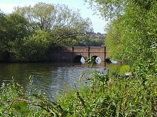
Wanstead Sewage Works, also known as Redbridge (Southern) Sewage Works or Empress Sewage Works, was a municipal sewage treatment works located on a site bounded by the River Roding to the east and Wanstead Park to the north, in the south eastern corner of the parish of Wanstead, in the London Borough of Redbridge, historically within the county of Essex, England. It was in operation from 1 March 1884 to December 1977.
Clapton is a district of East London, England, in the London Borough of Hackney.
