The West Midlands region straddles the historic borders between the counties of Warwickshire, Staffordshire in the north, and Worcestershire in the south.

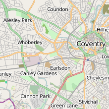
Coventry, a city in the West Midlands, England, grew to become one of the most important cities in England during the Middle Ages due to its booming cloth and textiles trade. The city was noted for its part in the English Civil War, and later became an important industrial city during the 19th and 20th centuries, becoming the centre of the British bicycle and later motor industry. The devastating Blitz in 1940 destroyed much of the city centre, and saw its rebuilding during the 1950s and 60s. The motor industry slumped during the 1970s and 80s, and Coventry saw high unemployment. However, in the new millennium the city, along with many others saw significant urban renaissance and in 2017 it was announced that the city had been awarded the title of 2021 UK City of Culture.
Carnwadric is a residential area of Glasgow, Scotland. It is situated south of the River Clyde, and is bordered by a park to the north, the Arden housing estate to the west, by the village of Thornliebank to the south and by the Auldhouse Burn to the east.

Allesley is a suburban village and civil parish in the City of Coventry metropolitan borough, West Midlands, about 3.5 miles west-northwest of Coventry city centre and 4 miles (6.5 km) east-south-east of Meriden. Located in the Arden area of historic Warwickshire, the parish population according to the 2001 census was 805, which rose to 837 at the 2011 census, and as of the 2021 census, the population was 908. Until 1998, Allesley contained the main Jaguar car assembly plant at Browns Lane.

Stivichall or Styvechale is a suburb of the city of Coventry, in the county of the West Midlands, England. It is a mainly residential area in the south of the city.

Whoberley is a residential suburb of the City of Coventry in the West Midlands, England.

Cliff Vale is a district of the city of Stoke-on-Trent, and lies to the immediate south of Etruria and just east of Basford and Hartshill. Cliffe Vale is in the valley of the Fowlea Brook, now better known as Etruria Valley. There are industrial and employment uses along the A500, and new residential developments along the Trent and Mersey Canal. The Shelton New Road (B5045) passes through from east to west. The area is sometimes called Cliff Vale by the city council, and is part of the Hartshill electoral ward.

Coundon is a predominantly residential suburb in north-west Coventry, in the county of the West Midlands, England.

The city of Davenport, Iowa, United States has neighborhoods dating back to the 1840s. The Davenport Plan and Zoning Commission divided the city into five areas: downtown, central, east end, near north, and northwest and west end. The neighborhoods contain many architectural designs, including Victorian, Queen Anne, and Tudor Revival. Many of the original neighborhoods were first inhabited by German settlers.

Chapelfields is a suburb of Coventry, West Midlands, England. It is situated about 1.5 miles to the west of Coventry City Centre; bordering Coundon to the north, Earlsdon to the south, Spon End to the east and Whoberley to the west. It is mainly residential, with a high proportion of graduates among the younger residents, and nowadays a significant element of students, particularly those studying at the University of Warwick. Houses in Chapelfields proper are mostly small to medium-sized terraced houses with gardens.
Brownshill Green is a suburban hamlet 3.5 miles northwest of Coventry by road, adjacent to the suburbs of Allesley, Coundon and Keresley. It is bordered on its north side by the northern boundary of Coventry and the Warwickshire village of Corley. Its main thoroughfare is Brownshill Green Road, which runs from its junction with Coundon Wedge Drive in the north to join Keresley Road in the south.
Allesley Green is a modern suburb of Coventry in the West Midlands, England, within the civil parish of Allesley.

Weston Coyney is a suburb of the City of Stoke-on-Trent in Staffordshire. It lies on the south eastern edge of the city and borders the neighbouring Staffordshire Moorlands district.
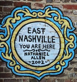
East Nashville is an area east of downtown Nashville in Tennessee across the Cumberland River. The area is mostly residential and mixed-use areas with businesses lining the main boulevards. The main thoroughfares are Gallatin Ave and Ellington Parkway, with smaller arteries interconnecting the neighborhoods. Some of these smaller arteries include Main Street, Shelby Avenue, Porter Road, Riverside Drive, Eastland Avenue, McFerrrin Avenue, and Woodland Street in no significant order. Ellington Parkway, which parallels Gallatin Ave and Main Street, bypasses I-24 and I-65 and connects Briley Parkway and downtown Nashville and many other secondary streets along the way. The Cumberland River confines most of the area with a semicircle design on the south, southwest and east. Since East Nashville has no defined boundaries on the west and north the exact perimeter is the cause of some debate. Some would say that Ellington Parkway creates a boundary on the west and northwest, while Cahal Avenue and Porter Road create the northern boundary, in the confines of zipcode 37206. Many would also state that with I-65 and I-24 as the western border and Briley Parkway as the northern boundary, this defines an area that constitutes Greater East Nashville. East Nashville is one of about 26 suburban neighborhoods in Nashville.

Caludon Castle is a Scheduled Ancient Monument and Grade I listed building in Coventry, in the West Midlands of England. A second moated site 190 metres (620 ft) to the south is a Scheduled Ancient Monument in its own right. The castle is now a ruin, and all that remains is a large fragment of sandstone wall. What remains of the estate is now an urban park, owned and run by Coventry City Council, but much of it was sold and developed into housing estates in the early 20th century.
Castlegate is a historic street in York, England, which leads to York Castle.

Allesley Castle is a former motte and bailey castle in Allesley, Coventry. The mound has never been excavated. All that remains of the castle is a large mound - the motte - and a defensive ditch approximately 45 metres (148 ft) in diameter. The ditch contains several concrete blocks which are thought to be bases for bridges over the motte. The site is a scheduled historical monument.

Trinity House was a small country house in the village of Allesley, Coventry in the West Midlands, formerly the county of Warwickshire. It stood at the end of Rectory Lane immediately north-west of All Saints Church on the crest of the hill between the River Sherbourne and Pickford Brook. The house became one of "the lost houses" of England after being demolished in the mid-1960s as part of the wider destruction of country houses in 20th-century Britain.