Alligator Reef

Last updated

Alligator Reef
USA Florida location map.svg
Red triangle with thick white border.svg
Caribbean location map.svg
Red triangle with thick white border.svg
Alligator Reef (Caribbean)
Location
Location Caribbean
Coordinates 24°50′50″N080°37′11″W / 24.84722°N 80.61972°W / 24.84722; -80.61972
Country United States
Geology
Type reef

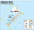
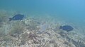
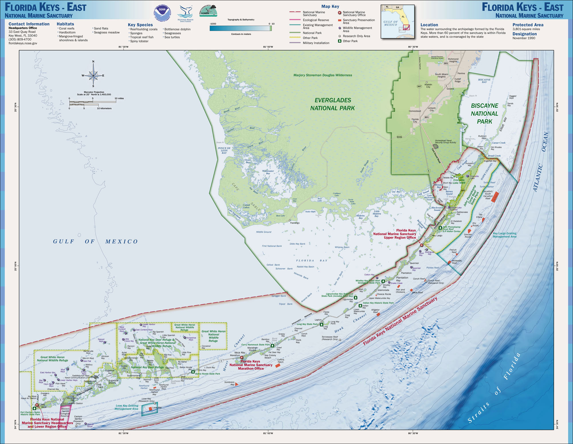
Alligator Reef is a coral reef located within the Florida Keys National Marine Sanctuary. It lies to the southeast of Upper Matecumbe Key. This reef lies within a Sanctuary Preservation Area (SPA).

Contents

Name

Alligator Reef is named for the USS Alligator , a ship assigned to suppress the trade of slaves coming from the African coast in the 1820s. In November 1822, the Alligator was escorting a convoy of merchant ships when she ran aground on the shallow reef. Despite efforts to save the damaged ship, the United States sank her to prevent pirates from pillaging the remains of the boat. [1] The Alligator Reef Light sits on Alligator Reef. A wreck traditionally considered as the remains of USS Alligator is located 200 feet southwest of the lighthouse and can be seen by snorkelers and divers year-round; however a 1996 expedition has challenged this identification, and the wreck is probably that of another 19th c. ship. [2]

Protection

The protected reef is located four nautical miles offshore [3] [4] and is trademarked by the black and white lighthouse present within the reef. Four yellow buoys designate the perimeter of the reef; as anchoring in the SPA is forbidden, there are several buoys in the SPA for mooring boats. [5] Anchoring on the reef is not allowed unless the anchor is fixed to the sandy bottom, as an anchor placed on the reef itself can damage and kill the coral. Tourists venture to the reef daily to relax in the serenity the reef provides. With a variety of aquatic species present, this reef is ideal for beginning snorkelers and divers; some parts of the reef lie at a depth of only eight feet. Many local dive and snorkel boats venture to the reef to provide guided instruction for beginners.

The status of a protected reef restricts any removal of aquatic life. Fishing of any kind is not permitted within the reef and the removal of any coral, sand, shells, or any form of life is prohibited.

See also

Related Research Articles

<span class="mw-page-title-main">Florida Keys National Marine Sanctuary</span> Marine protected area in Florida, US

The Florida Keys National Marine Sanctuary is a U.S. National Marine Sanctuary in the Florida Keys. It includes the Florida Reef, the only barrier coral reef in North America and the third-largest coral barrier reef in the world. It also has extensive mangrove forest and seagrass fields. The Florida Keys National Marine Sanctuary, designated in 1990, is the ninth national marine sanctuary to be established in a system that comprises 13 sanctuaries and two marine national monuments. The Florida Keys National Marine Sanctuary protects approximately 2,900 square nautical miles of coastal and ocean waters from the estuarine waters of south Florida along the Florida Keys archipelago, encompassing more than 1,700 islands, out to the Dry Tortugas National Park, reaching into the Atlantic Ocean, Florida Bay and the Gulf of Mexico.

<span class="mw-page-title-main">John Pennekamp Coral Reef State Park</span> State park at Key Largo, Florida, USA

John Pennekamp Coral Reef State Park is a Florida State Park located on Key Largo in Florida. It includes approximately 70 nautical square miles (240 km²) of adjacent Atlantic Ocean waters. The park is approximately 25 miles in length and extends 3 miles into the Atlantic Ocean. It was the first underwater park in the United States. The park was added to the National Register of Historic Places on April 14, 1972. The primary attractions of the park are the coral reefs and their associated marine life.

<span class="mw-page-title-main">Maritime history of Florida</span> History of waters in and adjacent to Florida

The maritime history of Florida describes significant past events relating to the U.S. state of Florida in areas concerning shipping, shipwrecks, and military installations and lighthouses constructed to protect or aid navigation and development of the Florida peninsula.

San Pedro Underwater Archaeological Preserve State Park is a Florida State Park located in 18 feet (5.5 m) of water, approximately 1.25 nautical miles (2.32 km) south of Indian Key. It became the second Florida Underwater Archaeological Preserve when it opened to the public in 1989. The heart of the park is the San Pedro, a submerged shipwreck from a 1733 Spanish flotilla, around which visitors can dive and snorkel. The San Pedro, a 287-ton Dutch-built vessel, and 21 other Spanish ships under the command of Rodrigo de Torres left Havana, Cuba, on Friday, July 13, 1733, bound for Spain. The San Pedro carried a cargo of 16,000 silver Mexican pesos and crates of Chinese porcelain. A hurricane struck the fleet, while entering the Straits of Florida, and sank or swamped most of the fleet. The wrecksite includes an "eighteenth century anchor, replica cannons, ballast stones encrusted with coral, a dedication plaque, and a mooring buoy system." The wreck was added to the U.S. National Register of Historic Places on May 31, 2001.

<span class="mw-page-title-main">Florida Reef</span> Coral barrier reef along the Florida Keys

The Florida Reef is the only living coral barrier reef in the continental United States. It lies a few miles seaward of the Florida Keys, is about 4 miles wide and extends 270 km (170 mi) from Fowey Rocks just east of Soldier Key to just south of the Marquesas Keys. The barrier reef tract forms a great arc, concentric with the Florida Keys, with the northern end, in Biscayne National Park, oriented north-south and the western end, south of the Marquesas Keys, oriented east-west. The rest of the reef outside Biscayne National Park lies within John Pennekamp Coral Reef State Park and the Florida Keys National Marine Sanctuary. Isolated coral patch reefs occur northward from Biscayne National Park as far north as Stuart, in Martin County. Coral reefs are also found in Dry Tortugas National Park west of the Marquesas Keys. There are more than 6,000 individual reefs in the system. The reefs are 5,000 to 7,000 years old, having developed since sea levels rose following the Wisconsinan glaciation.

<span class="mw-page-title-main">Eastern Dry Rocks</span> Coral reef in the Florida Keys, US

Eastern Dry Rocks is a coral reef located within the Florida Keys National Marine Sanctuary. It lies seven miles southeast of Key West and one mile east of Sand Key light within the Key West National Wildlife Refuge. This reef is within a Sanctuary Preservation Area (SPA).

<span class="mw-page-title-main">Molasses Reef</span> Coral reef located within the Florida Keys National Marine Sanctuary

Molasses Reef is a coral reef located within the Florida Keys National Marine Sanctuary. It lies to the southeast of Key Largo, within the Key Largo Existing Management Area, which is immediately to the east of John Pennekamp Coral Reef State Park. This reef is within a Sanctuary Preservation Area (SPA).

Carysfort is a coral reef located within the Florida Keys National Marine Sanctuary. It lies to the east of Key Largo, within the Key Largo Existing Management Area, which is immediately to the east of John Pennekamp Coral Reef State Park. This reef is within a Sanctuary Preservation Area (SPA). The reef is northeast of The Elbow. The Carysfort Reef Light is near the center of the SPA.

French Reef is a coral reef located within the Florida Keys National Marine Sanctuary. It lies 11 km southeast of Key Largo, within the Key Largo Existing Management Area, which is immediately to the east of John Pennekamp Coral Reef State Park. French Reef is northeast of Molasses Reef. Part of the reef lies within a Sanctuary Preservation Area (SPA), which is 37 ha in area. A number of caves and arches in a spur and groove formation are included in the SPA.

<span class="mw-page-title-main">Pickles Reef</span> Coral reef in the Florida Keys, US

Pickles Reef is a small coral reef located within the Florida Keys National Marine Sanctuary. It lies to the southeast of Key Largo, to the south the Key Largo Existing Management Area and John Pennekamp Coral Reef State Park. Unlike many reefs within the Sanctuary, this reef is not within a Sanctuary Preservation Area (SPA).

Davis Reef is a coral reef located within the Florida Keys National Marine Sanctuary. It lies to the southeast of Plantation Key. This reef lies within a Sanctuary Preservation Area (SPA).

<span class="mw-page-title-main">Rock Key</span>

Rock Key is a coral reef located within the Florida Keys National Marine Sanctuary. It lies to the southwest of Key West, within the Key West National Wildlife Refuge. This reef is within a Sanctuary Preservation Area (SPA).

<span class="mw-page-title-main">Sand Key (reef)</span> Coral reef in the Florida Keys, US

Sand Key is a coral reef located within the Florida Keys National Marine Sanctuary. It lies to the southwest of Key West within the Key West National Wildlife Refuge. This reef is within a Sanctuary Preservation Area (SPA).

9-foot Stake is a coral reef located within the Florida Keys National Marine Sanctuary. It lies to the south of Key West, and is west of Marker 32 reef. Unlike many reefs in the Sanctuary, it is not within a Sanctuary Preservation Area (SPA).

Marker 32 is a coral reef located within the Florida Keys National Marine Sanctuary. It lies to the south of Key West, and is between Western Sambo reef and 9-Foot Stake reef. Unlike many reefs in the Sanctuary, it is not within a Sanctuary Preservation Area (SPA).

<span class="mw-page-title-main">Crocker Reef</span> Coral reef in the Florida Keys, US

Crocker Reef is a coral reef located within the Florida Keys National Marine Sanctuary. It lies to the southeast of Plantation Key, and is near Davis Reef. Unlike many reefs in the Sanctuary, it is not within a Sanctuary Preservation Area (SPA).

Snapper Ledge is a small coral reef located within the Florida Keys National Marine Sanctuary. It lies to the southeast of Key Largo, to the south the Key Largo Existing Management Area and John Pennekamp Coral Reef State Park. Unlike many reefs within the Sanctuary, this reef is not within a Sanctuary Preservation Area (SPA). It is near Pickles Reef. Since 2009, the Coral Restoration Foundation has used Snapper Ledge as a nursery site to grow Elkhorn coral.

<span class="mw-page-title-main">Turtle Reef</span> Coral reef in the Florida Keys, US

Turtle Reef is a coral reef situated at the northern extremity of the Turtle Rocks shoal, and located within the Florida Keys National Marine Sanctuary. It lies to the east of Key Largo, within the Key Largo Existing Management Area, which is immediately to the east of John Pennekamp Coral Reef State Park. Unlike many reefs within the National Marine Sanctuary, this reef is not within a Sanctuary Preservation Area (SPA). The reef is north of Carysfort Reef.

<span class="mw-page-title-main">Molokini</span> Islet in Maui County, Hawaii

Molokini is a crescent-shaped, partially submerged volcanic crater which forms a small, uninhabited islet located in ʻAlalākeiki Channel between the islands of Maui and Kahoʻolawe, within Maui County in Hawaiʻi. It is the remains of one of the seven Pleistocene epoch volcanoes that formed the prehistoric Maui Nui island, during the Quaternary Period of the Cenozoic Era.

<span class="mw-page-title-main">Outline of recreational dive sites</span> Hierarchical outline list of articles about rereational dive sites

Recreational dive sites are specific places that recreational scuba divers go to enjoy the underwater environment or for training purposes. They include technical diving sites beyond the range generally accepted for recreational diving. In this context all diving done for recreational purposes is included. Professional diving tends to be done where the job is, and with the exception of diver training and leading groups of recreational divers, does not generally occur at specific sites chosen for their easy access, pleasant conditions or interesting features.

References

  1. "USS Alligator Shipwreck (U.S. National Park Service)". National Park Service. Retrieved 29 March 2020.
  2. "USS Alligator". Department of the Navy – Naval History & Heritage Command Underwater Archaeology Department. 28 July 2017. Retrieved 9 November 2017.
  3. "The Wreck of the USS Alligator, Florida's Pirate Hunter". Atlas Obscura. Retrieved 29 March 2020.
  4. "Alligator Reef Sanctuary Prreservation Area" . Retrieved 29 March 2020.
  5. "Map of Buoys in Alligator Reef Sanctuary Preservation Area". floridakeys.noaa.gov. Retrieved 29 March 2020.