This article is about the village community. For the geographic parish, former local service district, and rural census subdivision, see Alma Parish, New Brunswick.
The settlement, known as Salmon River Settlement, began in earnest as the lumbering trade took root with the exchange of land-grant title, and construction of a sawmill on the Upper Salmon River by its new owners. Prior to this, Loyalist John Coffin, who held the land grant, caused frustration for would-be settlers because of his absence. Thus began the most vibrant period in the community's history.
Alma's Main Street
The Parish of Alma was created surrounding the community in 1856, commemorating the then-recent Battle of Alma during the Crimean War.[2] The Village municipality incorporated in 1966 following sweeping changes that disbanded county councils. 18 years earlier, the federal government had expropriated land in the village and parish west of the Upper Salmon River for the creation of Fundy National Park. Many homes were relocated east of the river as lumber barons gave way to the new land managers, the Parks Canada Agency. In addition to tourism related to the park, lobster and scallop fishing are an important industry based out of Alma's tidal harbour.[citation needed]
In the 2021 Census of Population conducted by Statistics Canada, Alma had a population of 282 living in 130 of its 196 total private dwellings, a change of 32.4% from its 2016 population of 213. With a land area of 47.64km2 (18.39sqmi), it had a population density of 5.9/km2 (15.3/sqmi) in 2021.[7] Revised census figures based on the 2023 local governance reforms have not been released.
Alma was the birthplace of Molly Kool, who in 1939 became Master Mariner for offshore sailing, a captain, a first in the Western World,[8] sailing a commercial Bay of Fundy scow sloop between ports. A monument on the Alma waterfront marks her accomplishment.
Images
View from Alma Bridge.
The village as viewed from the water
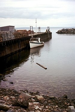
Harbour at high tide.
Harbour at low tide.
Sign at the entrance to the village.
Climate
Alma has a relatively cool, wet and snowy maritime climate with significant seasonal differences in spite of its near-ocean location. Summers are warm but relatively short, whereas winters are relatively cold but milder than inland areas.
↑ NB Deptartment of Environment and local government. Local Governments (LG).kml, January 1, 2023 regulation 2022-50 under the Local Governance Act. [accessed Feb. 9, 2024 via Geonb data catalogue http://www.snb.ca/geonb1/e/dc/LG.asp]
This page is based on this Wikipedia article Text is available under the CC BY-SA 4.0 license; additional terms may apply. Images, videos and audio are available under their respective licenses.