Almont, Michigan

Last updated

Almont, Michigan
Village of Almont
W St Clair St Historic District.jpg
Almont, Michigan location.png
Location within Lapeer County
USA Michigan location map.svg
Red pog.svg
Almont
Location within the state of Michigan
Usa edcp location map.svg
Red pog.svg
Almont
Location within the United States
Coordinates: 42°55′14″N83°02′34″W / 42.92056°N 83.04278°W / 42.92056; -83.04278
CountryUnited States
State Michigan
County Lapeer
Township Almont
Settled1828
Incorporated1855
Government
  Type Village council
  PresidentSteve Schneider
   Clerk Kimberly Keesler
   Manager David Trent
Area
[1]
  Total1.34 sq mi (3.48 km2)
  Land1.34 sq mi (3.48 km2)
  Water0.00 sq mi (0.00 km2)
Elevation
850 ft (259 m)
Population
 (2020)
  Total2,846
  Density2,123.88/sq mi (820.03/km2)
Time zone UTC-5 (Eastern (EST))
  Summer (DST) UTC-4 (EDT)
ZIP code(s)
48003
Area code 810
FIPS code 26-01660 [2]
GNIS feature ID2397941 [3]
Website Official website

Almont is a village in Almont Township, Lapeer County, Michigan. Its population was 2,846 at the 2020 census.

Contents

History

Almont was first settled in 1828 by James Deneen. It received a post office in 1835 named Bristol, for Oliver Bristol, the second permanent settler. The village was platted as Newburg in 1836, and renamed Almont in 1846.

The naming of Almont

According to HildaMae Bowman's "Almont, The Tale of Then and Now," Almont's name was changed in 1845 to honor the Mexican general, Juan Almonte. [4] [5]

Government

Almont is a home rule village with a manager-council form of government. Per its charter the village charter provides for seven councilors elected. Four councilors are up for election every two years, with the top three vote-getters serve three terms while the fourth highest serves two year terms. The president and president pro tempore are selected from its members by the council. A village manager is appointed by the council. [6]

The village is served by specialized governmental units, the Almont Community Schools and the Almont District Library.

Geography

According to the United States Census Bureau, the village has a total area of 1.42 square miles (3.68 km2), all land. [7] The village center of Almont is located at the intersection of M-53 (also known as Van Dyke) and St. Clair Street. To the east, St. Clair is known as Almont Road, and to the west it is known as General Squire Road. In addition, this is also sometimes deemed as "40 Mile Road", although the nearby ascending "mile roads" officially end at "37 Mile Road". Nearby towns include Bruce Township and Romeo to the south; Dryden to the northwest; Imlay City to the north; and Allenton to the east, and Capac to the northeast. Almont is approximately 40 miles (64 km) north of Detroit.

Demographics

Historical population
CensusPop.Note
1880 837
1890 717−14.3%
1900 7180.1%
1910 675−6.0%
1920 78916.9%
1930 8447.0%
1940 9249.5%
1950 1,03512.0%
1960 1,27923.6%
1970 1,63427.8%
1980 1,85713.6%
1990 2,35426.8%
2000 2,80319.1%
2010 2,674−4.6%
2020 2,8466.4%
U.S. Decennial Census [8]

2010 census

As of the census [9] of 2010, there were 2,674 people, 1,030 households, and 728 families living in the village. The population density was 1,883.1 inhabitants per square mile (727.1/km2). There were 1,116 housing units at an average density of 785.9 per square mile (303.4/km2). The racial makeup of the village was 93.1% White, 0.3% African American, 0.3% Native American, 0.2% Asian, 4.9% from other races, and 1.1% from two or more races. Hispanic or Latino of any race were 7.4% of the population.

There were 1,030 households, of which 37.3% had children under the age of 18 living with them, 50.6% were married couples living together, 13.7% had a female householder with no husband present, 6.4% had a male householder with no wife present, and 29.3% were non-families. 25.9% of all households were made up of individuals, and 10.1% had someone living alone who was 65 years of age or older. The average household size was 2.60 and the average family size was 3.11.

The median age in the village was 37.2 years. 26.9% of residents were under the age of 18; 8.1% were between the ages of 18 and 24; 26.9% were from 25 to 44; 26.7% were from 45 to 64; and 11.4% were 65 years of age or older. The gender makeup of the village was 50.2% male and 49.8% female.

2000 census

As of the census [2] of 2000, there were 2,803 people, 1,022 households, and 747 families living in the village. The population density was 1,857.2 inhabitants per square mile (717.1/km2). There were 1,058 housing units at an average density of 701.0 per square mile (270.7/km2). The racial makeup of the village was 95.54% White, 0.32% African American, 0.54% Native American, 0.36% Asian, 2.32% from other races, and 0.93% from two or more races. Hispanic or Latino of any race were 4.14% of the population.

There were 1,022 households, out of which 39.9% had children under the age of 18 living with them, 58.6% were married couples living together, 11.0% had a female householder with no husband present, 26.9% were non-families. 23.0% of all households were made up of individuals, and 8.9% had someone living alone who was 65 years of age or older. The average household size was 2.73 and the average family size was 3.24.

In the village, the population was spread out, with 30.3% under the age of 18, 7.0% from 18 to 24, 33.7% from 25 to 44, 19.7% from 45 to 64, and 9.2% who were 65 years of age or older. The median age was 33 years. For every 100 females, there were 90.9 males. For every 100 females age 18 and over, there were 87.3 males.

The median income for a household in the village was $53,984, and the median income for a family was $63,261. Males had a median income of $50,644 versus $26,667 for females. The per capita income for the village was $21,252. About 4.2% of families and 5.6% of the population were below the poverty line, including 5.8% of those under age 18 and 8.2% of those age 65 or over.

Notable people

Related Research Articles

<span class="mw-page-title-main">Eau Claire, Michigan</span> Village in Michigan, United States

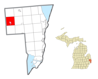
Eau Claire is a village located in east central Berrien County in the U.S. state of Michigan. The population was 552 at the 2020 census.

<span class="mw-page-title-main">Olivet, Michigan</span> City in Michigan, United States

Olivet is a city in Eaton County in the U.S. state of Michigan. The population was 1,605 at the 2010 census. University Of Olivet is located in the city.

<span class="mw-page-title-main">Almont Township, Michigan</span> Civil township in Michigan, United States

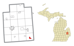
Almont Township is a civil township of Lapeer County in the U.S. state of Michigan. The population was 6,961 at the 2020 Census.

<span class="mw-page-title-main">Dryden Township, Michigan</span> Civil township in Michigan, United States

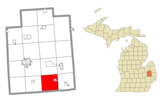
Dryden Township is a civil township in Lapeer County in the U.S. state of Michigan, named in honor of the literary critic, John Dryden. The population was 4,799 at the 2020 census. The village of Dryden is located within the township.

<span class="mw-page-title-main">Onsted, Michigan</span> Village in Michigan, United States

Onsted is a village within Lenawee County in the U.S. state of Michigan. The village had a population of 988 at the 2020 census. Located within the Irish Hills region, the village is part of Cambridge Township.

<span class="mw-page-title-main">Onekama, Michigan</span> Village in Michigan, United States

Onekama is a village in Manistee County in the U.S. state of Michigan. The population was 399 at the 2020 census. The village is located on the northeast shore of Portage Lake and is surrounded by Onekama Township. The town's name is derived from Ona-ga-maa, an Anishinaabe word which means "singing water".

<span class="mw-page-title-main">Scottville, Michigan</span> City in Michigan, United States

Scottville is a city in Mason County in the U.S. state of Michigan. The population was 1,356 at the 2020 census.

<span class="mw-page-title-main">Morley, Michigan</span> Village in Michigan, United States

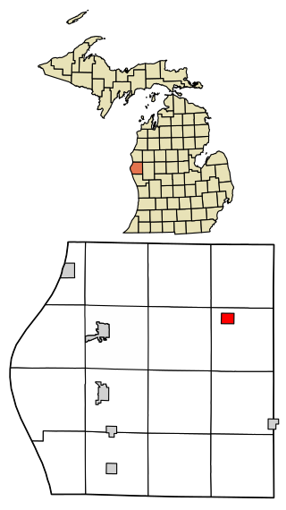
Morley is a village in Mecosta County in the U.S. state of Michigan. The population was 517 at the 2020 census.

<span class="mw-page-title-main">Addison Township, Michigan</span> Civil township in Michigan, United States

Addison Township is a civil township of northeast Oakland County in the U.S. state of Michigan. As of the 2020 census, the township population was 6,256.

<span class="mw-page-title-main">Walkerville, Michigan</span> Village in Michigan, United States

Walkerville is a village in Oceana County of the U.S. state of Michigan. The population was 247 at the 2010 census. The village is located within Leavitt Township.

<span class="mw-page-title-main">Ferrysburg, Michigan</span> City in Michigan, United States

Ferrysburg is a city in Ottawa County in the U.S. state of Michigan. The population was 2,892 at the 2010 census.

<span class="mw-page-title-main">Carsonville, Michigan</span> Village in Michigan, United States

Carsonville is a village in Sanilac County of the U.S. state of Michigan. The population was 527 at the 2010 census. The village is situated at 43°25′37″N82°40′17″W on the boundary between Bridgehampton Township and Washington Township, with about half the village in each.

<span class="mw-page-title-main">Minden City, Michigan</span> Village in Michigan, United States

Minden City is a village in Sanilac County of the U.S. state of Michigan. The population was 197 at the 2010 census. The village is located within Minden Township. It has possessed a post office since 1862.

<span class="mw-page-title-main">Berlin Township, St. Clair County, Michigan</span> Civil township in Michigan, United States

Berlin Township is a civil township of St. Clair County in the U.S. state of Michigan. At the 2020 census, the township population was 3,115.

<span class="mw-page-title-main">Capac, Michigan</span> Village in Michigan, United States

Capac is a village in Mussey Township, St. Clair County in the U.S. state of Michigan. The population was 1,890 at the 2010 census.

<span class="mw-page-title-main">Emmett, Michigan</span> Village in Michigan, United States

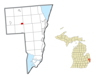
Emmett is a village in St. Clair County of the U.S. state of Michigan. The population was 269 at the 2010 census. The village is located within Emmett Township.

<span class="mw-page-title-main">Mussey Township, Michigan</span> Civil township in Michigan, United States

Mussey Township is a civil township of St. Clair County in the U.S. state of Michigan. The population was 4,234 at the 2020 Census.

<span class="mw-page-title-main">Roscoe, Missouri</span> Village in Missouri, United States

Roscoe is a village in St. Clair County, Missouri, United States. The population was 89 at the 2020 census.

<span class="mw-page-title-main">Almont, North Dakota</span> City in North Dakota, United States

Almont is a city in Morton County, North Dakota, United States. It is part of the "Bismarck, ND Metropolitan Statistical Area" or "Bismarck–Mandan". The population was 100 at the 2020 census. Almont was founded in 1906, incorporated in 1936, and reached a peak population of 232 in 1940. The Northern Pacific Railroad tracks were removed in 1947 when the mainline was rerouted, and the city has since withered to just above 100 residents.

<span class="mw-page-title-main">Zaleski, Ohio</span> Village in Ohio, United States

Zaleski is a village in Vinton County, Ohio, United States. The population was 230 at the 2020 census.

References

  1. "2020 U.S. Gazetteer Files". United States Census Bureau. Retrieved May 21, 2022.
  2. 1 2 "U.S. Census website". United States Census Bureau . Retrieved January 31, 2008.
  3. U.S. Geological Survey Geographic Names Information System: Almont, Michigan
  4. St. Clair County Rootsweb page on old town names
  5. Romig, Walter (1986) [1973]. Michigan Place Names. Detroit, Michigan: Wayne State University Press. ISBN   0-8143-1838-X.
  6. (January 2011). Municipal Report: Organization of City and Village Government in Michigan Archived August 30, 2016, at the Wayback Machine . Updated. Michigan Municipal League. Accessed on February 15, 2016.
  7. "US Gazetteer files 2010". United States Census Bureau. Archived from the original on January 25, 2012. Retrieved November 25, 2012.
  8. "Census of Population and Housing". Census.gov. Retrieved June 4, 2015.
  9. "U.S. Census website". United States Census Bureau . Retrieved November 25, 2012.

Sources