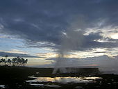
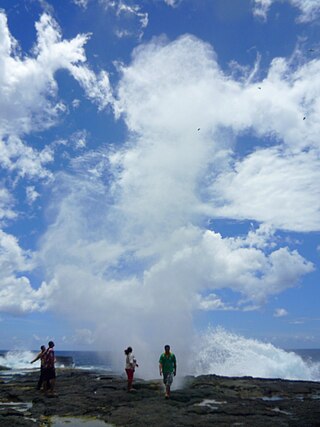
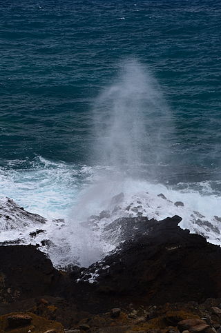
The Alofaaga Blowholes, also known as the Taga Blowholes, are a natural feature located in the district of Palauli, south west of Salelologa wharf on the island of Savai'i in Samoa. The entrance to the blowholes is in the village of Taga. [1]
In this area, lava flows have created a series of tubes connecting a flat clifftop of lava rock with the ocean below. Waves breaking against the lower end of the lava tubes send water at high pressure up through the tubes, creating fountains that spray every few seconds. [2] As most of the land in Samoa is under customary ownership, the village charges a small admission for entry to view the blowholes. The area is unfenced and surrounded by wet, slippery rocks which can be dangerous. Falling into one of the blowholes would be almost certainly fatal. A track along the coast can be followed west to the ancient village of Fagaloa. [1]


A stalactite is a mineral formation that hangs from the ceiling of caves, hot springs, or man-made structures such as bridges and mines. Any material that is soluble and that can be deposited as a colloid, or is in suspension, or is capable of being melted, may form a stalactite. Stalactites may be composed of lava, minerals, mud, peat, pitch, sand, sinter, and amberat. A stalactite is not necessarily a speleothem, though speleothems are the most common form of stalactite because of the abundance of limestone caves.

Savaiʻi is the largest and highest island both in Samoa and in the Samoan Islands chain. The island is also the sixth largest in Polynesia, behind the three main islands of New Zealand and the Hawaiian Islands of Hawaii and Maui. While it is larger than the second main island, Upolu, it is significantly less populated.

In geology, a blowhole or marine geyser is formed as sea caves grow landward and upward into vertical shafts and expose themselves toward the surface, which can result in hydraulic compression of seawater that is released through a port from the top of the blowhole. The geometry of the cave and blowhole along with tide levels and swell conditions determine the height of the spray.

Falealupo is a village in Samoa situated at the west end of Savai'i island 20 miles (32 km) from the International Date Line used until 29 December 2011. The village has two main settlements, Falealupo-Uta, situated inland by the main island highway and Falealupo-Tai, situated by the sea. The road to the coastal settlement is about 9 km, most of it unsealed, from the main highway. The village's population is 545.
El Malpais National Monument is a National Monument located in western New Mexico, in the Southwestern United States. The name El Malpais is from the Spanish term Malpaís, meaning badlands, due to the extremely barren and dramatic volcanic field that covers much of the park's area.

Gagaʻemauga is a district on the island of Savaiʻi in Samoa. The district is situated on the central north side of Savaiʻi. The name 'Gagaʻemauga' literally means "near side of the mountain", meaning the eastern side of the mountain chain running through the centre of Savaiʻi Island.
Gagaʻifomauga is a political district on the island of Savaiʻi in Samoa. The district is situated on the northern side of the island with a population of 4,878.
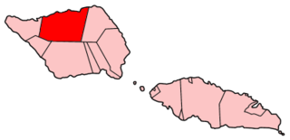
Palauli is a district and village of Samoa, with a population of 9,300. It consists of two sections on the southern side of Savai'i. The capital is Vailoa which is also referred to as Vailoa i Palauli.
Hālona Blowhole is a rock formation and a blowhole on the island of Oahu, Hawaii off of Hanauma Bay at Hālona Point overlooking the Pacific Ocean. In Hawaiian hālona means "lookout".

Taga is a village on the island of Savai'i in Samoa. It is situated on the south coast of the island in the district of Palauli and the electoral district of Palauli 1. The population is 785.
Aopo is a village in the Gaga'ifomauga district on the island of Savai'i in Samoa. It is situated inland in the central north of the island in the district of Gagaʻifomauga and the electoral district of Gagaʻifomauga 3. The population is 383. The name of the village is derived from two words, ao (day) and po (night) and may be derived from a volcanic eruption.
ʻAmanave is a village on the coast of Tutuila Island, American Samoa. It is located close to the island's western tip, Cape Taputapu, and to the south of the village of Poloa. It is located in Lealataua County.
Safa'i is a village on the north central coast of Savai'i island in Samoa. The village is part of the electoral constituency Gaga'emauga 2 which forms part of the larger political district Gaga'emauga.

The Falemauga Caves are large natural caverns in a series of lava-tunnels situated in the Tuamasaga district along the central ridge of Upolu island in Samoa. The caves have been studied by archaeologists in Samoa with evidence of human occupation in pre-history. They were also used as a place of refuge by the people of Tuamasaga.

Lunar lava tubes are lava tubes on the Moon formed during the eruption of basaltic lava flows. When the surface of a lava flow cools, it hardens and the lava can channel beneath the surface in a tube-shaped passage. Once the flow of lava diminishes, the tube may drain, forming a hollow void. Lunar lava tubes are formed on sloped surfaces that range in angle from 0.4° to 6.5°. These tubes may be as wide as 500 metres (1,600 ft) before they become unstable against gravitational collapse. However, stable tubes may still be disrupted by seismic events or meteoroid bombardment.

Spouting Horn is a blowhole located on the southern coast of Kauai in the Koloa district. This area of Kauai is known for its crashing waves. These waves erode lava rocks on the coastline which can create narrow openings, as is the case with Spouting Horn. With every wave, water shoots upward when it is forced through an opening and creates a sound suggestive of hissing. The spray can shoot as high as 50 feet in the air. The original Hawaiian name was puhi, meaning blowhole. The Spouting Horn is a part of the Koloa Heritage Trail, a 10-mile trail in the Koloa district.

Martian lava tubes are volcanic caverns on Mars that are believed to form as a result of fast-moving, basaltic lava flows associated with shield volcanism. Lava tubes usually form when the external surface of the lava channels cools more quickly and forms a hardened crust over subsurface lava flows. The flow eventually ceases and drains out of the tube, leaving a conduit-shaped void space which is usually several meters below the surface. Lava tubes are typically associated with extremely fluid pahoehoe lava. Gravity on mars is about 38% that of Earth's, allowing Martian lava tubes to be much larger in comparison.

The Pancake Rocks and Blowholes are a coastal rock formation at Punakaiki on the West Coast of the South Island of New Zealand. They are a popular visitor attraction.
An anchialine system is a landlocked body of water with a subterranean connection to the ocean. Depending on its formation, these systems can exist in one of two primary forms: pools or caves. The primary differentiating characteristics between pools and caves is the availability of light; cave systems are generally aphotic while pools are euphotic. The difference in light availability has a large influence on the biology of a given system. Anchialine systems are a feature of coastal aquifers which are density stratified, with water near the surface being fresh or brackish, and saline water intruding from the coast at depth. Depending on the site, it is sometimes possible to access the deeper saline water directly in the anchialine pool, or sometimes it may be accessible by cave diving.
13°48′08″S172°31′11″W / 13.8022°S 172.5197°W
| | This article about a geographical location in Samoa is a stub. You can help Wikipedia by expanding it. |