Cumulonimbus rising above the Black Mountains (North Carolina).
Mountain thunderstorms pose significant risks because of their consequences, especially for mountaineers, hikers and paragliders. Despite monitoring weather conditions to prevent accidents, disasters occurring during such phenomena often remain unpredictable and are the subject of novels or other stories.
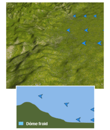
Formation of a cold front when the air in an uplift is stable or can not reach the top of the obstacle. The air is forced over the front and causes the formation of a low level jet stream .
Thunderstorms are formed when air in a layer of the atmosphere is unstable.[1] A parcel of air raised at the base of this layer is then warmer than the environment and rises. In rising, its temperature decreases by adiabatic expansion, and when the relative humidity of water vapor reaches saturation, this forms a convective cloud.[1] To form a storm, this layer must be very large and the temperature at the top of the cloud must be below −20C.
direct lifting at the level of free convection in unstable air, lifting with a synoptic wind that arrives w/ a component perpendicular to the slopes. The air is forced up the slope and into convection;
thermal forcing in an unstable situation where there is weak general circulation and diurnal warming. The mountain breezes then generate anabatic winds which also rise.
dynamic forcing when air is stable lower down, and circulation is blocked by the mountain, but the air is unstable at higher altitude. In this case general circulation is forced above this blocking layer and can reach the convective layer.
In a more general case, several effects may be present and if the synoptic wind is opposed to the anabatic wind, additional convergence occurs at the top of the mountain.[3] It is also possible to create a convergence zone behind the mountain when the synoptic wind can divide and go around it to meet again (ex. Puget Sound Convergence Zone ) that will promote convection.[2]
The uprising serves to not only destabilize the air and form convective clouds, but also to enhance its intensity.[1] As the rising air from the bottom of the slopes is hotter and humid than the surrounding air, the lifted index will be more negative, increasing the vertical extension of the cloud . A simple temperature difference of 2C is enough to greatly aggravate the violence of thunderstorms.
Special phenomena
Mountain storms have particularities because of the proximity of clouds, the importance of electric fields, their rapidity of appearance, their particular danger. Sudden wind lift of a mass of air can radically change the initial conditions within them.
Observable phenomena give an idea of the peculiarities of mountain storms .
Mountaineers are the most exposed to these phenomena,[4] in ridges and pass passes.
In addition to the common phenomena related to the storm, larger electric fields cause unexpected warning signs related to the ionization of the air.[5] French mountaineers say they hear "bees": suddenly, on all surfaces, are small noisy discharges.[6][7] After this bee-sound, another observation is that the hair stands straight up over the head, and sparks can form between the teeth when one opens one's mouth. These are the results of electrical phenomena, already described in other situations, and known by the name of fire of St. Elmo or corona effect also called crown effect.[8]
Climbers, not very mobile, can find themselves trapped in a storm. The metal ice axes of climbing equipment can attract lightning, a great danger in these situations.
The force of thunder, lightning, lightning, rain, hail, bursts and whirlwinds can cause other dangerous situations. Some natural phenomena are increased tenfold by altitude,[9] in particular:
Weather forecasting is an essential tool for preventing accidents related to mountain storms[10] but does not prevent them. Climbers must know how to respond to a storm in the mountains.[11]
Premier de cordée (First on the Rope) by Roger Frison-Roche touched on the spectacle of mountain climbing and the experience of high mountain guides in these extreme situations. It was adapted to the cinema in a 1944 film by Louis Daquin with Maurice Baquet; and to a television movie in 1999, directed by Pierre-Antoine Hiroz and Edouard Niermans.
Autobiographies
Walter Bonatti in 1965
A number of mountaineers in the 20th century wrote autobiographical accounts of being caught in mountain storms.
The Conquerors of the useless by Lionel Terray: Surprised during the ascent of Mount Maudit, the author writes "At the beginning of the afternoon, as we approached the summit, the storm burst on us, sparks of sparks were formed above the pompons of our hats and I felt again the panic fear provoked in me by these outbursts of nature. "
The famous British climber Chris Bonington said: "I have often bivouacked to wait for the good weather, spent nights in the storm ... In a storm, there is nothing to do but sit, wait for it to pass... ".[15]
Montagne pour un homme nu[16] (Mountain for a naked man), by Pierre Mazeaud. This book reports the tragedy on Mont Blanc on July 11, 1961, where seven mountaineers were surprised by a violent storm on the pillar of Frêney, near the summit of Mont Blanc. One hundred and ten hours later, a helicopter landed three survivors at Courmayeur; among them Walter Bonatti[17] and Mazeaud.[18]
About the 1961 disaster, Mazeaud wrote: "Sitting on my stirrups, I use my piton, when I hear a striking ring somewhat resembling the phone. My companions, forty meters below, prick up their ears. Soon, I feel pain in my fingers, sparks run on my hammer. The carabiners on my shoulder stick to my fingers (...) A pendulum swing puts me near Pierrot, when a flash of a surprising glow hits him in the face, exactly in the ear where his hearing aid blackens. He falls into my arms, haggard, disgusted, without reaction". He also noted that Pierre Kohlmann[19] was not killed instantly but the shock seemed to make him lose his mind. During the several days that it took to descend, he did not say a word, finally collapsing just before reaching the entrance, the last victim of the storm that killed four mountaineers.[20]
Thillet, Jean-Jacques; Schueller, Dominique (2009). Petit manuel de météo montagne. Topo guides. Glénat. p.192. ISBN978-2723463195.
Cotton, William R; Bryan, George H; van den Heever, Susan C (2011). Storm and Cloud Dynamics. International geophysics series. Vol.99 (Seconded.). Academic Press. p.807. ISBN978-0-12-0885428.
Further reading
Dominique Musto (2014). Parapente Vol de distance. Éditions du Chemin des Crêtes. p.208. ISBN9-782953-919141. Musto.
Lionel Terray, The Conquerors of the Useless, Paulsen Edition, coll. Guerin, 458 p., Illustrated and enriched with 450 photos and drawings for the most part unpublished ISBN2911755197
Related Research Articles
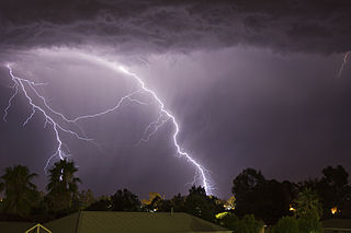
A thunderstorm, also known as an electrical storm or a lightning storm, is a storm characterized by the presence of lightning and its acoustic effect on the Earth's atmosphere, known as thunder. Relatively weak thunderstorms are sometimes called thundershowers. Thunderstorms occur in a type of cloud known as a cumulonimbus. They are usually accompanied by strong winds and often produce heavy rain and sometimes snow, sleet, or hail, but some thunderstorms produce little precipitation or no precipitation at all. Thunderstorms may line up in a series or become a rainband, known as a squall line. Strong or severe thunderstorms include some of the most dangerous weather phenomena, including large hail, strong winds, and tornadoes. Some of the most persistent severe thunderstorms, known as supercells, rotate as do cyclones. While most thunderstorms move with the mean wind flow through the layer of the troposphere that they occupy, vertical wind shear sometimes causes a deviation in their course at a right angle to the wind shear direction.
A meteorologist is a scientist who studies and works in the field of meteorology aiming to understand or predict Earth's atmospheric phenomena including the weather. Those who study meteorological phenomena are meteorologists in research, while those using mathematical models and knowledge to prepare daily weather forecasts are called weather forecasters or operational meteorologists.
A mesocyclone is a meso-gamma mesoscale region of rotation (vortex), typically around 2 to 6 mi in diameter, most often noticed on radar within thunderstorms. In the northern hemisphere it is usually located in the right rear flank of a supercell, or often on the eastern, or leading, flank of a high-precipitation variety of supercell. The area overlaid by a mesocyclone’s circulation may be several miles (km) wide, but substantially larger than any tornado that may develop within it, and it is within mesocyclones that intense tornadoes form.
Walter Bonatti was an Italian mountaineer, alpinist, explorer and journalist. He was noted for many climbing achievements, including a solo climb of a new alpine climbing route on the south-west pillar of the Aiguille du Dru in August 1955, the first ascent of Gasherbrum IV in 1958, and, in 1965, the first solo climb in winter of the North face of the Matterhorn on the mountain's centenary year of its first ascent. Immediately after his solo climb on the Matterhorn, Bonatti announced his retirement from professional climbing at the age of 35, and after 17 years of climbing activity. He authored many mountaineering books and spent the remainder of his career travelling off the beaten track as a reporter for the Italian magazine Epoca. He died on 13 September 2011 of pancreatic cancer in Rome aged 81, and was survived by his life partner, the actress Rossana Podestà.
Atmospheric convection is the result of a parcel-environment instability in the atmosphere. Different lapse rates within dry and moist air masses lead to instability. Mixing of air during the day expands the height of the planetary boundary layer, leading to increased winds, cumulus cloud development, and decreased surface dew points. Convection involving moist air masses leads to thunderstorm development, which is often responsible for severe weather throughout the world. Special threats from thunderstorms include hail, downbursts, and tornadoes.
A storm cell is an air mass that contains up and down drafts in convective loops and that moves and reacts as a single entity, functioning as the smallest unit of a storm-producing system. An organized grouping of thunder clouds will thus be considered as a series of storm cells with their up/downdrafts being independent or interfering one with the other.
A dry thunderstorm is a thunderstorm that produces thunder and lightning, but where all or most of its precipitation evaporates before reaching the ground. Dry lightning refers to lightning strikes occurring in this situation. Both are so common in the American West that they are sometimes used interchangeably.
A mesovortex is a small-scale rotational feature found in a convective storm, such as a quasi-linear convective system, a supercell, or the eyewall of a tropical cyclone. Mesovortices range in diameter from tens of miles to a mile or less and can be immensely intense.
Catherine Destivelle is a French rock climber and mountaineer who is considered one of the greatest and most important female climbers in the history of the sport. She came to prominence in the mid-1980s for sport climbing by winning the first major female climbing competitions, and by being the first female to redpoint a 7c+/8a sport climbing route with Fleur de Rocaille in 1985, and an 8a+ (5.13c) route with Choucas in 1988. During this period, she was considered the strongest female sport climber in the world along with Lynn Hill, however, in 1990 she retired to focus on alpine climbing.
Nicolas Jaeger was a French physician, alpinist, and ski mountaineer.
The Spanish Plume is a weather pattern in which a plume of warm air moves from the Iberian plateau or the Sahara to northwestern Europe, causing thunderstorms. This meteorological pattern can lead to extreme high temperatures and intense rainfall during the summer months, with potential for flash flooding, damaging hail, and tornado formation. Some of these intense thunderstorms are formed from thermal lows, which are also known as heat lows. Thermal lows can be semipermanent features around some parts of Europe, particularly in the summer season. These thermal lows can be developed or created around Spain, Portugal, France, etc., during the summer season because of the intense heat. Thermal low pressure can be located around the world, particularly in the summer or in tropical regions.
The following is a glossary of tornado terms. It includes scientific as well as selected informal terminology.
Numerous aviation accidents have occurred in the vicinity of thunderstorms due to the density of clouds. It is often said that the turbulence can be extreme enough inside a cumulonimbus to tear an aircraft into pieces, and even strong enough to hold a skydiver. However, this kind of accident is relatively rare. Moreover, the turbulence under a thunderstorm can be non-existent and is usually no more than moderate. Most thunderstorm-related crashes occur due to a stall close to the ground when the pilot gets caught by surprise by a thunderstorm-induced wind shift. Moreover, aircraft damage caused by thunderstorms is rarely in the form of structural failure due to turbulence but is typically less severe and the consequence of secondary effects of thunderstorms.
The 2018–19 South-West Indian Ocean cyclone season was the costliest and the most active season ever recorded. Additionally, it is also the deadliest cyclone season recorded in the South-West Indian Ocean, surpassing the 1891–92 season in which the 1892 Mauritius cyclone devastated the island of Mauritius, and is mainly due to Cyclone Idai. The season was an event of the annual cycle of tropical cyclone and subtropical cyclone formation in the South-West Indian Ocean basin. It officially began on 15 November 2018, and ended on 30 April 2019, except for Mauritius and the Seychelles, which it ended on 15 May 2019. These dates conventionally delimit the period of each year when most tropical and subtropical cyclones form in the basin, which is west of 90°E and south of the Equator. Tropical and subtropical cyclones in this basin are monitored by the Regional Specialised Meteorological Centre in Réunion.
This glossary of meteorology is a list of terms and concepts relevant to meteorology and atmospheric science, their sub-disciplines, and related fields.
The 2019–20 South-West Indian Ocean cyclone season was a slightly above-average season in tropical cyclone and subtropical cyclone formation west of 90°E. The season officially began on 15 November, however, the formation of the first system—Zone of Disturbed Weather 01—occurred on 22 July 2019, well before the official start of the season. This was the earliest start to a season since the 2016–17 season. The season then officially ended on 30 April 2020, with the exception of Mauritius and the Seychelles, for which it officially ended on 15 May 2020. These dates conventionally delimit the period of each year when most tropical and subtropical cyclones form in the basin, which is west of 90°E and south of the Equator. Tropical and subtropical cyclones in this basin are monitored by the Regional Specialized Meteorological Centre in Réunion.
The 2020–21 South-West Indian Ocean cyclone season was an above-average season which produced 12 named storms, with 7 strengthening into tropical cyclones. The season started with the formation of Cyclone Alicia in the extreme northeast section of the basin on 12 November 2020, just before the official start of the season, which marked the third season in a row in which a tropical cyclone formed before the official start of the season. It officially began on 15 November 2020, and ended with the dissipation of Cyclone Jobo on 24 April, 6 days before the official end on 30 April 2021, with the exception of Mauritius and the Seychelles, which officially ended on 15 May 2021. These dates conventionally delimit the period of each year when most tropical and subtropical cyclones form in the basin, which is west of 90°E and south of the Equator. Tropical and subtropical cyclones in this basin are monitored by the Regional Specialised Meteorological Centre in Réunion and unofficially by the Joint Typhoon Warning Center.
Severe Tropical Storm Eliakim was a tropical cyclone that affected Madagascar and killed 21 people in 2018. The seventh tropical depression, sixth tropical storm of the 2017–18 South-West Indian Ocean cyclone season, and fourth tropical cyclone in 2018 to impact Madagascar, Eliakim was first noted as an area of atmospheric convection south-southwest of Diego Garcia on 9 March. Developmental conditions were favorable in its vicinity, and on 14 March, both the Joint Typhoon Warning Center (JTWC) and Météo-France La Réunion (MFR) began issuing warnings on the system, with MFR designating it as Tropical Disturbance 7 and the JTWC giving it the designation 14S. On the next day, MFR upgraded the system to a moderate tropical storm, assigning it the name Eliakim. Eliakim further intensified into a severe tropical storm on 15 March, with the JTWC upgrading it to a Category 1-equivalent cyclone on the Saffir–Simpson scale on 16 March. Eliakim made landfall on Masoala at 07:00 UTC, after which MFR estimated maximum 10-minute sustained winds of 110 km/h (70 mph) within the system. Eliakim weakened into a moderate tropical storm before abruptly turning southwards and re-emerging over water on 17 March. Despite unfavorable conditions, Eliakim re-intensified into a severe tropical storm on 19 March before being downgraded back into a moderate tropical storm 6 hours later. Eliakim transitioned into a post-tropical cyclone on 20 March as it moved away from Madagascar, with the MFR last tracking the system on 22 March.
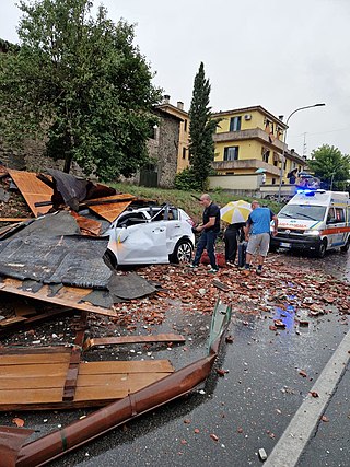
The 2022 European derecho was a violent derecho which resulted in strong winds on the French island of Corsica and in parts of northern Italy, Austria, Slovenia, and the southern Czech Republic on 18 August 2022 which traveled over 1,000 kilometres (620 mi). The event resulted in 12 fatalities, and at least 116 others were injured.
This page is based on this Wikipedia article Text is available under the CC BY-SA 4.0 license; additional terms may apply. Images, videos and audio are available under their respective licenses.