Alsta

Last updated
Alsta
Sju sostre in Alsta, 06 2011.jpg
Norway - Alsten.png
Norway Nordland adm location map.svg
Red pog.svg
Alsta
Location of the island
Norway location map.svg
Red pog.svg
Alsta
Alsta (Norway)
Geography
Location Nordland, Norway
Coordinates 65°54′31″N12°25′53″E / 65.9087°N 12.4314°E / 65.9087; 12.4314 Coordinates: 65°54′31″N12°25′53″E / 65.9087°N 12.4314°E / 65.9087; 12.4314
Area152.6 km2 (58.9 sq mi)
Length30 km (19 mi)
Width8 km (5 mi)
Highest elevation1,072 m (3517 ft)
Highest pointBotnkrona
Administration
Norway
County Nordland
Municipalities Alstahaug and Leirfjord
Demographics
Population6,969 (2017)

Alsta (historically, Alsten or Alstein) [1] [2] is an island in the municipalities of Alstahaug and Leirfjord in Nordland county, Norway. The island is surrounded by the Vefsnfjorden to the east, the Leirfjorden to the north, and the Alstenfjorden to the south and west. The eastern part of the island is dominated by the Seven Sisters mountain range which has five mountains that are more than 1,000 metres (3,300 ft) tall, while the western part of the island is relatively flat and it is the location of the town of Sandnessjøen and the village of Søvika in the south.

Lowland near the Seven Sisters mountains Alsten.jpg
Lowland near the Seven Sisters mountains

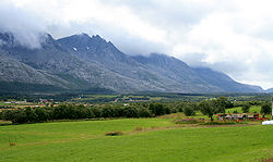
The 30-kilometre (19 mi) long island has an area of 152.6 square kilometres (58.9 sq mi), and its highest point is the mountain Botnkrona, which reaches 1,072 metres (3,517 ft) above sea level. In 2017, there were 6,969 residents on the island. [2] The islands of Altra and Skålvær lie to the southwest, the islands of Tjøtta, Offersøya, Mindlandet, and Rødøya lie to the south, surrounding the entrance to the Vefsnfjorden.

The island is connected to the mainland by the Helgeland Bridge on Norwegian County Road 17, which connects the northern part of the island to the municipality of Leirfjord on the mainland. This same highway 17 continues across the island from north to south where it then connects by bridge to the nearby islands of Offersøya and Tjøtta.

The eastern part of the island is often called the "backside" of the island since it is on the other side of the mountains from the more populous side. This "backside" lies inside the municipality of Leirfjord and the Sundøy Bridge connects the Sundøy village area on the backside of the island to the mainland. [2]

See also

Related Research Articles

Alstahaug Municipality in Nordland, Norway

Alstahaug is a municipality in Nordland county, Norway. It is part of the Helgeland region. The administrative centre of the municipality is the town of Sandnessjøen. Some of the villages in Alstahaug include Søvika and Tjøtta.

Leirfjord Municipality in Nordland, Norway

Leirfjord is a municipality in Nordland county, Norway. It is part of the Helgeland traditional region. The administrative centre of the municipality is the village of Leland. Other villages in Leirfjord include Bardalssjøen and Sundøy. The large Helgeland Bridge is partly located in the municipality, connecting it to Alstahaug Municipality and the town of Sandnessjøen.

Sundøy Village in Northern Norway, Norway

Sundøy or Sundøya is a village in the municipality of Leirfjord in Nordland county, Norway. The village is located about 5 kilometres (3.1 mi) south of the village of Leland. Sundøya has a population of about 120 people. It is located on the north side of the Vefsnfjorden on the northeastern part of the island of Alsta, east of the Seven Sisters mountains, which isolate it from the rest of the island. Since Sundøy is surrounded by mountains and water, it was only accessible by boat until 2003 when the Sundøy Bridge was built, providing a road connection to the mainland of Leirfjord.

Helgeland Bridge

The Helgeland Bridge is a cable-stayed bridge that crosses the Leirfjorden between the mainland and the island of Alsta in Nordland county, Norway. The town of Sandnessjøen is located just southwest of the bridge on the island.

Sundøy Bridge

The Sundøy Bridge is a cantilever bridge in the municipality of Leirfjord in Nordland county, Norway. The concrete bridge connects the mainland to the village of Sundøy on the island of Alsta. The 538-metre (1,765 ft) bridge has three spans, with the main span being 298 metres (978 ft) long. The maximum clearance to the sea is 43.5 metres (143 ft).

Ofotfjord

Ofotfjord is a fjord in Nordland county, Norway. It is an inlet of the Norwegian Sea, located about 200 kilometres (120 mi) north of the Arctic Circle. The 78-kilometre (48 mi) long Ofotfjord is Norway's 12th longest fjord and it is also the 18th deepest, with a maximum depth of 553 metres (1,814 ft). In the English language and in many historical documents, this fjord is often referred to as the Narvik Fjord because the town of Narvik is located on the inner shores of the fjord, but this is not an official name of the fjord.

Vefsnfjord

The Vefsnfjord or Vefsnfjorden is a fjord in the Helgeland traditional district of Nordland county, Norway. It is about 51 kilometres (32 mi) long, reaching a maximum depth of about 440 metres (1,440 ft) below sea level. The fjord flows through the municipalities of Alstahaug, Leirfjord, and Vefsn.

Godøya

Godøya or Godøy is an island in Giske Municipality in Møre og Romsdal county, Norway. The island is famous for its beautiful nature, dominated by the 497-metre (1,631 ft) tall mountain Storhornet and the large lake Alnesvatnet.

Stamnes, Nordland Former municipality in Nordland, Norway

Sandnessjøen or Stamnes is a former municipality in Nordland county, Norway. The 45-square-kilometre (17 sq mi) municipality existed from 1899 until its dissolution in 1965. The municipality encompassed the northern part of the island of Alsten in what is now Alstahaug Municipality. Originally, it (briefly) also included all of what is now Leirfjord Municipality as well. The administrative centre of the municipality was the town of Sandnessjøen.

Tysnesøy

Tysnesøya or Tysnesøy is an island in Tysnes municipality in Vestland county, Norway. The 198-square-kilometre (76 sq mi) island makes up the vast majority of the island municipality of Tysnes. The tallest point on the island is the 753-metre (2,470 ft) tall mountain Tysnessåto.

Bremangerlandet

Bremangerlandet is an island in Bremanger Municipality in the traditional district of Nordfjord in Vestland county, Norway. The 153-square-kilometre (59 sq mi) island is one of the largest islands in the county. The highest point on the island is the 889-metre (2,917 ft) tall mountain Svartevassegga, however the cliff at Hornelen, located 1 kilometre (0.62 mi) to the east, is more well-known and has an elevation of 860 metres (2,820 ft). The 4-kilometre (2.5 mi) long lake Dalevatnet is located in the central part of the island.

Holsnøy

Holsnøy is an island in Alver Municipality in Vestland county, Norway. The 88.8-square-kilometre (34.3 sq mi) island lies to the north/west of the mainland, between the islands of Radøy to the north and Askøy to the south. The highest point on the island is the 324-metre (1,063 ft) tall Eldsfjellet, a mountain located about 2 kilometres (1.2 mi) north of the village of Rossland. The island is hilly and marshy, with the majority of the residents living along the southern shore. The largest settlement on the island is the village of Frekhaug on the southern shore.

Leinøya

Leinøya is an island in the municipality of Herøy in Møre og Romsdal county, Norway. Its original name was Bølandet, but Leinøya is now the official name. The island is located east of the town of Fosnavåg on the nearby island of Bergsøya. The island is connected to several surrounding islands via a network of bridges. The Remøy Bridge connects it to the island Remøya, the Herøy Bridge connects it to Nautøya and Gurskøya, and a small bridge connects to the island of Bergsøya.

Tjøtta (island)

Tjøtta is an island in Alstahaug Municipality in Nordland county, Norway. The 11.3-square-kilometre (4.4 sq mi) island lies at the entrance to the Vefsnfjorden, just south of the island of Alsta. The U-shaped island is relatively flat, and the highest point is the 77-metre (253 ft) tall Kalvberghaugen, just east of the village of Tjøtta. The island has two main villages on it: Tjøtta and Svinnes. The Norwegian County Road 17 crosses the island and it connects it to the neighboring islands of Offersøya and Alsta by two causeways.

Leirfjorden

Leirfjorden is a fjord in the municipalities of Leirfjord and Alstahaug in Nordland county, Norway. The 20-kilometre (12 mi) long fjord is located east of the town of Sandnessjøen, between the mainland and the island of Alsta. There is a short strait that connects it to the Vefsnfjorden to the south.

Tjøtta (municipality) Former municipality in Nordland, Norway

Tjøtta is a former municipality in Nordland county, Norway. The 326-square-kilometre (126 sq mi) municipality existed from 1862 until its dissolution in 1965. The municipality was centered around the island of Tjøtta plus the mainland to the east and south as well as over 3000 islands, islets, and skerries to the west. The administrative centre of Tjøtta was the village of Tjøtta, located on the island of Tjøtta, where the Tjøtta Church is located.

Vega (island in Norway)

Vega is an island in Vega Municipality in Nordland county, Norway. The 108-square-kilometre (42 sq mi) island is the largest island in the 6,500 islands in the Vegaøyan archipelago, all of which is a UNESCO World Heritage Site. The island lies in the Norwegian Sea, about 18 kilometres (11 mi) west of the mainland of Norway. The islands of Igerøya and Ylvingen lie between Vega and the mainland. The main villages on the island are Gladstad, the administrative centre of the municipality, and Holand.

Mindlandet

Mindlandet is an island in Alstahaug Municipality in Nordland county, Norway. The 13.8-square-kilometre (5.3 sq mi) island lies at the mouth of the Vefsnfjorden, just south of the islands of Tjøtta and Rødøya. The island is fairly flat, and has a lot of very good agricultural land.

Offersøya

Offersøya or Offersøy is an island in Alstahaug Municipality in Nordland county, Norway. The 6.7-square-kilometre (2.6 sq mi) island lies directly between the large island of Alsta and the smaller island of Tjøtta at the mouth of the Vefsnfjorden. The Norwegian County Road 17 runs across the island connecting Alsta and Tjøtta. The island is relatively flat, with the highest point only reaching 43 metres (141 ft) above sea level. In 2016, there were 61 residents living on the island.

Rødøya, Alstahaug

Rødøya or Røøya is an island in Alstahaug Municipality in Nordland county, Norway. The 7.3-square-kilometre (2.8 sq mi) island lies at the mouth of the Vefsnfjorden and the Halsfjorden. The island is home to 23 people, living mostly on the southern part of the island.

References

  1. "Stadnamn og skrivemåten for stadnamn" (in Norwegian). Kartverket. Retrieved 2019-02-23.
  2. 1 2 3 Thorsnæs, Geir, ed. (2018-11-14). "Alsta". Store norske leksikon (in Norwegian). Kunnskapsforlaget . Retrieved 2019-02-23.