
Alpine tundra is a type of natural region or biome that does not contain trees because it is at high elevation, with an associated harsh climate. As the latitude of a location approaches the poles, the threshold elevation for alpine tundra gets lower until it reaches sea level, and alpine tundra merges with polar tundra.

The Tawan Bogd is a mountain massif in Mongolia, near the triple border with China and Russia. Its highest peak, the Khüiten Peak, is the highest point of Mongolia at 4374 meters above sea level.

The Scandinavian montane birch forests and grasslands is defined by the World Wildlife Fund (WWF) as a terrestrial tundra ecoregion in Norway, Sweden, and Finland.

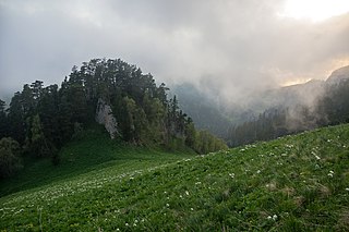
Katun Nature Reserve is a Russian zapovednik located in the highlands of the central Altai Mountains of south Siberia. The Katun River runs down through a valley in the reserve, serving as the primary source of the Ob River. The headwaters of the Katun River originate on Mount Belukha, the highest mountain in Siberia at 4,506 metres (14,783 ft), which is located on the far eastern edge of the preserve. Katun is an internationally important center of biodiversity, forming part of the "Golden Mountains of Altai" UNESCO World Heritage Site. Katun Nature Reserve is situated in the Ust-Koksinsky District of Altai Republic.

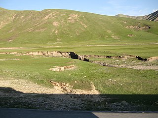
Saylyugemsky National Park sits at the mountainous "X" where the borders of Russia, Kazakhstan, Mongolia and China meet in the Altai Mountains of central Asia. Because of its remoteness and position at the meeting points of mountains, steppes, desert and forest, it is a globally important natural reserve for biodiversity. The park was formally established in 2010–2012, with a particular purpose of protecting the vulnerable Altai argali mountain sheep and the endangered Snow leopard. The component Saylyugem Mountains are a ridge of the Altai, and stretch to the northeast to the Sayan Mountains. The climate is cold and semi-arid. Administratively, the park is located in the Kosh-Agachsky District of the Altai Republic. While ecotourism has a stated role, visits to the territory currently require special passes from park administration, and activities are limited to roads and trails.

Azas Nature Reserve is a Russian 'Zapovednik', located in the central part of the Todzha basin of south-central Asia about 500 km west of Lake Baikal. The reserve stretches along the Azas River, and is situated in the Todzhinsky District of Tuva.

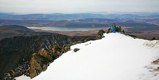
Kabardino-Balkarski Nature Reserve is a Russian 'zapovednik' on main ridge of the north Caucasus Mountains. It contains all of the mountains in Europe over 5,000 meters besides Mt. Elbrus and Mt. Kazbek, and contains the most glaciers. The ridge at the reserve forms the famous "Bezengi wall" consisting of the peaks Gestola, Katyn-Tau, Janga, Eastern Jangi-Tau and Shkhara. There are 256 glaciers in the reserve's boundaries. The reserve is situated in the Chereksky District of Kabardino-Balkar Republic; it was created in 1976, and covers an area of 82,507 ha (318.56 sq mi).
Caucasus Nature Reserve is a Russian zapovednik covering a heavily mountainous section of the Northwest Caucasus Mountains. It is the largest and oldest in the territory of specially protected natural area in the Caucasus, having been created in 1924 as the Caucasian Bison Reserve. In 1979, the site was named a UNESCO Biosphere Reserve, and in 1999 included in a UNESCO World Heritage Site. In 2008 it was officially renamed after Khachatur (Christopher) G. Shaposhnikova the biologist who founded the reserve. The area is situated in the Mostovsky District of Krasnodar Krai, covering an area of 280,335 ha (1,082.38 sq mi).

Kuznetsk Alatau Nature Reserve is a Russian 'zapovednik' on the Kuznetsk Alatau, a mountain ridge in the Altai-Sayan mountain region in southwestern Siberia. The Kuznetsk Alatau consists of several ranges of medium height, between which there are river valleys. The reserve is in the watershed of the Tom River and the Chuly River. It is spread over three districts of Kemerovo Oblast: Tisulsky District, Mezhdurechensky District, and Novokuznetsky District. The reserve was established in 1989 and covers an area of 412,900 ha (1,594 sq mi).

Katon-Karagay National Park is the largest national park in Kazakhstan, located on the eastern edge of the country, in the Southern Altai Mountains. The park fills the west side of the "X" where the borders of Kazakhstan, Russia, China, and Mongolia meet. The highest peak in Siberia, is on the Russian border in the Katun Range. The park is in Katonkaragay District of East Kazakhstan Region, 1,000 kilometres (620 mi) southeast of the capital city of Astana.

The Altai montane forest and forest steppe ecoregion covers patches of the subalpine forest belt on the Altai Mountains, crossing the border region where Russia, Kazakhstan, Mongolia and China meet. The region has high biodiversity, as it is located in transition zones between different ecoregions, altitudes, and climate zones. It is in the Palearctic realm, with a Cold semi-arid climate. It covers 35,199,998 km2 (13,590,795 sq mi).

The Sayan montane conifer forests ecoregion covers the mid-elevation levels of the Sayan Mountains, the high mountain range between the taiga of Siberia, Russia to the north, and the steppes of Mongolia to the south. The slopes of the mountains at the mid-altitudes are covered by Temperate coniferous forest. The ecoregion is in the Palearctic realm, with a cold semi-arid climate. It covers 35,741,835 km2 (13,800,000 sq mi).

The Sayan Alpine meadows and tundra ecoregion is an ecoregion that covers the high areas of the Sayan Mountains above the treeline, between the Altai Mountains in the west and Lake Baikal in the east. The area is remote and protects diverse species of alpine flora and fauna. It has an area of 846,149 square kilometres (326,700 sq mi).

The Cherskii–Kolyma mountain tundra ecoregion is an ecoregion that covers the higher elevations of the Chersky Range and the Kolyma Mountains, the only large mountain range in northern Russia. It is in the Palearctic realm, and tundra biome. It has an area of 556,589 square kilometres (214,900 sq mi).
The Central Tibetan Plateau alpine steppe ecoregion covers the high alpine plateau that stretches over 1,600 kilometres (1,000 mi) across the Tibetan Plateau to Qinghai Lake in China. Because of the high altitude—much it over 5,000 metres (16,000 ft)—the region is a cold, arid desert that is only 20% covered with steppe and meadow vegetation. The area has been relatively free from human development due to the hostile climate and unsuitability for agriculture. The ecosystem is relatively intact, and supports herds of wild antelope, sheep, deer, and gazelles.
The Khangai Mountains alpine meadows ecoregion runs along the central ridge of the Khangai Mountains in central Mongolia. The slopes to the north are conifer forests, the lowlands to the south are semi-arid steppe. The Khangai are an "island" mountain range surrounded by lower forest steppe and semi-arid regions of central Mongolia. Most of the region is now protected by Tarvagatai Nuruu National Park and Khangai Nuruu National Park.

Ikh Bogd Uul National Park is centered on Ikh Bogd, the highest mountain in the Altai-Gobi Mountains, a southeastern spur range of the Altai. The middle and high elevations feature alpine meadows and montane steppe. The range, with semi-arid deserts to the north and south, supports rare species, such as the near-threatened argali and Pallas's cat.


