Alverthorpe

Last updated

Alverthorpe
Alverthorpe Wakefield - geograph.org.uk - 31072.jpg
Batley Road
West Yorkshire UK location map.svg
Red pog.svg
Alverthorpe
Location within West Yorkshire
OS grid reference SE310215
Metropolitan borough
Metropolitan county
Region
Country England
Sovereign state United Kingdom
Post town WAKEFIELD
Postcode district WF2
Police West Yorkshire
Fire West Yorkshire
Ambulance Yorkshire
List of places
UK
England
Yorkshire
53°41′21″N1°31′51″W / 53.6893°N 1.5308°W / 53.6893; -1.5308

Alverthorpe is a suburb of, and former village in Wakefield, West Yorkshire, England.

Contents

History

After the start of the Industrial Revolution woollen and worsted yarns were spun and woollen and worsted cloth woven in the mills and factories that were built in the valley. Rope and twine were also manufactured. [1]

In 1830 the township's population was 4,590 and in 1870 it had 1,423 houses and the population had risen to 6,645. [2]

A. Talbot & Sons manufactured sweets for many years in a factory with a landmark chimney which was originally a rag mill.[ citation needed ] The company originated in 1890, selling wholesale groceries from a horse-drawn vehicle, but moved into boiled sweet manufacture when its sweet supplier, John Kay of Flushdyke, retired and gave it his recipes. [3] The company's humbugs, mint imperials, toffees and Yorkshire mixtures became popular throughout Yorkshire and further afield. [4] The Talbots ran the business until the mid-1960s, when it was sold to Victory V lozenges. [3]

In the early 20th century, rhubarb was grown in the surrounding area, the region known as the Rhubarb Triangle. Forcing sheds were surrounded by fields of rhubarb plants. [5]

Governance

Alverthorpe and Thornes was anciently a township which included Westgate Common, Flanshaw, Kirkhamgate and Silcoates in the ecclesiastical parish of Wakefield in the wapentake of Agbrigg and Morley in the West Riding of Yorkshire. [1] The town hall was in Green Lane, and it had a workhouse off Light Lane, as well as its own sewage farm and slaughterhouse. [6]

After the passing of the Poor Law Amendment Act of 1834, Alverthorpe became one of the 17 constituent parishes of the Wakefield Poor Law Union formed in 1837. [7]

Geography

Alverthorpe is 1.5 miles (2.4 km) north west of Wakefield in the valley of the Alverthorpe Beck which supplied water for the mills. The underlying rocks are the coal measures of the South Yorkshire Coalfield. [1]

Much of the meadowland between Alverthorpe and the neighbouring village of Wrenthorpe is a designated Local Nature Reserve, comprising 52 acres (25 ha). [8]

Economy

Bective Mills, which now produces Sirdar hand knitting and rug wool, was established in Alverthorpe over 200 years ago. The company's 1791 Hebble Mill was replaced after being destroyed by fire in 1905. [3] Thomas and Henry Harrap developed the business as Messrs Harrap Bros. Ltd. from 1880 onwards and the buildings and equipment continued to be upgraded and extended throughout the twentieth century. [3] Now operating as Sirdar Spinning Ltd, [9] the mill is one of Britain's foremost worsted spinning mills for hand knitting wool. [10]

Transport

The village is located on the road from Wakefield to Batley. It lies just over a kilometre north of the A638 road from Wakefield to Dewsbury, which intersects with the M1 motorway (at junction 40), about 5 km from Alverthorpe.

A railway line ran through the village, and Alverthorpe railway station, close to the village centre, was opened in October 1872 by the Great Northern Railway. In 1923 it became part of the London and North Eastern Railway. The line passed to the Eastern Region of British Railways on nationalisation in 1948 and closed in April 1954. The railway, bridges and embankments have all now been removed.

Education

Silcoates School was founded in 1830 as the Northern Congregational School. [1]

St Paul's CofE Junior and Infant school is situated in Alverthorpe, with Mr Lee Swift as the current headteacher. [11]

Religious sites

The stone built Anglican church of St Paul stands at the top of a hill, north of the village. It is a Commissioners' Church built in 1826 [12] to accommodate 1,590 worshippers, at a cost of £7,828 16s. 8d, [13] (based on increases in average earnings, this would be approximately £6,352,000 in 2016). [14] The graveyard on the south, north and west sides of the church is specifically for church burials; there was a Local Authority graveyard to the south. [15]

There was a Methodist chapel in the centre of the village, but the building is now used for business purposes. A Presbyterian congregation met in a disused malt kiln in Flanshaw Lane from 1672, but moved to a new chapel in 1697 which combined the Flanshaw and Wakefield congregations, this later becoming the Westgate Unitarian Chapel. A Presbyterian burial ground with over a hundred graves remained in the village until the tombstones were removed around 1905 and the ground was used for market gardening. [3]

Notable people

See also

Related Research Articles

<span class="mw-page-title-main">West Yorkshire</span> County of England

West Yorkshire is a ceremonial county in the Yorkshire and the Humber region of England. It borders North Yorkshire to the north and east, South Yorkshire and Derbyshire to the south, Greater Manchester to the south-west, and Lancashire to the west. The city of Leeds is the largest settlement.

<span class="mw-page-title-main">Wakefield</span> City in West Yorkshire, England

Wakefield is a cathedral city in West Yorkshire, England located on the River Calder. The city had a population of 109,766 in the 2021 census, up from 99,251 in the 2011 census. The city is the administrative centre of the wider metropolitan district, which had a 2021 population of 353,802, the 25th most populous district in England. It is part of the West Yorkshire Built-up Area and the Yorkshire and The Humber region.

<span class="mw-page-title-main">Ossett</span> Town in West Yorkshire, England

Ossett is a market town in West Yorkshire, England, within the City of Wakefield. Historically part of the West Riding of Yorkshire, it is situated between Dewsbury, Horbury and Wakefield. At the 2021 census, the town had a population of 21,861. Ossett forms part of the Heavy Woollen District.

<span class="mw-page-title-main">Rothwell, West Yorkshire</span> Market Town in West Yorkshire, England

Rothwell is a town in the south-east of the City of Leeds metropolitan borough in West Yorkshire, England. It is situated between Leeds and Wakefield.

<span class="mw-page-title-main">Armley</span> Human settlement in England

Armley is a district in the west of Leeds, West Yorkshire, England. It starts less than 1 mile (1.6 km) from Leeds city centre. Like much of Leeds, Armley grew in the Industrial Revolution and had several mills, one of which now houses the Leeds Industrial Museum at Armley Mills. Armley is predominantly and historically a largely working class area of the city, still retains many smaller industrial businesses, and has many rows of back-to-back terraced houses.

<span class="mw-page-title-main">Horbury</span> Town in West Yorkshire, England

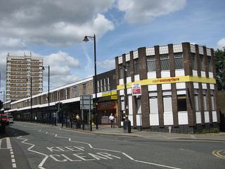
Horbury is a town in the City of Wakefield in West Yorkshire, England. Historically in the West Riding of Yorkshire, it is situated north of the River Calder about three miles (5 km) south west of Wakefield and two miles (3 km) to the south of Ossett. It includes the outlying areas of Horbury Bridge and Horbury Junction. At the 2001 census the Horbury and South Ossett ward of Wakefield Metropolitan District Council had a population of 10,002. At the 2011 census the population was 15,032. Old industries include woollens, engineering and building wagons for the railways. Horbury forms part of the Heavy Woollen District.

<span class="mw-page-title-main">Wakefield line</span> Railway from Leeds to Sheffield

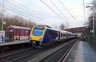
The Wakefield line is a railway line and service in the West Yorkshire Metro and South Yorkshire Passenger Transport Executive areas of northern England. The Wakefield line is coloured yellow on maps and publications by West Yorkshire Metro. The line was electrified in 1989, between Leeds & Wakefield Westgate, as part of the programme to electrify the East Coast Main Line.

<span class="mw-page-title-main">Heavy Woollen District</span> Localised area of West Yorkshire

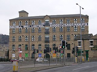
The Heavy Woollen District is a region of textile-focused industrial development in West Yorkshire, England. It acquired the name because of the heavyweight cloth manufactured there from the early 19th century.

<span class="mw-page-title-main">Wrenthorpe</span> Village in West Yorkshire, England

Wrenthorpe is a village north-west of Wakefield, in West Yorkshire, England. It is located in the Rhubarb Triangle.

<span class="mw-page-title-main">Rhubarb Triangle</span> Rhubarb-producing area in England

The Rhubarb Triangle is a 9-square-mile (23 km2) area of West Yorkshire, England between Wakefield, Morley, and Rothwell famous for producing early forced rhubarb. It includes Kirkhamgate, East Ardsley, Stanley, Lofthouse and Carlton. The Rhubarb Triangle was originally much bigger, covering an area between Leeds, Bradford and Wakefield. From the 1900s to 1930s, the rhubarb industry expanded and at its peak covered an area of about 30 square miles (78 km2).

<span class="mw-page-title-main">Outwood, Wakefield</span> Settlement in West Yorkshire, England

Outwood is a district to the north of Wakefield in West Yorkshire, England. The district is centred on the A61 Leeds Road south of Lofthouse. It grew up as a pit village and was only a small settlement until the 1970s, when construction of new houses caused it to grow and merge with neighbouring settlements such as Wrenthorpe and Stanley. In 2001, it had a population of 7,623.

<span class="mw-page-title-main">Kirkhamgate</span> Human settlement in England

Kirkhamgate is a village in the Wakefield district, in West Yorkshire, England. It originated as a hamlet in the Alverthorpe township in the parish of Wakefield in the West Riding of Yorkshire.

<span class="mw-page-title-main">Silcoates School</span> School in Wakefield, West Yorkshire, England

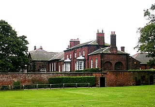
Silcoates School is a co-educational independent school in the village of Wrenthorpe near Wakefield, England.

Alverthorpe railway station served the village of Alverthorpe near Wakefield in the English county of West Yorkshire.

<span class="mw-page-title-main">Barkisland</span> Village in West Yorkshire, England

Barkisland is a village in Calderdale, West Yorkshire, England. Historically part of the West Riding of Yorkshire, it is 1 mile (1.6 km) east of Ripponden, 2 miles (3.2 km) south of Sowerby Bridge and 4 miles (6.4 km) south-west of Halifax town centre.

<span class="mw-page-title-main">Bradford Dale (Yorkshire)</span> Valley in West Yorkshire, England

Bradford Dale, is a side valley of Airedale that feeds water from Bradford Beck across the City of Bradford into the River Aire at Shipley in West Yorkshire, England. Whilst it is in Yorkshire and a dale, it is not part of the Yorkshire Dales and has more in common with Lower Nidderdale and Lower Airedale for its industrialisation.

<span class="mw-page-title-main">Bradford, Wakefield and Leeds Railway</span> Railway Company

The Bradford, Wakefield and Leeds Railway was an independent railway company that built a line between Wakefield and a junction close to Leeds, in Yorkshire, England. It opened its main line in 1857, and was worked by the Great Northern Railway. The line shortened the GNR route to Leeds.

Wrenthorpe and Outwood West is a former ward in the metropolitan borough of the City of Wakefield, West Yorkshire, England. It contains five listed buildings that are recorded in the National Heritage List for England. All the listed buildings are designated at Grade II, the lowest of the three grades, which is applied to "buildings of national importance and special interest". The former ward includes the village of Wrenthorpe, parts of Outwood, and Alverthorpe, and the surrounding area. The listed buildings consist of houses, and house and school, and a church.

<span class="mw-page-title-main">Westgate Unitarian Chapel</span>

Westgate Unitarian Chapel is a historic chapel in the city centre of Wakefield, in West Yorkshire, England.

References

  1. 1 2 3 4 Lewis, Samuel (1848). Alverthorpe. A Topographical Dictionary of England. British History Online. pp. 49–53. Retrieved 4 February 2011.
  2. "History of Alverthorpe, in Wakefield and West Riding | Map and description". Visionofbritain.org.uk. Retrieved 31 May 2015.
  3. 1 2 3 4 5 Ken Bartlett (1998). Alverthorpe and Low Laithes. Archived from the original on 13 June 2011. Retrieved 3 February 2011.
  4. "Flanshaw". Visitor UK. Retrieved 4 February 2011.
  5. Ben Asquith (2007). "Brandy Carr Nurseries - Our History". Archived from the original on 23 February 2011. Retrieved 11 February 2011.
  6. "Alverthorpe". Visitor UK. Retrieved 10 February 2011.
  7. "Wakefield Workhouses". workhouses.org.uk. Archived from the original on 5 June 2011. Retrieved 4 February 2011.
  8. "Local Nature Reserves". Natural England. Retrieved 1 February 2011.
  9. "Sirdar". 2008–2010. Retrieved 3 February 2011.
  10. Charlie Walker (November 2000). Wakefield its times and its peoples. Charles Walker. p. 73. ISBN   978-0-9537432-1-6.
  11. "Headteacher's Welcome". Alverthorpe St Paul's. Retrieved 26 April 2020.
  12. White's General and Commercial Directory of Wakefield, Horbury, Alverthorpe, Sandal Magna, Stanley and Normanton. 1887. Retrieved 2 February 2011.
  13. Thomas Allen (1831). A new and complete history of the county of York. p.  463 . Retrieved 11 February 2011.
  14. "Measuring Worth - Relative Value of UK Pounds". Measuring Worth. 31 December 2017. Archived from the original on 14 October 2008. Retrieved 1 January 2018.
  15. "St Paul's Church, Alverthorpe". Treasures Revealed in West Yorkshire. Archived from the original on 9 March 2012. Retrieved 11 February 2011.
  16. "Harry Willcock" The Scotsman 14 June 2006; location confirmed by 1953 National Probate Calendar