
Port Alberni is a city located on Vancouver Island in the province of British Columbia, Canada. The city lies within the Alberni Valley at the head of the Alberni Inlet, Vancouver Island's longest inlet. It is the location of the head offices of the Alberni-Clayoquot Regional District. Port Alberni currently has a total population of 18,259.

The Rogue River in southwestern Oregon in the United States flows about 215 miles (346 km) in a generally westward direction from the Cascade Range to the Pacific Ocean. Known for its salmon runs, whitewater rafting, and rugged scenery, it was one of the original eight rivers named in the Wild and Scenic Rivers Act of 1968. Beginning near Crater Lake, which occupies the caldera left by the explosive volcanic eruption and collapse of Mount Mazama, the river flows through the geologically young High Cascades and the older Western Cascades, another volcanic province. Further west, the river passes through multiple exotic terranes of the more ancient Klamath Mountains. In the Kalmiopsis Wilderness section of the Rogue basin are some of the world's best examples of rocks that form the Earth's mantle. Near the mouth of the river, the only dinosaur fragments ever discovered in Oregon were found in the Otter Point Formation, along the coast of Curry County.

The Kalamazoo River is a river in the U.S. state of Michigan. The river is 130 miles (210 km) long from the junction of its North and South branches to its mouth at Lake Michigan, with a total length extending to 178 miles (286 km) when one includes the South Branch. The river's watershed drains an area of approximately 2,020 square miles (5,200 km2) and drains portions of eight counties in southwest Michigan: Allegan, Barry, Eaton, Van Buren, Kalamazoo, Calhoun, Jackson, Hillsdale, Kent and Ottawa. The river has a median flow of 1,863 cubic feet per second (52.8 m3/s) at New Richmond, upstream from its mouth at Saugatuck and Douglas.

The Hackensack River is a river, approximately 45 miles (72 km) long, in the U.S. states of New York and New Jersey, emptying into Newark Bay, a back chamber of New York Harbor. The watershed of the river includes part of the suburban area outside New York City just west of the lower Hudson River, which it roughly parallels, separated from it by the New Jersey Palisades. It also flows through and drains the New Jersey Meadowlands. The lower river, which is navigable as far as the city of Hackensack, is heavily industrialized and forms a commercial extension of Newark Bay. Once believed to be among the most polluted watercourses in the United States, it staged a modest revival by the late 2000s.
The Rahway River is a river in Essex, Middlesex, and Union Counties, New Jersey, United States, The Rahway, along with the Elizabeth River, Piles Creek, Passaic River, Morses Creek, the Fresh Kills River, has its river mouth at the Arthur Kill.

Onondaga Lake is a lake in Central New York, immediately northwest of and adjacent to Syracuse, New York. The southeastern end of the lake and the southwestern shore abut industrial areas and expressways; the northeastern shore and northwestern end border a series of parks and museums.

The River Raisin is a river in southeastern Michigan, United States, that flows through glacial sediments into Lake Erie. The area today is an agricultural and industrial center of Michigan. The river flows for almost 139 miles (224 km), draining an area of 1,072 square miles (2,780 km2) in the Michigan counties of Lenawee, Washtenaw, Jackson, Hillsdale, and Monroe County, where its mouth at Lake Erie is located. French settlers named it as La Rivière aux Raisins because of the wild grapes growing along its banks, the French word for grape being raisin. The French term for "raisin" is raisin sec.
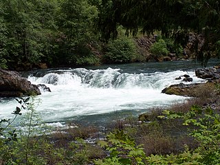
The North Umpqua River is a tributary of the Umpqua River, about 106 miles (171 km) long, in southwestern Oregon in the United States. It drains a scenic and rugged area of the Cascade Range southeast of Eugene, flowing through steep canyons and surrounded by large Douglas-fir forests. Renowned for its emerald green waters, it is considered one of the best fly fishing streams in the Pacific Northwest for anadromous fish.

Lake Oroville is a reservoir formed by the Oroville Dam impounding the Feather River, located in Butte County, northern California. The lake is situated 5 miles (8 km) northeast of the city of Oroville, within the Lake Oroville State Recreation Area, in the western foothills of the Sierra Nevada. Known as the second-largest reservoir in California, Lake Oroville is treated as a keystone facility within the California State Water Project by storing water, providing flood control, recreation, freshwater releases assist in controlling the salinity intrusion into the Sacramento-San Joaquin Delta and protecting fish and wildlife.
Asubpeeschoseewagong First Nation is an Ojibwe First Nations band government who inhabit northern Kenora in Ontario, Canada. Their landbase is the 4,145 ha English River 21 Indian Reserve. It has a registered population of 1,595 as of October 2019, of which the on-reserve population was 971. As of October 2020, the community had a population of approximately 1,200. They are a signatory to Treaty 3.
Mount Currie is in the Squamish-Lillooet region of southwestern British Columbia. On BC Highway 99, the locality is by road about 160 kilometres (99 mi) north of Vancouver, 39 kilometres (24 mi) northeast of Whistler, and 92 kilometres (57 mi) southwest of Lillooet.
The Oregon Department of Fish and Wildlife (ODFW) is an agency of the government of the U.S. state of Oregon responsible for programs protecting Oregon fish and wildlife resources and their habitats. The agency operates hatcheries, issues hunting and angling licenses, advises on habitat protection, and sponsors public education programs. Its history dates to the 1878 establishment of the office of Columbia River Fish Warden. Since 1931, enforcement of Oregon's Fish and Game laws has been the responsibility of the Oregon State Police rather than separate wardens.

Lost Creek Lake is a reservoir located on the Rogue River in Jackson County, Oregon, United States. The lake is impounded by William L. Jess Dam which was constructed by the U.S. Army Corps of Engineers in 1977 for flood control and fisheries enhancement. The lake and dam were the first completed elements of the multi-purpose Rogue River Basin Project, consisting of Lost Creek Lake, Applegate Lake and the Elk Creek project. The lake is located approximately 27 miles (43 km) northeast of Medford.
The Noosa River is a river situated in South East Queensland. The catchment starts in the Como Escarpment near Mount Elliott in the coastal Great Sandy National Park and meanders south through a lakes district around Tewantin.

The Lake Fish Hatchery Historic District comprises nine buildings built between 1930 and 1932 by the U.S. Fish and Wildlife Service in the National Park Service Rustic style. The buildings exhibit a consistency of style and construction, with exposed gable trusses and oversized paired logs at the corners, all with brown paint. The district is located on the shore of Yellowstone lake near the Lake Hotel The hatchery was established to provide Yellowstone cutthroat trout eggs for state and federal hatcheries outside Yellowstone.

The Adams River is a tributary to the Thompson and Fraser Rivers in British Columbia, Canada. Beginning in the Monashee Mountains to the north, the Upper Adams River flows mainly southward and eventually reaches Adams Lake. The Lower Adams River begins at the southern end of the lake and flows into the extreme western end of Shuswap Lake. The river is one of the most important sockeye salmon breeding areas in North America. The run occurs in mid-October and can bring millions of fish to a concentrated area near the river mouth. Excavations of Secwepemc villages on the river have shown a long tradition of habitation and salmon fishing in the area. The river also served as an important transportation route for early logging operations in the watershed.

The Mount Whitney Fish Hatchery, located in Independence, California, in the United States, is an historic fish hatchery that has played an important role in the preservation of the golden trout, California's state fish.

Big Butte Creek is a 12-mile-long (19 km) tributary of the Rogue River in the U.S. state of Oregon. It drains approximately 245 square miles (635 km2) of Jackson County. Its two forks, the North Fork and the South Fork, both begin high in the Cascade Range near Mount McLoughlin. Flowing predominantly west, they meet near the city of Butte Falls. The main stem flows generally northwest until it empties into the Rogue Falls was incorporated in 1911, and remains the only incorporated town within the watershed's boundaries.
Many of the issues have been attributed to policies that were made during the early Soviet Union, at a time when many officials felt that pollution control was an unnecessary hindrance to economic development and industrialization, and, even though numerous attempts were made by the Soviet government to alleviate the situation in the 1960s, 1970s and 1980s, the problems were not completely solved. By the 1990s, 40% of Russia's territory began demonstrating symptoms of significant ecological stress, largely due to a diverse number of environmental issues, including deforestation, energy irresponsibility, pollution, and nuclear waste. According to Russia's Ministry of Natural Resources and Environment, Russia is currently warming 2.5 times faster than the rest of the globe.
Nada Lake is a freshwater reservoir lakes located on the eastern slope of The Enchantments, in Chelan County, Washington. Self-issued Alpine Lakes Wilderness permits are required for transit within the Snow Lakes area.
