
The Apalachee were an Indigenous people of the Southeastern Woodlands, specifically an Indigenous people of Florida, who lived in the Florida Panhandle until the early 18th century. They lived between the Aucilla River and Ochlockonee River, at the head of Apalachee Bay, an area known as the Apalachee Province. They spoke a Muskogean language called Apalachee, which is now extinct.
Tocobaga was the name of a chiefdom, its chief, and its principal town during the 16th century. The chiefdom was centered around the northern end of Old Tampa Bay, the arm of Tampa Bay that extends between the present-day city of Tampa and northern Pinellas County. The exact location of the principal town is believed to be the archeological Safety Harbor site, which gives its name to the Safety Harbor culture, of which the Tocobaga are the most well-known group.
The Potano tribe lived in north-central Florida at the time of first European contact. Their territory included what is now Alachua County, the northern half of Marion County and the western part of Putnam County. This territory corresponds to that of the Alachua culture, which lasted from about 700 until 1700. The Potano were among the many tribes of the Timucua people, and spoke a dialect of the Timucua language.

Mission San Luis de Apalachee was a Spanish Franciscan mission built in 1656 in the Florida Panhandle, two miles west of the present-day Florida Capitol Building in Tallahassee, Florida. It was located in the descendent settlement of Anhaica capital of Apalachee Province. The mission was part of Spain's effort to colonize the Florida Peninsula and to convert the Timucuan and Apalachee Indians to Christianity. The mission lasted until 1704 when it was evacuated and destroyed to prevent its use by an approaching militia of Creek Indians and South Carolinians.

The Mocama were a Native American people who lived in the coastal areas of what are now northern Florida and southeastern Georgia. A Timucua group, they spoke the dialect known as Mocama, the best-attested dialect of the Timucua language. Their heartland extended from about the Altamaha River in Georgia to south of the mouth of the St. John's River, covering the Sea Islands and the inland waterways, Intracoastal. and much of present-day Jacksonville. At the time of contact with Europeans, there were two major chiefdoms among the Mocama, the Saturiwa and the Tacatacuru, each of which evidently had authority over multiple villages. The Saturiwa controlled chiefdoms stretching to modern day St. Augustine, but the native peoples of these chiefdoms have been identified by Pareja as speaking Agua Salada, which may have been a distinct dialect.

Beginning in the second half of the 16th century, the Kingdom of Spain established a number of missions throughout La Florida in order to convert the Native Americans to Christianity, to facilitate control of the area, and to prevent its colonization by other countries, in particular, England and France. Spanish Florida originally included much of what is now the Southeastern United States, although Spain never exercised long-term effective control over more than the northern part of what is now the State of Florida from present-day St. Augustine to the area around Tallahassee, southeastern Georgia, and some coastal settlements, such as Pensacola, Florida. A few short-lived missions were established in other locations, including Mission Santa Elena in present-day South Carolina, around the Florida peninsula, and in the interior of Georgia and Alabama.
The Chisca were a tribe of Native Americans living in present-day eastern Tennessee and southwestern Virginia in the 16th century, and in present-day Alabama, Georgia, and Florida in the 17th, 18th, and early 19th centuries, by which time they were known as Yuchi. The Hernando de Soto expedition heard of, and may have had brief contact with, the Chisca in 1540. The Juan Pardo expeditions of 1566 and 1568 encountered the Chisca, and engaged in battles with them. By early in the 17th century, Chisca people were present in several parts of Spanish Florida, engaged at various times and places in alternately friendly or hostile relations with the Spanish and the peoples of the Spanish mission system. After the capture of a fortified Chisca town by the Spanish and Apalachee in 1677, some Chisca took refuge in northern Tennessee, where they were absorbed into the Shawnee, and in Muscogee towns in Alabama. Around the turn of the 18th century some Chisca, by then generally called Yuchi, joined the Apalachicola Province towns that resettled around Ochisi Creek in central Georgia, thus becoming part of the "Lower Towns of the Muscogee Confederacy". A few Chiscas remained in western Florida into the middle of the 18th century.
The Spanish missions in Georgia comprised a series of religious outposts established by Spanish Catholics in order to spread the Christian doctrine among the Guale and various Timucua peoples in southeastern Georgia.
The Surruque people lived along the middle Atlantic coast of Florida during the 16th and 17th centuries. They may have spoken a dialect of the Timucua language, but were allied with the Ais. The Surruque became clients of the Spanish government in St. Augustine, but were not successfully brought into the Spanish mission system.
Apalachicola was the name of a Native American tribal town, and of a group of towns associated with it, which the Spanish called Apalachicola Province, located along the lower part of the Chattahoochee River in present-day Alabama and Georgia. It is believed that before the 17th century, the residents of all the Apalachicola towns spoke the Hitchiti language, although other towns whose people spoke the Muscogee language relocated among the Apalachicolas along the Chattahoochee River in the middle- to later- 17th century. All of the Apalachicola towns moved to central Georgia at the end of the 17th century, where the English called them "Ochese Creek Indians". They moved back to the Chattahoochee River after 1715, with the English then calling them "Lower Creeks", while the Spanish called them "Ochese".

The Chatot were a Native American tribe who lived in the upper Apalachicola River and Chipola River basins in what is now Florida. They spoke a Muskogean language, which may have been the same as that of several other peoples in western Florida, including the Amacano, Chine, Pacara, and Pensacola. Patricia Galloway, author of Choctaw Genesis, 1500–1700, posited that the Chatot were connected with the Choctaw. The Chatot were involved in a war with the Apalachee and Amacano people in 1639.
Acuera was the name of both an indigenous town and a province or region in central Florida during the 16th and 17th centuries. The indigenous people of Acuera spoke a dialect of the Timucua language. In 1539 the town first encountered Europeans when it was raided by soldiers of Hernando de Soto's expedition. French colonists also knew this town during their brief tenure (1564–1565) in northern Florida.
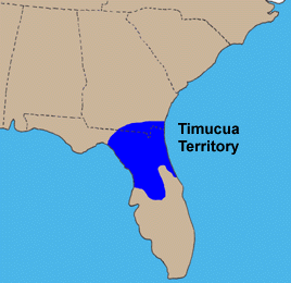
The Timucua were a Native American people who lived in Northeast and North Central Florida and southeast Georgia. They were the largest indigenous group in that area and consisted of about 35 chiefdoms, many leading thousands of people. The various groups of Timucua spoke several dialects of the Timucua language. At the time of European contact, Timucuan speakers occupied about 19,200 square miles (50,000 km2) in the present-day states of Florida and Georgia, with an estimated population of 200,000. Milanich notes that the population density calculated from those figures, 10.4 per square mile (4.0/km2) is close to the population densities calculated by other authors for the Bahamas and for Hispaniola at the time of first European contact. The territory occupied by Timucua speakers stretched from the Altamaha River and Cumberland Island in present-day Georgia as far south as Lake George in central Florida, and from the Atlantic Ocean west to the Aucilla River in the Florida Panhandle, though it reached the Gulf of Mexico at no more than a couple of points.
The indigenous peoples of Florida lived in what is now known as Florida for more than 12,000 years before the time of first contact with Europeans. However, the indigenous Floridians living east of the Apalachicola River had largely died out by the early 18th century. Some Apalachees migrated to Louisiana, where their descendants now live; some were taken to Cuba and Mexico by the Spanish in the 18th century, and a few may have been absorbed into the Seminole and Miccosukee tribes.

Mocoso was the name of a 16th-century chiefdom located on the east side of Tampa Bay, Florida near the mouth of the Alafia River, of its chief town and of its chief. Mocoso was also the name of a 17th-century village in the province of Acuera, a branch of the Timucua. The people of both villages are believed to have been speakers of the Timucua language.
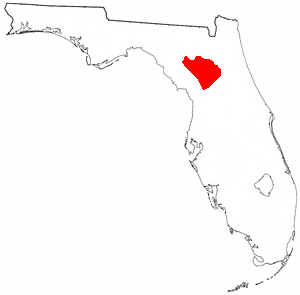
The Yustaga were a Timucua people of what is now northwestern Florida during the 16th and 17th centuries. The westernmost Timucua group, they lived between the Aucilla and Suwannee Rivers in the Florida Panhandle, just east of the Apalachee people. A dominant force in regional tribal politics, they may have been organized as a loose regional chiefdom consisting of up to eight smaller local chiefdoms.
Ocale was the name of a town in Florida visited by the Hernando de Soto expedition, and of a putative chiefdom of the Timucua people. The town was probably close to the Withlacoochee River at the time of de Soto's visit, and may have later been moved to the Oklawaha River.
Arapaha was a Timucua town on the Alapaha River in the 17th century. The name was also sometimes used to designate a province or sub-province in Spanish Florida.
Damián de Vega Castro y Pardo was the governor of the Spanish province of La Florida from November 26, 1638 to April 10, 1645.
The Chine people were a group of Native American people living in Apalachee Province in Spanish Florida from the early 1670s until the end of the 17th century. They are believed to have spoken the same language as the Chatot, Amacano, Pacara, and Pensacola people, and have been described as a band of the Chatot people. They were served by a series of Spanish missions in the last quarter of the 17th century.
