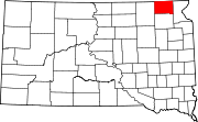
Washington County is a county located in the U.S. state of Kansas. Its county seat and largest city is Washington. As of the 2020 census, the county population was 5,530. The county was named for George Washington, the 1st president of the United States.

Vernon is a village in Marion County, Illinois, United States. The population was 103 at the 2020 census.

The Ogallala Aquifer is a shallow water table aquifer surrounded by sand, silt, clay, and gravel located beneath the Great Plains in the United States. As one of the world's largest aquifers, it underlies an area of approximately 174,000 sq mi (450,000 km2) in portions of eight states. It was named in 1898 by geologist N. H. Darton from its type locality near the town of Ogallala, Nebraska. The aquifer is part of the High Plains Aquifer System, and resides in the Ogallala Formation, which is the principal geologic unit underlying 80% of the High Plains.

The Cheyenne River, also written Chyone, referring to the Cheyenne people who once lived there, is a tributary of the Missouri River in the U.S. states of Wyoming and South Dakota. It is approximately 295 miles (475 km) long and drains an area of 24,240 square miles (62,800 km2). About 60% of the drainage basin is in South Dakota and almost all of the remainder is in Wyoming.
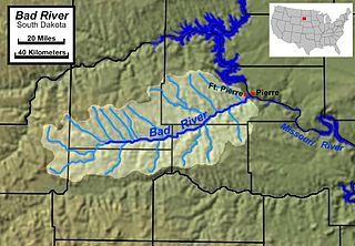
The Bad River is a tributary of the Missouri River, approximately 161 miles (259 km) long, in central South Dakota in the United States. The river is formed at Philip, South Dakota, by the confluence of its North and South forks. The North Fork Bad River rises in eastern Pennington County and flows 51 miles (82 km) east-southeast to Philip, while the South Fork Bad River rises at the confluence of Whitewater Creek and Big Buffalo Creek in Jackson County, within the Buffalo Gap National Grassland, and flows 36 miles (58 km) northeast to Philip. The main stem of the Bad River flows east-northeast from Philip, passing Midland and Capa. It joins the Missouri at Fort Pierre. The Bad drainage basin is about 3,000 square miles (7,800 km2) and is located south of the Cheyenne River in the Pierre Hills and Southern Plateaus.

The White River is a Missouri River tributary that flows 580 miles (930 km) through the U.S. states of Nebraska and South Dakota. The name stems from the water's white-gray color, a function of eroded sand, clay, and volcanic ash carried by the river from its source near the Badlands. Draining a basin of about 10,200 square miles (26,000 km2), about 8,500 square miles (22,000 km2) of which is in South Dakota, the stream flows through a region of sparsely populated hills, plateaus, and badlands.
Enbridge Inc. is a multinational pipeline and energy company headquartered in Calgary, Alberta, Canada. Enbridge owns and operates pipelines throughout Canada and the United States, transporting crude oil, natural gas, and natural gas liquids. Enbridge's pipeline system is the longest in North America and the largest oil export pipeline network in the world. Its crude oil system consists of 28,661 kilometres of pipelines. Its 38,300 kilometre natural gas pipeline system connects multiple Canadian provinces, several US states, and the Gulf of Mexico. The company was formed by Imperial Oil in 1949 as the Interprovincial Pipe Line Company Limited to transport Alberta oil to refineries. Over time, it has grown through acquisition of other existing pipeline companies and the expansion of their projects. Between 2012 and 2021, Enbridge transported over 32 billion barrels of crude oil.

TC Energy Corporation is a major North American energy company, based in the TC Energy Tower building in Calgary, Alberta, Canada, that develops and operates energy infrastructure in Canada, the United States, and Mexico. The company operates three core businesses: Natural Gas Pipelines, Liquids Pipelines and Energy.
The Enbridge Pipeline System is an oil pipeline system which transports crude oil and dilbit from Canada to the United States. The system exceeds 5,000 kilometres (3,100 mi) in length including multiple paths. More than 3,000 kilometres (1,900 mi) of the system is in the United States while the rest is in Canada and serves the Athabasca oil sands production facilities. Main parts of the system are 2,306-kilometre-long (1,433 mi) Canadian Mainline and 3,057-kilometre-long (1,900 mi) Lakehead System. On average, it delivers 1.4 million barrels per day of crude oil and other products to the major oil refineries in the American Midwest and the Canadian province of Ontario. The Canadian portion is owned by Enbridge, while the U.S. portion is partly owned by that company through Enbridge Energy Partners, LP, formerly known as Lakehead Pipe Line Partners and Lakehead Pipe Line Company.

Rock is an unincorporated community in Cowley County, Kansas, United States. As of the 2020 census, the population of the community and nearby areas was 94.
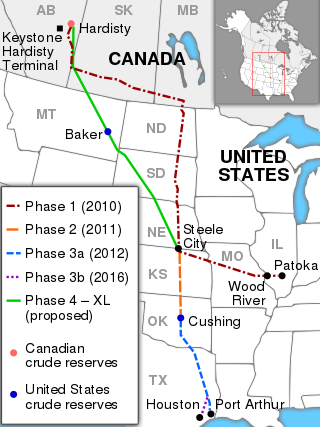
The Keystone Pipeline System is an oil pipeline system in Canada and the United States, commissioned in 2010 and owned by TC Energy and, as of March 2020, the Government of Alberta. It runs from the Western Canadian Sedimentary Basin in Alberta to refineries in Illinois and Texas, and also to oil tank farms and an oil pipeline distribution center in Cushing, Oklahoma.

Pilsen is an unincorporated community in Marion County, Kansas, United States. As of the 2020 census, the population of the community and nearby areas was 65. The community is named after the city Plzeň in Czech Republic, formerly Bohemia. It is located north of Marion and west of Lincolnville at the intersection of Remington Road and 275th Street.

The Kalamazoo River oil spill occurred in July 2010 when a pipeline operated by Enbridge burst and flowed into Talmadge Creek, a tributary of the Kalamazoo River near Marshall, Michigan. A 6-foot (1.8 m) break in the pipeline resulted in one of the largest inland oil spills in U.S. history. The pipeline carries diluted bitumen (dilbit), a heavy crude oil from Canada's Athabasca oil sands to the United States. Cleanup took five years. Following the spill, the volatile hydrocarbon diluents evaporated, leaving the heavier bitumen to sink in the water column. Thirty-five miles (56 km) of the Kalamazoo River were closed for clean-up until June 2012, when portions of the river were re-opened. On March 14, 2013, the Environmental Protection Agency (EPA) ordered Enbridge to return to dredge portions of the river to remove submerged oil and oil-contaminated sediment.

The Dakota Access Pipeline Protests, also called by the hashtag #NoDAPL, began in April 2016 as a grassroots opposition to the construction of Energy Transfer Partners' Dakota Access Pipeline in the northern United States and ended on February 23, 2017 when National Guard and law enforcement officers evicted the last remaining protesters. The pipeline runs from the Bakken oil fields in western North Dakota to southern Illinois, crossing beneath the Missouri and Mississippi rivers, as well as under part of Lake Oahe near the Standing Rock Indian Reservation. Many members of the Standing Rock tribe and surrounding communities consider the pipeline to be a serious threat to the region's water. The construction also directly threatens ancient burial grounds and cultural sites of historic importance.

Scatter Their Own was a Rock Band by Scott Clifford. In the Lakota language, the tribe name Oglala translates to "scatter one's own", desiring to scatter Lakota perspective throughout the country.

The Dakota Access Pipeline (DAPL) or Bakken pipeline is a 1,172-mile-long (1,886 km) underground pipeline in the United States that has the ability to transport up to 750,000 barrels of light sweet crude oil per day. It begins in the shale oil fields of the Bakken Formation in northwest North Dakota and continues through South Dakota and Iowa to an oil terminal near Patoka, Illinois. Together with the Energy Transfer Crude Oil Pipeline from Patoka to Nederland, Texas, it forms the Bakken system. The pipeline transports 40 percent of the oil produced in the Bakken region.