Ammophila breviligulata

Last updated

American beachgrass
AmericanMarramGrassKohlerAndraeStateParkLakeMichigan.jpg
American beachgrass in Kohler-Andrae State Park on Lake Michigan in November; note the seed heads rising above the leaves.
Scientific classification OOjs UI icon edit-ltr.svg
Kingdom: Plantae
Clade: Tracheophytes
Clade: Angiosperms
Clade: Monocots
Clade: Commelinids
Order: Poales
Family: Poaceae
Genus: Ammophila
Species:
A. breviligulata
Binomial name
Ammophila breviligulata

Ammophila breviligulata (American beachgrass or American marram grass) is a species of grass native to eastern North America, where it grows on sand dunes along the Atlantic Ocean and Great Lakes coasts. Beachgrass thrives under conditions of shifting sand, sand burial, and high winds; it is a dune-building grass that builds the first line of sand dunes along the coast. Beachgrass is less vigorous in stabilized sand, and is only infrequently found further inland than the coastal foredunes. On the Atlantic coastline of North America, Ammophila breviligulata has been observed as far south as North Carolina, [1] [2] [3] and is often planted in dune restoration projects. Ammophila breviligulata was introduced to the Pacific coast of North America in the 1930s. It is proving to be invasive, and is increasingly important to coastal ecology and development in Oregon, Washington, and British Columbia.

Contents

Description

American beachgrass on Lake Michigan in Spring. Ammophila breviligulata Leland June.jpg
American beachgrass on Lake Michigan in Spring.

Ammophila breviligulata is perennial grass which produces an extensive rhizome system. The leaves have deeply furrowed upper surfaces and smooth undersides, and grow 1 to 3 feet (0.3 to 0.9 m) tall. The plant's inflorescence is a spike-like panicle that can reach 10 inches (25 cm) long; The spikelet is single-flowered, awnless. [4] The seed head appears in late July or August. [5] The species name breviligulata derives from the Latin brevis ("short") and ligula ("tongue"), [6] which refers to a feature of grass leaves called the ligule.

Two varieties of American beachgrass growing on the eastern shore of Lake Ontario. The greener stand in the distance is Cape variety, and has been introduced to this area; it is native to the Atlantic Ocean coasts of North America. The browner stand in the foreground is the native "Champlain beachgrass" (sometimes considered a separate species A. champlainensis). Beachgrass (2 varieties) Black Pond WMA.jpg
Two varieties of American beachgrass growing on the eastern shore of Lake Ontario. The greener stand in the distance is Cape variety, and has been introduced to this area; it is native to the Atlantic Ocean coasts of North America. The browner stand in the foreground is the native "Champlain beachgrass" (sometimes considered a separate species A. champlain­ensis).

Ammophila breviligulata is quite similar in appearance and ecology to a second species of beachgrass, Ammophila arenaria (European beachgrass). As Nick Page has summarized, "Ammophila breviligulata is distinguished from A. arenaria by smaller ligules (1–3 mm versus 10–30 mm long in A. arenaria), wider and less inrolled leaves, longer flower spike (25–35 cm versus 15–25 cm long in A. arenaria), and scaly rather than puberulent leaf veins on the upper leaf surface." [7]

Ecology

Both species of beachgrass are noted for their association with stable sand dunes, and observations in regions where they were introduced to coasts indicate that they build the first line of dunes on coasts (the foredunes). The plants spread rapidly – 6 to 10 feet (1.8 to 3.0 m) annually – through the sand by subsurface runners (rhizomes), and can produce up to 100 stems per clump annually. [8] They can tolerate burial in as much as 3 feet (0.9 m) of sand; sand burial stimulates the rhizomes to grow vertically, and is essential to plant vigor. [9] The beachgrass species are also very good examples of xerophytes, being able to thrive on arid to semi-arid beach dunes. The plant has several mechanisms for adapting to heat stress or wind. The long narrow leaves can roll or fold, and the rough upper leaf surface, which contains the gas exchange openings (stomata), can orient itself away from the wind. [8]

Beachgrass is a dominant species on foredunes, and is sometimes the only plant found there, but is unable to grow farther inland on stabilized dunes and soil. One reason for this that has been extensively studied by Wim van der Putten and his colleagues is based on the susceptibility of Ammophila species to soil pathogens such as nematodes. [10] [11] The density of these pathogens is low in freshly deposited sand, but builds up in the roots of beachgrass on stabilized sand. While the details are complex, the result is that beachgrass is largely limited to the foredunes that it builds, which are immediately adjacent to the water's edge and where sand is removed and redeposited fairly frequently.

Around the Great Lakes, it is limited to active dune habitats along the shores, and it is listed a threatened species in Minnesota where it reaches its most westerly natural range around Duluth. [4] [12]

Invasiveness

Starting in the 19th century, A. arenaria was introduced to the Pacific coast of North America to help control beach sands; it serves this role so well that it is now considered invasive not only along this coast (from California north to British Columbia), but along nearly every coast worldwide where it has been introduced. [7] [9] [13] [14] Ammophila arenaria built foredunes (the dunes closest to the beach) that are typically about 14 feet (4.3 m) high, which is much higher than the dunes associated with the native dune grass species Leymus mollis . [15]

In the 1930s, A. breviligulata was introduced to about 3,000 acres (1,200 ha) on the Clatsop Peninsula in Oregon. [15] [16] Since then, A. breviligulata has gradually supplanted A. arenaria in Oregon and Washington; the precise reason for the relative success of A. breviligulata isn't known. The most recognizable aspect of the changeover between the beachgrass species is that the foredunes of A. breviligulata are shorter than the foredunes of A. arenaria; foredunes of A. breviligulata are about 9 feet (2.7 m) high in this region. The diversity of other species that co-exist with mature stands of A. arenaria is comparable to the species diversity with A. breviligulata. However, the lower foredune height for the latter means that coastal ecosystems that had adapted to the fairly tall foredunes of A. arenaria are again changing, especially in the regions just behind the foredune and sheltered by it. Similarly, buildings and roads that were constructed under the presumption of continuing protection by the tall A. arenaria foredunes may now be threatened by shifting sand and by increased exposure to wind and water in storms. [17]

Related Research Articles

<span class="mw-page-title-main">Dune</span> Hill of loose sand built by aeolian processes or the flow of water

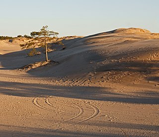
A dune is a landform composed of wind- or water-driven sand. It typically takes the form of a mound, ridge, or hill. An area with dunes is called a dune system or a dune complex. A large dune complex is called a dune field, while broad, flat regions covered with wind-swept sand or dunes with little or no vegetation are called ergs or sand seas. Dunes occur in different shapes and sizes, but most kinds of dunes are longer on the stoss (upflow) side, where the sand is pushed up the dune, and have a shorter slip face in the lee side. The valley or trough between dunes is called a dune slack.

<i>Ammophila</i> (plant) Genus of flowering plants in the grass family Poaceae

Ammophila is a genus of flowering plants consisting of two or three very similar species of grasses. The common names for these grasses include marram grass, bent grass, and beachgrass. These grasses are found almost exclusively on the first line of coastal sand dunes. Their extensive systems of creeping underground stems or rhizomes allow them to thrive under conditions of shifting sands and high winds, and to help stabilize and prevent coastal erosion. Ammophila species are native to the coasts of the North Atlantic Ocean where they are usually the dominant species on sand dunes. Their native range includes few inland regions, with the Great Lakes of North America being the main exception. The genus name Ammophila originates from the Greek words ἄμμος (ámmos), meaning "sand", and φίλος (philos), meaning "friend".

<span class="mw-page-title-main">Oregon Dunes National Recreation Area</span> Expanse of coastal sand dunes in North America

The Oregon Dunes National Recreation Area is located on the Oregon Coast, stretching approximately 40 miles (64 km) north of the Coos River in North Bend to the Siuslaw River in Florence, and adjoining Honeyman State Park on the west. It is part of Siuslaw National Forest and is administered by the United States Forest Service.

<span class="mw-page-title-main">Grey dune</span>

Grey dunes are fixed, stable sand dunes that are covered by a continuous layer of herbaceous vegetation. These dunes are typically located 50–100 meters from the ocean shore and are found on the landward side of foredunes. Grey dunes are named for their characteristic grey color which is a result of the ground cover of lichen combined with a top soil layer of humus.

NVC community SD11 is one of the 16 sand-dune communities in the British National Vegetation Classification system.

<i>Uniola paniculata</i> Species of flowering plant

Uniola paniculata, also known as sea oats, seaside oats, araña, and arroz de costa, is a tall subtropical grass that is an important component of coastal sand dune and beach plant communities in the southeastern United States, eastern Mexico and some Caribbean islands.

<i>Ammophila arenaria</i> Species of flowering plant in the grass family Poaceae

Ammophila arenaria is a species of grass in the family Poaceae. It is known by the common names marram grass and European beachgrass. It is one of two species of the genus Ammophila. It is native to the coastlines of Europe and North Africa where it grows in the sands of beach dunes. It is a perennial grass forming stiff, hardy clumps of erect stems up to 1.2 metres (3.9 ft) in height. It grows from a network of thick rhizomes which give it a sturdy anchor in its sand substrate and allow it to spread upward as sand accumulates. These rhizomes can grow laterally by 2 metres in six months. One clump can produce 100 new shoots annually.

<span class="mw-page-title-main">Tuckernuck Island</span>

<span class="mw-page-title-main">New River (Oregon)</span> River in Oregon, United States

The New River is a stream, about 8 miles (13 km) long, on the southern coast of the U.S. state of Oregon. It begins slightly north of Floras Lake, at the confluence of the lake outlet and Floras Creek, and runs north behind a foredune until entering the Pacific Ocean between Bandon and Port Orford.

Sand dune ecology describes the biological and physico-chemical interactions that are a characteristic of sand dunes.

<span class="mw-page-title-main">Lanphere Dunes</span>

The Lanphere Dunes National Natural Landmark a unit of the Humboldt Bay National Wildlife Refuge Complex, is located in Humboldt County, California. The dune complex consists of the wave slope, fore dune, herbaceous and woody swales, coniferous and riparian forest, freshwater swamp, freshwater marsh, brackish marsh, salt marsh, and intertidal mudflats. The site exemplifies dunes succession.

NVC community SD19 is one of the 16 sand-dune communities in the British National Vegetation Classification system. It is one of six communities associated with foredunes and mobile dunes.

<span class="mw-page-title-main">Sand dune stabilization</span> Coastal management practice

Sand dune stabilization is a coastal management practice designed to prevent erosion of sand dunes. Sand dunes are common features of shoreline and desert environments. Dunes provide habitat for highly specialized plants and animals, including rare and endangered species. They can protect beaches from erosion and recruit sand to eroded beaches. Dunes are threatened by human activity, both intentional and unintentional. Countries such as the United States, Australia, Canada, New Zealand, the United Kingdom, and Netherlands, operate significant dune protection programs.

<span class="mw-page-title-main">Clatsop Spit</span>

Clatsop Spit is a giant sand spit on the Pacific coast along U.S. Route 101 between Astoria and the north end of Tillamook Head in Clatsop County, northwest Oregon at the mouth of the Columbia River. The Clatsop Spit was formed by Columbia River sediment brought to the coast by the river flow after the last ice age ended approximately 8500 years ago and the ocean level rose. Here it was worked over and shaped by the wind and the waves until a vast and sandy plain was formed. In regular conversation, referring to Clatsop Spit usually refers to the northern end of the spit: The area that is bound by the Pacific to the west and the Columbia River to the northeast. In the past, the spit was known as Clatsop Sands.

<i>Phacelia argentea</i> Species of plant

Phacelia argentea is a rare species of phacelia known by the common names sand dune phacelia and silvery phacelia. It is native to the coastline of southwestern Oregon and far northwestern California, where it was counted at a total of 33 sites in 1995. It is the only phacelia species endemic to coastal sand dune habitat, an ecosystem which is altered and declining in the area.

A foredune is a dune ridge that runs parallel to the shore of an ocean, lake, bay, or estuary. Foredunes consist of sand deposited by wind on a vegetated part of the shore. Foredunes can be classified generally as incipient or established.

<i>Leymus mollis</i> Species of grass

Leymus mollis is a species of grass known by the common names American dune grass, American dune wild-rye, sea lyme-grass, strand-wheat, and strand grass. Its Japanese name is hamaninniku. It is native to Asia, where it occurs in Japan, China, Korea, and Russia, and northern parts of North America, where it occurs across Canada and the northern United States, as well as Greenland. It can also be found in Iceland.

<span class="mw-page-title-main">Ma-le'l Dunes</span>

The Ma-le’l Dunes Cooperative Management Area (CMA) is located south of Lanphere Dunes at the upper end of the North Spit of Humboldt Bay, being approximately one mile north of the unincorporated town of Manila and 3.5 miles west of the City of Arcata, in Humboldt County, California. It consists of approximately 444 acres of public land. Ma-le’l dunes are divided into northern and southern sections. The northern portion is part of Humboldt Bay National Wildlife Refuge and is administered by the U.S. Fish and Wildlife Service (FWS). The southern portion of Ma-le’l is managed by the Bureau of Land Management (BLM) and provides access to the coastal dune environment for dog-walking and equestrian use on designated trails.

<span class="mw-page-title-main">Wilbur Ternyik</span> American civic leader and land use planning advocate

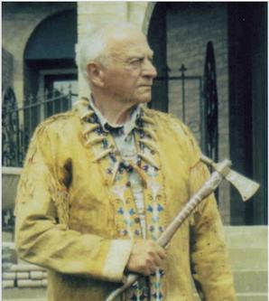
Wilbur E. Ternyik was an American civic leader who has been characterized as a founding father of coastal planning, a coastal advocate, and a guardian of the Oregon Coast. News coverage of his work has described him as an international expert on sand dunes, and has noted his "decades of work to protect the environment that draws thousands to the Oregon coast." Ternyik's outreach to skeptical local officials in the early 1970s, persuading them to engage with then-Governor Tom McCall's call for land use planning in advance of the state's landmark land use legislation, has been identified as his most significant achievement.

<span class="mw-page-title-main">Dynamic revetment</span>

Dynamic revetment, also known as a "cobble berm", uses gravel or cobble-sized rocks to mimic a natural cobble storm beach for the purpose of reducing wave energy and stopping or slowing coastal erosion. Unlike seawalls, dynamic revetment is designed to allow wave action to rearrange the stones into an equilibrium profile, disrupting wave action and dissipating wave energy as the cobbles move. This can reduce the wave reflection which often contributes to beach scouring.

References

  1. Goldstein, Evan B.; Mullins, Elsemarie V.; Moore, Laura J.; Biel, Reuben G.; Brown, Joseph K.; Hacker, Sally D.; Jay, Katya R.; Mostow, Rebecca S.; Ruggiero, Peter (2018-06-08). "Literature-based latitudinal distribution and possible range shifts of two US east coast dune grass species (Uniola paniculata and Ammophila breviligulata)". PeerJ. 6: e4932. doi: 10.7717/peerj.4932 . ISSN   2167-8359. PMC   5996817 . PMID   29900075.
  2. "US East Coast Dune Grass Literature Map". ebgoldstein.github.io. Retrieved 2018-06-08.
  3. Goldstein, Evan; Mullins, Elsemarie; Moore, Laura; Biel, Reuben; Brown, Joseph; Hacker, Sally; Jay, Katya; Mostow, Rebecca; Ruggiero, Peter; Zinnert, Julie (2018). "Data Portal - Data Package Summary | Long Term Ecological Research Network (LTER)". Environmental Data Initiative. doi:10.6073/pasta/bdbe9a609e0508fdb7e39bc41f75bf6f.{{cite journal}}: Cite journal requires |journal= (help)
  4. 1 2 Barbara Coffin; Lee Pfannmuller (1988). Minnesota's Endangered Flora and Fauna. U of Minnesota Press. p. 48. ISBN   978-0-8166-1689-3.
  5. "PLANTS Profile for Ammophila breviligulata (American beachgrass)". Baton Rouge, LA: U. S. Department of Agriculture, National Plant Data Center. Archived from the original on 20 September 2008. Retrieved 2008-09-18.
  6. "Ammophila breviligulata: Robert W. Freckmann Herbarium". University of Wisconsin. Archived from the original on 2007-07-02. Retrieved 2008-09-20.
  7. 1 2 Page, Nick (2001-11-15). Ceska, A. (ed.). "Ammophila breviligulata (Poaceae) new to British Columbia". Botanical Electronic News - BEN #276. Archived from the original on 27 August 2008. Retrieved 2008-09-19.
  8. 1 2 "Plant Fact Sheet: American Beachgrass" (PDF). United States Department of Agriculture. 2006-05-30. Archived (PDF) from the original on 20 September 2008. Retrieved 2008-10-07.
  9. 1 2 Apteker, Rachel. "Invasive Plants of California's Wildland: Ammophila arenaria". California Invasive Plants Council. Retrieved 2008-09-18.
  10. van der Putten, Wim H.; Peters, Bas A. M. (September 1997). "How soil-borne pathogens may affect plant competition". Ecology . 78 (6): 1785–1795. doi:10.1890/0012-9658(1997)078[1785:HSBPMA]2.0.CO;2. ISSN   0012-9658. JSTOR   2266101.
  11. van der Putten, Wim H. (September 2003). "Plant defense belowground and spatiotemporal processes in natural vegetation" (PDF). Ecology . 84 (9): 2269–2280. doi:10.1890/02-0284. hdl:20.500.11755/8ca02f26-57c5-4774-a00e-fd0ddddff9f6. JSTOR   3450133.
  12. "Ammophila breviligulata ssp. breviligulata : Beach Grass | Rare Species Guide". Minnesota Department of Natural Resources. Retrieved 2020-12-02.
  13. "Washington's Coast: Plants - Beachgrass". Washington State Department of Ecology. Archived from the original on 2008-02-28. Retrieved 2008-09-19.
  14. Dukes, Jeffrey S.; Mooney, Harold A. (2004). "Disruption of ecosystem processes in western North America by invasive species" (PDF). Revista Chilena de Historia Natural. 77 (3): 411–437. doi:10.4067/S0716-078X2004000300003.
  15. 1 2 Seabloom, E. W.; Wiedemann, A. M. (1994). "Distribution and effects of Ammophila breviligulata Fern. (American beachgrass) on the foredunes of the Washington coast". Journal of Coastal Research . 10 (1): 178–188. JSTOR   4298202.
  16. The town of Warrenton, Oregon and Fort Stevens State Park presently occupy the Clatsop Peninsula, which juts into the mouth of the Columbia River as it enters the Pacific Ocean. The introduction of A. breviligulata is believed to have been a part of the Warrenton Dunes stabilization project.
  17. Steinberg, Nancy (2007-09-12). "Invasion of New Beach Grass Could Weaken Shoreline Protection". Oregon State University. Archived from the original on 2009-01-15.