
Cricklade is a town and civil parish on the River Thames in north Wiltshire, England, midway between Swindon and Cirencester. It is the first downstream town on the Thames. The parish population at the 2011 census was 4,227.

Down Ampney is a medium-sized village located in Cotswold district in Gloucestershire, in England. The population taken at the 2011 census was 644.

Keyston is a village and former civil parish, now in the parish of Bythorn and Keyston, in Cambridgeshire, England. Keyston lies approximately 12 miles (19 km) west of Huntingdon, near Molesworth. Keyston is situated within Huntingdonshire which is a non-metropolitan district of Cambridgeshire as well as being a historic county of England. In 1931 the parish had a population of 151.

Ampney Crucis is a village and civil parish in the Cotswolds, part of the Cotswold District of Gloucestershire, England.

Ampney St Peter is a small village and civil parish in the Cotswolds and part of the Cotswold local government district in Gloucestershire, England. According to the 2014 mid year estimate, the parish had a population of 75. Locally, the town was known as Easington.

Quenington is a nucleated village and larger rural civil parish in the Cotswold district of Gloucestershire, England, on the River Coln 8 miles (13 km) east of Cirencester and 2 miles (3.2 km) north of Fairford. It has a recorded population of 603 people as at the 2011 census.

Barnsley is a village and civil parish in the Cotswold district of Gloucestershire, England, 3.7 miles (6.0 km) northeast of Cirencester. It is 125 kilometres (78 mi) (geodesically) west of London.

Bagendon is a village and civil parish in the Cotswold district of Gloucestershire, England, about four miles (6 km) north of Cirencester. According to the 2001 census it had a population of 265, decreasing to 239 at the 2011 census. The hamlet of Perrott's Brook is adjacent to Bagendon's southeast.

Broadwell is a village and civil parish in the English county of Gloucestershire. It is about 1.5 miles (2.4 km) north of Stow-on-the-Wold, In the 2001 United Kingdom census, the parish had a population of 384. decreasing to 355 at the 2011 census.
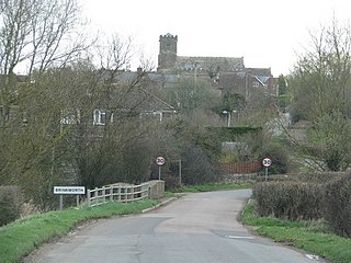
Brinkworth is a village and civil parish in northern Wiltshire, England. The village lies between Royal Wootton Bassett and Malmesbury, about 1 mile (1.6 km) north of the M4 motorway and 9 miles (14 km) west of Swindon.
Yatton Keynell is a village and civil parish in Wiltshire, England. The village is on the B4039 road near Castle Combe, about 4 miles (6 km) northwest of Chippenham, and about the same distance to the east of the county border with South Gloucestershire.

Siddington is a village and civil parish in Gloucestershire, England. It is located immediately south of Cirencester. At the 2011 United Kingdom Census, the parish had a population of 1,249.
Meysey Hampton is a village and civil parish in Gloucestershire, England, approximately 30 miles (48 km) to the south-east of Gloucester. It lies in the south of the Cotswolds, an Area of Outstanding Natural Beauty.

Miserden is a village and civil parish in Stroud District, Gloucestershire, England, 4 miles north east of Stroud. The parish includes Whiteway Colony and the hamlets of Sudgrove and The Camp. In the 2001 census the parish had a population of 420, increasing to 449 at the 2011 census.
Latton is a village and civil parish in Wiltshire, England, 1.5 miles (2.4 km) north of Cricklade, on the county border with Gloucestershire. The village is bypassed by the A419 road from Swindon to Cirencester. The parish includes the hamlet of Eysey, formerly a village with its own church and parish.

Frocester is a village and civil parish in Stroud District, Gloucestershire, England. It lies below the Cotswold escarpment, 10 miles south of Gloucester and 4 miles west of Stroud. In the 2001 census the parish had a population of 194, decreasing to 155 at the 2011 Census.

Crudwell is a village and civil parish in north Wiltshire, England. The nearest towns are Malmesbury, about 4 miles (6.4 km) to the south-west, and Cirencester, Gloucestershire 8 miles (13 km) to the north-east. Also to the north-east is Cotswold Airport. Kemble village, about 4 miles (6.4 km) away, has the nearest railway station, with services to London Paddington and Gloucester.

Poulton is a village and civil parish in the English county of Gloucestershire, approximately 24 miles (39 km) to the south-east of Gloucester. It lies in the south of the Cotswolds, an Area of Outstanding Natural Beauty. In the 2001 United Kingdom census, the parish had a population of 398, increasing to 408 at the 2011 census.

Shobrooke is a village, parish and former manor in Devon, England. The village is situated about 1 1/2 miles north-east of Crediton. It is located close to Shobrooke park. The river Shobrooke Lake flows through the village. It had a population of 537 according to the 2011 census. The name Shobrooke is derived from the old English words of succa and brōc, and translates as goblin brook.

Colesbourne is a village and civil parish in the Cotswold district of Gloucestershire, England. The village and parish lies within the Cotswolds, a designated Area of Outstanding Natural Beauty.

