Amta

Last updated

Amta
Census Town
West Bengal location map.svg
Red pog.svg
Amta
Location in West Bengal, India
India location map 3.png
Red pog.svg
Amta
Amta (India)
Coordinates: 22°34′24″N88°0′58″E / 22.57333°N 88.01611°E / 22.57333; 88.01611
CountryFlag of India.svg  India
State West Bengal
District Howrah
Population
 (2011)
  Total16,699
Languages
  Official Bengali, English
Time zone UTC+5:30 (IST)
PIN
711401
Vehicle registration WB
Website howrah.gov.in

Amta is a census town in Amta I CD Block in Uluberia subdivision of Howrah district in the Indian state of West Bengal.

Contents

Geography

Amta is located at 22°34′24″N88°0′58″E / 22.57333°N 88.01611°E / 22.57333; 88.01611 . [1]

Demographics

As per 2011 Census of India Amta had a total population of 16,699 of which 8,454 (51%) were males and 8,245 (49%) were females. Population below 6 years was 1,522. The total number of literates in Amta was 12,918 (85.12% of the population over 6 years). [2]

Transport

Since 2000 Amta is served by a broad gauge line but earlier it was served by the 45-km Howrah-Amta narrow-gauge route of the Martin's Light Railways, a private rail service established in 1892. The rail company was shut down in 1971. [3] [4] Amta railway station is part of the Kolkata Suburban Railway railway system.

Places to visit

The structure that adorns the streets of Amta is the popular Hindu Temple, Melai Chandi Mandir. Dedicated to Goddess Kali. The enclosed mandir complex is about 25 m x 35 m (approx) with four doors of each side that hosts. Gateway with office and service area, Nat mandir, an aatchala Durgeswar Shiva mandir and recently build the Ramakrishna mandir. Although it is said that this shrine is one of the fifty-one Shakti Peetha but research finds any support but it is mentioned in the Chandi-mangal of Mukundarama Chakravarti, a masterpiece of 16th-century Bengali literature. There is no such date plaque fund at the old shrine.

Udang Kalimata Ashram: popularly known as Ashram. This is a holy place situated 6 km away from Amta town. There are four well decorated temples( Kali, Shiva, Krishna, Soni) in this ashram. Nowadays, Udang Kalimata Ashram is known as one of the popular tourist spots and picnic places of Howrah district.

AMTA SWAPNA DEKHAR UJAN GANG: One of the leading voluntary organisations of Howrah district situated at Udang, Amta-i. It's a government registered voluntary organisation. They serve as a non-profit organisation to the people. They help economically backward students & distress people. Their humble effort is really appreciable. It is established by Prithishraj Kunti and Tapas Pal on 1st July, 2018.

Related Research Articles

<span class="mw-page-title-main">Kalna City</span> Town in West Bengal, India

Kalna or Ambika Kalna is a town in the Purba Bardhaman district of West Bengal, India. It is the headquarter of the Kalna subdivision, situated on the western bank of the Bhāgirathi river. The town is more popularly known as Ambika Kalna, named after the goddess Kali, Maa Ambika. It has numerous historical monuments, such as the Rajbari, and 108 Shiva temples. The city of Kalna is 60 kilometres (37 mi) from Bardhaman.

<span class="mw-page-title-main">Domjur</span> Census Town in West Bengal, India

Domjur is a census town in Domjur CD Block of Howrah Sadar subdivision in Howrah district in the Indian state of West Bengal. It is a part of Kolkata Urban Agglomeration.It is famous for its gold jewellery industries.

Eksara is a census town in Bally Jagachha CD Block of Howrah Sadar subdivision in Howrah district in the Indian state of West Bengal. It is a part of Kolkata Urban Agglomeration.

<span class="mw-page-title-main">Jagadishpur</span> Census Town in West Bengal, India

Jagadishpur is a census town in Bally Jagachha CD Block of Howrah Sadar subdivision in Howrah district in the Indian state of West Bengal. It is a part of Kolkata Urban Agglomeration.

Kantlia is a census town in Domjur CD Block of Howrah Sadar subdivision in Howrah district in the Indian state of West Bengal. It is a part of Kolkata Urban Agglomeration.

Mansinghapur is a census town in Jagatballavpur CD Block of Howrah Sadar subdivision in Howrah district in the Indian state of West Bengal. It is close to Bargachia.

<span class="mw-page-title-main">Sankrail</span> Census Town in West Bengal, India

Sankrail is a census town in Sankrail CD Block of Howrah Sadar subdivision in Howrah district in the Indian state of West Bengal. It is a part of Kolkata Urban Agglomeration.

<span class="mw-page-title-main">Singur</span> Census Town in West Bengal, India

Singur is a census town in Singur CD Block in Chandannagore subdivision of Hooghly district in the Indian state of West Bengal.

<span class="mw-page-title-main">Tarakeswar</span> City in West Bengal, India

Tarakeswar is a famous sacred city and a municipality in Hooghly district in the Indian state of West Bengal. Tarakeswar is called "Baba Dham" or "The city of Shiva". It is one of the major tourist and holy place of West Bengal as well as India. Tarakeswar is a place of pilgrimage of Lord Shiva sect in West Bengal 58 kilometres (36 mi) away from State Capital Kolkata and about 1,520 kilometres away from National Capital New Delhi. Tarakeswar can be reached conveniently by train and bus from various places of West Bengal. Tarakeswar Station is well connected by Howrah Station. This city is also famous for agriculture, Tarakeswar's potato is also famous in all over India.

<span class="mw-page-title-main">Antpur</span> Village in West Bengal, India

Antpur is a village in the Jangipara community development block of the Srirampore subdivision in the Hooghly District in the Indian state of West Bengal. It is around 20 km from Tarakeswar. Haripal is nearest railway station from Antpur.

<span class="mw-page-title-main">Uluberia subdivision</span> Subdivision in West Bengal, India

Uluberia subdivision is a subdivision of the Howrah district in the state of West Bengal, India. It consists of Uluberia municipality and nine community development (CD) blocks, including 90 gram panchayats and six census towns. The six census towns are: Khalor, Bagnan, Naupala, Santoshpur, Balaram Pota and Uttar Pirpur. The subdivision has its headquarters at Uluberia. The whole division forms the Lok Sabha constituency of Uluberia.

<span class="mw-page-title-main">Amta I</span> Historical City in West Bengal, India

Amta I is a city and community development block that forms an administrative division in Uluberia subdivision of Howrah district in the Indian state of West Bengal.

<span class="mw-page-title-main">Jagatballavpur (community development block)</span> Community development block in West Bengal, India

Jagatballavpur is a community development block that forms an administrative division in Howrah Sadar subdivision of Howrah district in the Indian state of West Bengal.

<span class="mw-page-title-main">Bagnan I</span> Community development block in West Bengal, India

Bagnan I is a community development block that forms an administrative division in Uluberia subdivision of Howrah district in the Indian state of West Bengal.

Champadanga is a town in Tarakeswar CD Block in Chandannagore subdivision of Hooghly district in the Indian state of West Bengal.

<span class="mw-page-title-main">Jangipara (community development block)</span> Community development block in West Bengal, India

Jangipara is a community development block that forms an administrative division in Srirampore subdivision of Hooghly district in the Indian state of West Bengal.

Masagram is a village in Ajhapur gram panchayat of Jamalpur CD block in Bardhaman Sadar South subdivision of Purba Bardhaman district in the Indian state of West Bengal.

<span class="mw-page-title-main">Haripal</span> Village in West Bengal, India

Haripal is a village in Haripal CD Block in Chandannagore subdivision of Hooghly district in the Indian state of West Bengal.
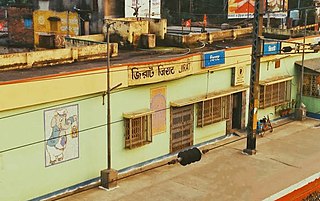
<span class="mw-page-title-main">Jagatballavpur</span> Census Town in West Bengal, India

Jagatballavpur is a census town in Jagatballavpur CD Block in Howrah Sadar subdivision of Howrah district in the Indian state of West Bengal.

<span class="mw-page-title-main">Amta II</span> Community development block in West Bengal, India

Amta II is a community development block that forms an administrative division in Uluberia subdivision of Howrah district in the Indian state of West Bengal.

References

  1. "Amta Bus Stand (Amta)". West Bengal. Wikimapia. Retrieved 15 May 2016.
  2. "C.D. Block Wise Primary Census Abstract Data(PCA)". 2011 census: West Bengal – District-wise CD Blocks. Registrar General and Census Commissioner, India. Retrieved 11 May 2016.
  3. "Next weekend you can be at ... Antpur". The Telegraph, 24 July 2005. Archived from the original on 12 September 2012. Retrieved 19 January 2009.
  4. "Howrah-Amta BG line section inaugurated". The Hindu Business Line, 24 July 2000. Retrieved 19 January 2009.