Anderson's theory of faulting

Last updated
Types of faulting Faults6.png
Types of faulting

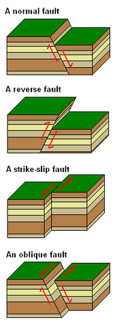
Anderson's theory of faulting, devised by Ernest Masson Anderson in 1905, is a way of classifying geological faults by use of principal stress. [1] [2] A fault is a fracture in the surface of the Earth that occurs when rocks break under extreme stress. [3] Movement of rock along the fracture occurs in faults. If no movement occurs, the fracture is described instead as a joint. The grinding of two rock masses against each another along a fault results in an earthquake and deformation of the Earth's crust. [4] Faults can be classified into four types based on the kind of motion between the separated rock masses: normal, reverse, strike-slip, and oblique.

Contents

Types of faults

While there are four types of faults classified by geologists today, Anderson's fault theory focuses on the explanation of three: normal, reverse, and strike-slip. Slip is known as the distance a plate has moved along the other. Because it cannot be known if one or both plates moved in the faulting process, this distance is classified as the distance one plate has moved relative to the other. Dip is defined as the angle of the fault relative to the surface of the earth, which indicates the plane on which slip will occur. Lastly, in any horizontal fault, the wall partially above the fault is called hanging wall, while the wall partially below the fault is called the footwall. [4]

Normal and reverse dip-slip faults with labeled hanging wall and footwall Nor rev.png
Normal and reverse dip-slip faults with labeled hanging wall and footwall

Normal faults

Normal faults, a type of dip-slip faults, occur when the hanging wall slips down the dip plane. They usually occur in response to tension creating the fracture and the following extension of the plane. See animation here [5]

Reverse faults

Reverse faults are also known as thrust faults and are also another type of dip-slip faults. In this case, the hanging wall slips up the dip plane. Contrary to normal faults, these are caused by compression of the plane. See animation here [5]

Strike-Slip faults

Lateral strike-slip faults Strike slip fault.png
Lateral strike-slip faults

Strike-slip faults occur when the blocks slide against each other laterally, parallel to the plane. The direction of the slip can be observed from either side of the fault, with the far block moving to the left indicating a left lateral slip, and the converse indicating a right lateral slip. See animation here [5]

Oblique faults

Oblique faults combine the vertical movement of dip-slip faults and lateral movement of strike-slip faults. They must have significant dip and strike components to be considered oblique. Anderson's fault theory does not consider oblique faults separately as they are a combination of already defined faults. [5] Additionally, oblique faults do not obey Anderson's theory as they do follow the same scheme of principal stresses as the other fault types.

Theory and principal stresses


Stress

In geology, stress is defined as a force applied to a material. There are 4 types of stresses that rocks are subject to. First of which is when rock is pushed down by the weight of all the rocks above it, preventing it from moving. This is called confining stress and is predominant deep beneath the Earth's surface. The second type is compression. This occurs when rocks are squeezed together causing them to fold or fracture. While confining stress and compression stress both deal with rocks in a state of compression, the difference lies in that confining stress is a vertical stress, making it influenced by gravity. On the other hand, compression stress acts horizontally, parallel to the surface of the earth. Tension stress causes rocks to be pulled apart and is associated with the lengthening of a surface. Shear stress acts in the direction against motion as two parallel planes move against one another. [4]

Principal stress

In Anderson's fault theory, the earth's surface is considered to be a collection of horizontal segments that connect to comprise one plane which experiences no shear stress parallel to itself. [6] With zero shear stress, all other stress directions are maximized or minimized, making them principal stresses, normal to the principal planes. The theory models faulting in terms of these three principal stresses denoted as σ₁, σ₂, and σ₃. Two of these stresses are horizontal, on the plane, and one is vertical, normal to the plane. [2] All principal stresses are perpendicular to one another. Using geologic convention, σ₁ always indicates the dominant stress in any fault; therefore, it will be the stress that causes motion. σ₃ is the stress that directly opposes the motion caused by σ₁, therefore is the weakest principal stress. σ₂ is perpendicular to both σ₁ and σ₃ and in the cases of dip-slip and strike-slip faults will cause no motion in its direction, making it the second strongest principal stress. [2]

Principal stresses and fault regimes

Anderson's theory classifies tectonic environments into three fault regimes based on their relationship with the principal stresses. σ₁ being the vertical stress is classified as a gravity regime because movement aligns with the force of gravity. This regime dominated by normal dip-slip faults. A vertical σ₃ is classified as a thrust regime. These are dominated by reverse dip-slip faults with σ₁ once again parallel to motion. The third regime is characterized by a vertical σ₂ and dominated by both left lateral and right lateral strike-slip faults. [2]

Observed normal fault dip angle Andersons Fault Model.png
Observed normal fault dip angle

Applications

Anderson's fault theory also presents a model for seismic interpretation. [7] This model predicts the dip of faults according to their regime classification. [2] Conjugate walls in any fault will share a dip angle with that angle being measured from the top of the hanging wall or the bottom of the foot wall. [2] Gravity regimes are predicted to have a 60° dip, while thrust regimes have a dip angle of 30°. Wrench regimes have a 90° dip as there is no hanging wall. [7] When approaching a fault of an unknown type, these prediction can be used to probable classification of the fault. Furthermore, when the type of the fault is known, actual measurements of dip can be compared to the predictions from Anderson's fault theory and reveal more about the geological landscape. For example, a normal fault with a dip observed to be not 60° would indicate the rotation of the plates which could indicate the presence of anisotropic materials, such as a salt layer, or a plane of weakness, which would indicate higher chances of geologic activity in that area in the future.

Related Research Articles

<span class="mw-page-title-main">Earthquake</span> Sudden movement of the Earths crust

An earthquake – also called a quake, tremor, or temblor – is the shaking of the surface of Earth resulting from a sudden release of energy in the lithosphere that creates seismic waves. Earthquakes can range in intensity, from those that are so weak that they cannot be felt, to those violent enough to propel objects and people into the air, damage critical infrastructure, and wreak destruction across entire cities. The seismic activity of an area is the frequency, type, and size of earthquakes experienced over a particular time. The seismicity at a particular location in the Earth is the average rate of seismic energy release per unit volume. The word tremor is also used for non-earthquake seismic rumbling.

<span class="mw-page-title-main">Structural geology</span> Science of the description and interpretation of deformation in the Earths crust

Structural geology is the study of the three-dimensional distribution of rock units with respect to their deformational histories. The primary goal of structural geology is to use measurements of present-day rock geometries to uncover information about the history of deformation (strain) in the rocks, and ultimately, to understand the stress field that resulted in the observed strain and geometries. This understanding of the dynamics of the stress field can be linked to important events in the geologic past; a common goal is to understand the structural evolution of a particular area with respect to regionally widespread patterns of rock deformation due to plate tectonics.

<span class="mw-page-title-main">Transform fault</span> Plate boundary where the motion is predominantly horizontal

A transform fault or transform boundary, is a fault along a plate boundary where the motion is predominantly horizontal. It ends abruptly where it connects to another plate boundary, either another transform, a spreading ridge, or a subduction zone. A transform fault is a special case of a strike-slip fault that also forms a plate boundary.

<span class="mw-page-title-main">Fault (geology)</span> Fracture or discontinuity in rock across which there has been displacement

In geology, a fault is a planar fracture or discontinuity in a volume of rock across which there has been significant displacement as a result of rock-mass movements. Large faults within Earth's crust result from the action of plate tectonic forces, with the largest forming the boundaries between the plates, such as the megathrust faults of subduction zones or transform faults. Energy release associated with rapid movement on active faults is the cause of most earthquakes. Faults may also displace slowly, by aseismic creep.

<span class="mw-page-title-main">Shear zone</span> Structural discontinuity surface in the Earths crust and upper mantle

In geology, a shear zone is a thin zone within the Earth's crust or upper mantle that has been strongly deformed, due to the walls of rock on either side of the zone slipping past each other. In the upper crust, where rock is brittle, the shear zone takes the form of a fracture called a fault. In the lower crust and mantle, the extreme conditions of pressure and temperature make the rock ductile. That is, the rock is capable of slowly deforming without fracture, like hot metal being worked by a blacksmith. Here the shear zone is a wider zone, in which the ductile rock has slowly flowed to accommodate the relative motion of the rock walls on either side.

<span class="mw-page-title-main">Mendocino Triple Junction</span> Point where the Gorda plate, the North American plate, and the Pacific plate meet

The Mendocino Triple Junction (MTJ) is the point where the Gorda plate, the North American plate, and the Pacific plate meet, in the Pacific Ocean near Cape Mendocino in northern California. This triple junction is the location of a change in the broad plate motions which dominate the west coast of North America, linking convergence of the northern Cascadia subduction zone and translation of the southern San Andreas Fault system. This region is can be characterized by transform fault movement, the San Andreas also by transform strike slip movement, and the Cascadia subduction zone by a convergent plate boundary subduction movement. The Gorda plate is subducting, towards N50ºE, under the North American plate at 2.5 – 3 cm/yr, and is simultaneously converging obliquely against the Pacific plate at a rate of 5 cm/yr in the direction N115ºE. The accommodation of this plate configuration results in a transform boundary along the Mendocino Fracture Zone, and a divergent boundary at the Gorda Ridge. This area is tectonically active historically and today. The Cascadia subduction zone is known to be capable of producing megathrust earthquakes on the order of MW 9.0.

<span class="mw-page-title-main">Vein (geology)</span> Sheetlike body of crystallized minerals within a rock

In geology, a vein is a distinct sheetlike body of crystallized minerals within a rock. Veins form when mineral constituents carried by an aqueous solution within the rock mass are deposited through precipitation. The hydraulic flow involved is usually due to hydrothermal circulation.

<span class="mw-page-title-main">Shear (geology)</span> Response of rock to deformation

In geology, shear is the response of a rock to deformation usually by compressive stress and forms particular textures. Shear can be homogeneous or non-homogeneous, and may be pure shear or simple shear. Study of geological shear is related to the study of structural geology, rock microstructure or rock texture and fault mechanics.

<span class="mw-page-title-main">Joint (geology)</span> Type of fracture in rock

A joint is a break (fracture) of natural origin in a layer or body of rock that lacks visible or measurable movement parallel to the surface (plane) of the fracture. Although joints can occur singly, they most frequently appear as joint sets and systems. A joint set is a family of parallel, evenly spaced joints that can be identified through mapping and analysis of their orientations, spacing, and physical properties. A joint system consists of two or more intersecting joint sets.

The Lewis Overthrust is a geologic thrust fault structure of the Rocky Mountains found within the bordering national parks of Glacier in Montana, United States and Waterton Lakes in Alberta, Canada. The structure was created due to the collision of tectonic plates about 59-75 million years ago that drove a several mile thick wedge of Precambrian rock 50 mi (80 km) eastwards, causing it to overlie softer Cretaceous age rock that is 1300 to 1400 million years younger.

<span class="mw-page-title-main">Fracture (geology)</span> Geologic discontinuity feature, often a joint or fault

A fracture is any separation in a geologic formation, such as a joint or a fault that divides the rock into two or more pieces. A fracture will sometimes form a deep fissure or crevice in the rock. Fractures are commonly caused by stress exceeding the rock strength, causing the rock to lose cohesion along its weakest plane. Fractures can provide permeability for fluid movement, such as water or hydrocarbons. Highly fractured rocks can make good aquifers or hydrocarbon reservoirs, since they may possess both significant permeability and fracture porosity.

Strike-slip tectonics or wrench tectonics is a type of tectonics that is dominated by lateral (horizontal) movements within the Earth's crust. Where a zone of strike-slip tectonics forms the boundary between two tectonic plates, this is known as a transform or conservative plate boundary. Areas of strike-slip tectonics are characterised by particular deformation styles including: stepovers, Riedel shears, flower structures and strike-slip duplexes. Where the displacement along a zone of strike-slip deviates from parallelism with the zone itself, the style becomes either transpressional or transtensional depending on the sense of deviation. Strike-slip tectonics is characteristic of several geological environments, including oceanic and continental transform faults, zones of oblique collision and the deforming foreland of zones of continental collision.

<span class="mw-page-title-main">Fault trace</span> Intersection of a geological fault with the Earths surface

A fault trace describes the intersection of a geological fault with the Earth's surface, which leaves a visible disturbance on the surface, usually looking like a crack in the surface with jagged rock structures protruding outward. The term also applies to a line plotted on a geological map to represent a fault. These fractures tend to occur when a slip surface expands from a fault core, especially during an earthquake. This tends to occur with fault displacement, in which surfaces on both sides of a fault, known as fault blocks, separate horizontally or vertically.

<span class="mw-page-title-main">Focal mechanism</span> Process that generates seismic waves in an earthquake

The focal mechanism of an earthquake describes the deformation in the source region that generates the seismic waves. In the case of a fault-related event, it refers to the orientation of the fault plane that slipped, and the slip vector and is also known as a fault-plane solution. Focal mechanisms are derived from a solution of the moment tensor for the earthquake, which itself is estimated by an analysis of observed seismic waveforms. The focal mechanism can be derived from observing the pattern of "first motions", whether the first arriving P waves break up or down. This method was used before waveforms were recorded and analysed digitally, and this method is still used for earthquakes too small for easy moment tensor solution. Focal mechanisms are now mainly derived using semi-automatic analysis of the recorded waveforms.

In geology, a basin is a region where subsidence generates accommodation space for the deposition of sediments. A pull-apart basin is a structural basin where two overlapping strike-slip faults or a fault bend creates an area of crustal extension undergoing tension, which causes the basin to sink down. Frequently, the basins are rhombic or sigmoidal in shape. Dimensionally, basins are limited to the distance between the faults and the length of overlap. Pull-apart basins are also referred to as overlapping-tension-zones (OTZ).

In structural geology, strain partitioning is the distribution of the total strain experienced on a rock, area, or region, in terms of different strain intensity and strain type. This process is observed on a range of scales spanning from the grain – crystal scale to the plate – lithospheric scale, and occurs in both the brittle and plastic deformation regimes. The manner and intensity by which strain is distributed are controlled by a number of factors listed below.

Paleostress inversion refers to the determination of paleostress history from evidence found in rocks, based on the principle that past tectonic stress should have left traces in the rocks. Such relationships have been discovered from field studies for years: qualitative and quantitative analyses of deformation structures are useful for understanding the distribution and transformation of paleostress fields controlled by sequential tectonic events. Deformation ranges from microscopic to regional scale, and from brittle to ductile behaviour, depending on the rheology of the rock, orientation and magnitude of the stress, etc. Therefore, detailed observations in outcrops, as well as in thin sections, are important in reconstructing the paleostress trajectories.

Kapuni is an onshore natural gas-condensate field located in the Taranaki Basin, a ~100,000 km2 partially-inverted rift basin on the Taranaki Peninsula in the North Island, New Zealand. Discovered in 1959 and brought into production in 1970, Kapuni remained New Zealand's only producing gas-condensate field until the offshore Maui gas field began production in 1979.

The 1983 Kaoiki earthquake struck southern Hawaii Island on the morning of November 16, 1983. Measuring Mw  6.7, it was the largest to hit the island since 1975. The epicenter was located 50 km southeast of Hilo with an approximated depth of 12 km. The shallow strike-slip earthquake was assigned a maximum intensity of IX (Violent) on the Modified Mercalli scale. 6 people were injured, widespread damage and landslides were reported across the island.

Magmatism along strike-slip faults is the process of rock melting, magma ascent and emplacement, associated with the tectonics and geometry of various strike-slip settings, most commonly occurring along transform boundaries at mid-ocean ridge spreading centres and at strike-slip systems parallel to oblique subduction zones. Strike-slip faults have a direct effect on magmatism. They can either induce magmatism, act as a conduit to magmatism and magmatic flow, or block magmatic flow. In contrast, magmatism can also directly impact on strike-slip faults by determining fault formation, propagation and slip. Both magma and strike-slip faults coexist and affect one another.

References

  1. "CWU Geological Sciences - Geology 360 - Structural Geology". www.geology.cwu.edu. Retrieved 2021-10-21.
  2. 1 2 3 4 5 6 Waldron, John; Snyder, Morgan (2020). "L. Tectonic Environments of Faulting".{{cite journal}}: Cite journal requires |journal= (help)
  3. "USGS.gov | Science for a changing world". www.usgs.gov. Retrieved 2021-10-21.
  4. 1 2 3 "Stress and Strain | Geology". courses.lumenlearning.com. Retrieved 2021-10-21.
  5. 1 2 3 4 "7.3: Stress in Earth's Crust". Geosciences LibreTexts. 2017-01-13. Retrieved 2021-10-21.
  6. Célérier, Bernard (2008). "Seeking Anderson's faulting in seismicity: A centennial celebration". Reviews of Geophysics. 46 (4). doi: 10.1029/2007RG000240 . ISSN   1944-9208. S2CID   128686064.
  7. 1 2 JONES, O. T. (June 1942). "The Dynamics of Faulting and Dyke Formation: with Applications to Britain". Nature. 149 (3789): 651–652. doi:10.1038/149651b0. ISSN   0028-0836. S2CID   4100051.