
Bergen County is the most populous county in the U.S. state of New Jersey. Located in the northeastern corner of New Jersey, Bergen County and its many inner suburbs constitute a highly developed part of the New York City metropolitan area, bordering the Hudson River; the George Washington Bridge, which crosses the Hudson, connects Bergen County with Manhattan. The county lies in the Gateway Region of North Jersey.

Route 3 is a state highway in the northeastern part of New Jersey. The route runs 10.84 miles (17.45 km) from U.S. Route 46 (US 46) in Clifton, Passaic County, to US 1/9 in North Bergen, Hudson County. The route intersects many major roads, including US 46, which takes travelers to Interstate 80 (I-80) west for commuting out of the city-area, the Garden State Parkway and Route 21 in Clifton, Route 17 and the Western Spur of the New Jersey Turnpike (I-95) in East Rutherford, the Eastern Spur of the New Jersey Turnpike in Secaucus, and Route 495 in North Bergen, for traffic going to the Lincoln Tunnel into New York City. Route 3 serves as the main artery to the Lincoln Tunnel from I-80, in conjunction with a portion of US 46 and Route 495. Portions of the route are not up to freeway standards; with driveways serving businesses and bus stops. Despite this, many construction projects have been underway over the years to alleviate this issue. Route 3 also provided access to Hoffmann La Roche's former American headquarters in Nutley, the Meadowlands Sports Complex and American Dream in East Rutherford. The road inspired a story in The New Yorker in 2004 by Ian Frazier due to its views of the Manhattan skyline. Route 3 was originally the Lincoln Tunnel Approach and ended at the state line in the Hudson River, though it was scaled back following the construction of I-495; which is now Route 495 due to also not meeting interstate highway standards.

Route 4 is a state highway in Bergen County and Passaic County, United States. The highway stretches 10.83 mi (17.43 km) from Route 20 in Paterson east to an interchange with Interstate 95 (I-95), U.S. Route 1/9 (US 1/9), US 46, and US 9W at the George Washington Bridge approach in Fort Lee.

Route 5 is a 3.18-mile (5.12 km) state highway located entirely in Bergen County, New Jersey, United States. It runs from U.S. Route 1/9 (US 1-9) in Ridgefield east down the New Jersey Palisades to end at County Route 505 at the Hudson River in Edgewater, forming a “wavy” path. The route is a two- to four-lane undivided highway its entire length, passing mostly through wooded residential neighborhoods. The route passes under Route 63 in Palisades Park, with access to that route provided by Bergen Boulevard, and intersects the southern terminus of Route 67 in Fort Lee.

Route 17 is a state highway in Bergen County, New Jersey, United States, that provides a major route from the George Washington Bridge, Lincoln Tunnel and other northeast New Jersey points to the New York State Thruway at Suffern, New York. It runs 27.20 mi (43.77 km) from an intersection with Route 7 and County Route 507 (CR 507) in North Arlington north to the New York state line along Interstate 287 (I-287) in Mahwah, where New York State Route 17 (NY 17) continues into New York. Between Route 7 and Route 3 in Rutherford, Route 17 serves as a local road. From Route 3 north to the junction with U.S. Route 46 (US 46) in Hasbrouck Heights, the road is an arterial road with jughandles. The portion of Route 17 from US 46 to I-287 near the state line in Mahwah is a four- to six-lane arterial with all cross traffic handled by interchanges, and many driveways and side streets accessed from right-in/right-out ramps from the right lane. For three miles (5 km) north of Route 4, well over a hundred retail stores and several large shopping malls line the route in the borough of Paramus. The remainder of this portion of Route 17 features lighter suburban development. The northernmost portion of Route 17 in Mahwah runs concurrently with I-287 to the New York state line.
Teaneck is a township in Bergen County, in the U.S. state of New Jersey. It is a bedroom community in the New York metropolitan area. As of the 2020 United States census, the township's population was 41,246, an increase of 1,470 (+3.7%) from the 2010 census count of 39,776, which in turn reflected an increase of 516 (+1.3%) from the 39,260 counted in the 2000 census. As of 2020, Teaneck was the second-most populous among the 70 municipalities in Bergen County, behind Hackensack, which had a population of 46,030.

Hackensack is the most populous municipality and the county seat of Bergen County, in the U.S. state of New Jersey. The area was officially named New Barbadoes Township until 1921, but has informally been known as Hackensack since at least the 18th century. As of the 2020 United States census, the city's population was 46,030, its highest decennial count ever and an increase of 3,020 (+7.0%) from the 2010 census count of 43,010, which in turn reflected an increase of 333 (+0.8%) from the 42,677 counted in the 2000 census.

New Jersey Transit Corporation, branded as NJ Transit or NJTransit and often shortened to NJT, is a state-owned public transportation system that serves the U.S. state of New Jersey and portions of the states of New York and Pennsylvania. It operates buses, light rail, and commuter rail services throughout the state, connecting to major commercial and employment centers both within the state and in its two adjacent major cities, New York City and Philadelphia. In 2023, the system had a ridership of 209,259,800.

New Bridge Landing, signed as New Bridge Landing at River Edge, is an active commuter railroad station in the borough of River Edge, Bergen County, New Jersey. Located at the junction of Kinderkamack Road and Grand Avenue and next to Route 4, the station is serviced by Pascack Valley Line trains running between Hoboken Terminal in Hoboken and Spring Valley station in the eponymous village in Rockland County, New York. The next station to the north is the eponymous River Edge and the next station to the south is Anderson Street in Hackensack. The station contains a single low-level side platform on the southbound side of the track, resulting in the station not being accessible for handicapped persons per the Americans with Disabilities Act of 1990.
Interstate 80 (I-80) is a major interstate highway in the United States, running from San Francisco, California, eastward to the New York metropolitan area. In New Jersey, I-80 runs for 68.3 miles (109.9 km) from the Delaware Water Gap Toll Bridge at the Pennsylvania state line to its eastern terminus at the interchange with the New Jersey Turnpike (I-95) in Teaneck, Bergen County. I-95 continues from the end of I-80 to the George Washington Bridge for access to New York City. The highway runs parallel to US 46 through rural areas of Warren and Sussex counties before heading into more suburban surroundings in Morris County. As the road continues into Passaic and Bergen counties, it heads into more urban areas. The New Jersey Department of Transportation identifies I-80 within the state as the Christopher Columbus Highway.

Bayfront is an urban redevelopment project in Jersey City, New Jersey.

Hackensack River Greenway, once known as the Hackensack RiverWalk, a is partially constructed greenway along the Newark Bay and Hackensack River in Hudson County, New Jersey, United States.

The Passaic–Bergen–Hudson Transit Project is a project under study by NJ Transit to reintroduce passenger service on a portion of the New York, Susquehanna and Western Railway (NYSW) right-of-way (ROW) in Passaic, Bergen and Hudson counties using newly built, FRA-compliant diesel multiple unit rail cars. Plans call for service to run from Hawthorne south through Paterson, east to Hackensack and then southeast to North Bergen, where it would join the Hudson-Bergen Light Rail (HBLR).
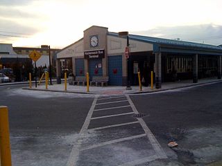
Hackensack Bus Terminal, also called the Hackensack Bus Transfer, is a regional bus station in downtown Hackensack, New Jersey, owned and operated by New Jersey Transit. The bus station was built in the 1970s and was extensively renovated in 2007 while starting in 2006. An outdoor central island boarding–disembarking area surrounds an indoor waiting room and ticketing facilities. Service from nearby bus stops travels to locations in Bergen, Passaic, Essex and Hudson counties as well as the Port Authority Bus Terminal and George Washington Bridge Bus Station in New York City. In October 2018, the Hackensack Transit Connector, servicing the bus terminal, the city's train stations, and the County Courthouse Complex, was initiated.

The George Washington Bridge Plaza, also known as GWB Plaza or Bridge Plaza, is the convergence of roads and highways around the site of the George Washington Bridge toll plaza in Fort Lee, New Jersey, United States. The plaza is located north of and parallel to Fort Lee's Main Street. The surrounding busy area is characterized by a mix of commercial and residential uses and an architectural variety that includes parking lots, strip malls, houses, gas stations, mid-rise office buildings and high-rise condominiums. Just to the east is Fort Lee Historic Park, Palisades Interstate Park and the bridge's western tower.

Bus rapid transit (BRT) in New Jersey comprises limited-stop bus service, exclusive bus lanes (XBL) and bus bypass shoulders (BBS). Under the banner Next Generation Bus NJ Transit (NJT), the New Jersey Department of Transportation (NJDOT), and the metropolitan planning organizations of New Jersey (MPO) which recommend and authorize transportation projects are undertaking the creation of several additional BRT systems in the state.
Kingsland Avenue Bridge, earlier known as Avondale Bridge and designated the De Jessa Memorial Bridge, is a vehicular movable bridge over the Passaic River in northeastern New Jersey. It crosses the county line to connect the towns of Lyndhurst in Bergen and Nutley in Essex, originally taking its name from the Kingsland section. The bridge is 10.7 miles (17.2 km) from the river's mouth at Newark Bay, and is required to open on four hours' notice. As of 2010, there were 26,420 daily crossings of the bridge, which provides one lane in each direction.

Little Ferry Yard is a railyard and intermodal terminal in the Port of New York and New Jersey served by the CSX River Subdivision (CSXT), New York, Susquehanna and Western Railway (NYSW), Norfolk Southern Railway and Conrail Shared Assets Operations (CRCX).

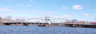
Midtown Bridge, also known as the Salem Street Bridge and William C. Ryan Memorial Bridge, crosses over the Hackensack River between Hackensack and Bogota, in Bergen County, New Jersey, United States. The through truss bridge was originally a swing bridge built in 1900 for trolleys. It became a road bridge in 1940 and its swing span was fixed in 1984. It was closed in 2017 and slated for replacement; the rebuilt bridge reopened in April 2018.

