Related Research Articles

In geography, latitude is a coordinate that specifies the north–south position of a point on the surface of the Earth or another celestial body. Latitude is given as an angle that ranges from –90° at the south pole to 90° at the north pole, with 0° at the Equator. Lines of constant latitude, or parallels, run east–west as circles parallel to the equator. Latitude and longitude are used together as a coordinate pair to specify a location on the surface of the Earth.

Longitude is a geographic coordinate that specifies the east–west position of a point on the surface of the Earth, or another celestial body. It is an angular measurement, usually expressed in degrees and denoted by the Greek letter lambda (λ). Meridians are semicircular lines running from pole to pole that connect points with the same longitude. The prime meridian defines 0° longitude; by convention the International Reference Meridian for the Earth passes near the Royal Observatory in Greenwich, England on the island of Great Britain. Positive longitudes are east of the prime meridian, and negative ones are west.

The Mercator projection is a cylindrical map projection presented by Flemish geographer and cartographer Gerardus Mercator in 1569. It became the standard map projection for navigation because it is unique in representing north as up and south as down everywhere while preserving local directions and shapes. The map is thereby conformal. As a side effect, the Mercator projection inflates the size of objects away from the equator. This inflation is very small near the equator but accelerates with increasing latitude to become infinite at the poles. As a result, landmasses such as Greenland and Antarctica appear far larger than they actually are relative to landmasses near the equator, such as Central Africa.

The geographic coordinate system (GCS) is a spherical or ellipsoidal coordinate system for measuring and communicating positions directly on the Earth as latitude and longitude. It is the simplest, oldest and most widely used of the various of spatial reference systems that are in use, and forms the basis for most others. Although latitude and longitude form a coordinate tuple like a cartesian coordinate system, the geographic coordinate system is not cartesian because the measurements are angles and are not on a planar surface.

In cartography, map projection is the term used to describe a broad set of transformations employed to represent the two-dimensional curved surface of a globe on a plane. In a map projection, coordinates, often expressed as latitude and longitude, of locations from the surface of the globe are transformed to coordinates on a plane. Projection is a necessary step in creating a two-dimensional map and is one of the essential elements of cartography.

The Adams–Onís Treaty of 1819, also known as the Transcontinental Treaty, the Florida Purchase Treaty, or the Florida Treaty, was a treaty between the United States and Spain in 1819 that ceded Florida to the U.S. and defined the boundary between the U.S. and New Spain. It settled a standing border dispute between the two countries and was considered a triumph of American diplomacy. It came in the midst of increasing tensions related to Spain's territorial boundaries in North America against the United States and the United Kingdom in the aftermath of the American Revolution; it also came during the Latin American wars of independence.

The Greater East Asia Co-Prosperity Sphere, also known as the GEACPS, was a concept that was developed in the Empire of Japan and propagated to Asian populations which were occupied by it from 1931 to 1945, and which officially aimed at creating a self-sufficient bloc of Asian nations that would be led by the Japanese and be free from the rule of Western powers. The idea was first announced on 1 August 1940 in a radio address delivered by Foreign Minister Yōsuke Matsuoka.

The Gilbert and Ellice Islands in the Pacific Ocean were part of the British Empire from 1892 to 1976. They were a protectorate from 1892 to 12 January 1916, and then a colony until 1 January 1976. The history of the colony was mainly characterized by phosphate mining on Ocean Island. In October 1975, these islands were divided by force of law into two separate colonies, and they became independent nations shortly thereafter: the Ellice Islands became Tuvalu in 1978, and the Gilbert Islands became part of Kiribati in 1979.

German New Guinea consisted of the northeastern part of the island of New Guinea and several nearby island groups and was the first part of the German colonial empire. The mainland part of the territory, called Kaiser-Wilhelmsland, became a German protectorate in 1884. Other island groups were added subsequently. The Bismarck Archipelago, and the North Solomon Islands were declared a German protectorate in 1885; in the same year the Marshall Islands were bought from Spain for $4.5 million by the Hispano-German Protocol of Rome; Nauru was annexed to the Marshall Islands protectorate in 1888, and finally the Caroline Islands, Palau, and the Mariana Islands were bought from Spain in 1899. German Samoa, though part of the German colonial empire, was not part of German New Guinea.

The Bechuanaland Protectorate was a protectorate established on 31 March 1885, by the United Kingdom of Great Britain and Ireland in Southern Africa. It became the Republic of Botswana on 30 September 1966.

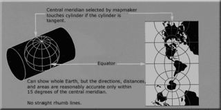
The transverse Mercator map projection is an adaptation of the standard Mercator projection. The transverse version is widely used in national and international mapping systems around the world, including the Universal Transverse Mercator. When paired with a suitable geodetic datum, the transverse Mercator delivers high accuracy in zones less than a few degrees in east-west extent.
The 42nd parallel north is a circle of latitude that is 42 degrees north of the Earth's equatorial plane. It crosses Europe, the Mediterranean Sea, Asia, the Pacific Ocean, North America, and the Atlantic Ocean.

The scale of a map is the ratio of a distance on the map to the corresponding distance on the ground. This simple concept is complicated by the curvature of the Earth's surface, which forces scale to vary across a map. Because of this variation, the concept of scale becomes meaningful in two distinct ways.

The South Seas Mandate, officially the Mandate for the German Possessions in the Pacific Ocean Lying North of the Equator, was a League of Nations mandate in the "South Seas" given to the Empire of Japan by the League of Nations following World War I. The mandate consisted of islands in the north Pacific Ocean that had been part of German New Guinea within the German colonial empire until they were occupied by Japan during World War I. Japan governed the islands under the mandate as part of the Japanese colonial empire until World War II, when the United States captured the islands. The islands then became the United Nations–established Trust Territory of the Pacific Islands governed by the United States. The islands are now part of Palau, Northern Mariana Islands, Federated States of Micronesia, and Marshall Islands.

The Treaty of Rarotonga is the common name for the South Pacific Nuclear Free Zone Treaty, which formalises a nuclear-weapon-free zone in the South Pacific. The treaty bans the use, testing, and possession of nuclear weapons within the borders of the zone.
A colonial empire is a collective of territories, either contiguous with the imperial center or located overseas, settled by the population of a certain state and governed by that state.

Sedudu Island is a fluvial island in the Chobe River, in Botswana adjacent to the border with Namibia. The island was the subject of a territorial dispute between these countries, resolved by a 1999 ruling of the International Court of Justice (ICJ) that the border runs down the thalweg of the river immediately north of the island. The island is approximately 5 square kilometres in area, with no permanent residents. For several months each year, beginning around March, the island is submerged by floods. The Island is one of the top tourist attractions in Chobe.

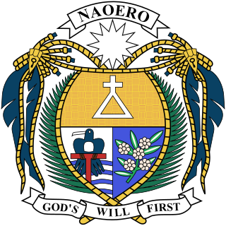
Nauruan nationality law is regulated by the 1968 Constitution of Nauru, as amended; the Naoero Citizenship Act of 2017, and its revisions; custom; and international agreements entered into by the Nauruan government. These laws determine who is, or is eligible to be, a national of Nauru. The legal means to acquire nationality, formal membership in a nation, differ from the domestic relationship of rights and obligations between a national and the nation, known as citizenship. Nauruan nationality is typically obtained either on the principle of jus soli, i.e. by birth in the Nauru or under the rules of jus sanguinis, i.e. by birth to parents with Nauruan nationality. It can be granted to persons with an affiliation to the country who has lived in the country for a given period of time through naturalization.
The meridian 90° west of Greenwich is a line of longitude that extends from the North Pole across the Arctic Ocean, North America, the Gulf of Mexico, Central America, the Pacific Ocean, the Southern Ocean, and Antarctica to the South Pole.

Queensland is the north-eastern state of Australia and has land borders with three other Australian states and territories: New South Wales, South Australia and Northern Territory. To the north of Queensland is the Torres Strait separating the Australian mainland from Papua New Guinea. To the east of Queensland is the Coral Sea, part of the Pacific Ocean. There are many islands off the Queensland coast which form part of the state of Queensland.
References
- ↑ Sydney Morning Herald, 7 February 1883, summary of an article in the Augsburger Allgemeine Zeitung, 27 November 1882
- 1 2 Fabricius 1992 (see External links), p. 167
- ↑ Fabricius 1992, p. 168
- 1 2 Fabricius 1992, p. 131-132
- ↑ Fabricius 1992, p. 134-136
- ↑ "Kiribati And Tuvalu Protectorates".
- ↑ Nauru: Introduction, CIA World Factbook, retrieved Jan 15, 2017