
Protected areas of South Australia, consisting of protected areas located within South Australia and its immediate onshore waters and which are managed by South Australian Government agencies. As of 2018, South Australia contained 359 separate protected areas declared under the National Parks and Wildlife Act 1972, the Crown Land Management Act 2009 and the Wilderness Protection Act 1992. Together, they cover a total land area of 211,387.48 km2 (81,617.16 sq mi) or 21.5% of the state's area.

The Towra Point Nature Reserve is a protected nature reserve that is located in Sutherland Shire, Southern Sydney, New South Wales, in eastern Australia. The 603-hectare (1,490-acre) reserve is situated on the southern shores of Botany Bay at Kurnell, within the Sutherland Shire. The reserve is protected under the Ramsar Convention as a wetland of international importance as an important breeding ground for many vulnerable, protected, or endangered species. The Towra Point Aquatic Nature Reserve is located in the surrounding waterways.

Lake Macquarie is Australia's largest coastal lagoon. Located in the City of Lake Macquarie and Central Coast Council local government areas in the Hunter and Central Coast regions of New South Wales, Australia, it covers an area of 110 square kilometres (42.5 sq mi) and is connected to the Tasman Sea by a short channel. Most of the residents of the City of Lake Macquarie live near the shores of the lagoon.

Two Peoples Bay Nature Reserve is a protected area managed by the Department of Parks and Wildlife 35 kilometres (22 mi) east of Albany, Western Australia. The area is accessible by 2WD vehicles. The bay itself, including two small secluded beaches, faces due east and is protected from the Southern Ocean by a headland formed by the granite massif of Mount Gardner. The nature reserve was established in 1967 to protect the threatened noisy scrub-bird and its habitat. It is known for being the site of the discovery and naming of Gilbert's potoroo, but in 2015 a huge fire destroyed 90% of the tiny marsupial's habitat, as well as killing three-quarters of the remaining small population.

Spotted galaxias is a largish, primarily-freshwater galaxias species found in southern Australia. Spotted galaxias are perhaps the most beautiful of the Australian galaxias species. They are a somewhat tubular, deep-bodied fish, with a dusky brownish-red colouration overlain with dark, haloed spots, dramatic black edges to dorsal, anal and pelvic fins, and a dark diagonal stripe through the eye.

Lake Connewarre, a shallow estuarine 880-hectare (2,200-acre) lake on the Barwon River, is located on the Bellarine Peninsula southeast of Geelong in the Australian state of Victoria.
Coffin Island is an island that is located in the Great Southern region of Western Australia. The island is 300 metres (984 ft) offshore from Two Peoples Bay Nature Reserve and the island is also a protected area making up part of the reserve. With an area of 28 hectares the island is made up mostly of granite.
Angove River or Angove Creek is a river located in the Great Southern region of Western Australia most of the river is found within Two Peoples Bay Nature Reserve.
The Goodga River is a river in the Great Southern region of Western Australia.
Lake Warden is a salt lake in the Goldfields-Esperance region of Western Australia. It and its associated wetlands are protected in a nature reserve; they were recognised as being of international importance under the Ramsar Convention through designation of the Lake Warden System on 7 June 1990 as Ramsar Site 485. The lake is also a DIWA-listed wetland.

Reedy Lake, historically also known as Lake Reedy, is a shallow 5.5-square-kilometre (2.1 sq mi) intermittent freshwater lake or swamp on the lower reaches of the Barwon River, on the Bellarine Peninsula southeast of Geelong in the Australian state of Victoria.

The Edithvale–Seaford Wetlands is a collection of principally freshwater swamps and marshlands totalling 261 hectares in southeastern Melbourne, Australia, about 30 km (19 mi) southeast of Melbourne CBD. It is the largest natural wetland of its type in the Port Phillip and Western Port basins, and is all that remains of the historic Carrum Carrum Swamp, which once covered more than 4,000 hectares from present-day Mordialloc in the north to Frankston in the south.
Toolibin Lake is a seasonal fresh to brackish water perched lake or wooded swamp, in south-western Australia. The lake is contained with a 493-hectare (1,218-acre) nature reserve and it is located about 200 kilometres (124 mi) south-east of Perth, in the Shire of Narrogin, and 40 kilometres (25 mi) east of the town of Narrogin, in the Wheatbelt region of Western Australia. The lake is listed by the Australian Government as a threatened ecological community under the Environment Protection and Biodiversity Conservation Act 1999.
The Rietvlei Wetland Reserve is a 663-hectare (1,640-acre) nature reserve situated in Table View, Western Cape, South Africa. It is managed by the City of Cape Town's Environmental Resource Management Department.

The Discovery Bay Coastal Park is a linear protected area of coastal land in western Victoria, south-eastern Australia. The 10,460-hectare (25,800-acre) park extends along the coast of Discovery Bay from Cape Nelson north-westwards for 50 kilometres (31 mi) to the border with South Australia. The park was listed on Australia's now-defunct Register of the National Estate, and lies within the traditional lands of the Gunditjmara people.
The Narran Wetlands, also known as the Narran Lakes, contained within the Narran Lake Nature Reserve, comprise a series of protected ephemeral lakes and swamps fed by the Narran River in the north-west of New South Wales, Australia. The 26,480-hectare (65,400-acre) reserve is located approximately 50 kilometres (31 mi) east of Brewarrina.
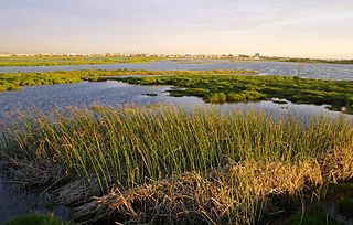
The Two Peoples Bay and Mount Manypeaks Important Bird Area is a 261 km2 tract of coastal and subcoastal land east of the city of Albany in south-west Western Australia. It is an important site for the conservation of several rare and threatened birds.

The Cheetham Wetlands are 420 hectares of artificial and natural lagoons, created on old salt works land on the western shores of Port Phillip Bay, Australia. The wetlands are approximately 20 kilometres (12 mi) southwest of Melbourne, and sit within the Municipal Councils of Hobsons Bay and Wyndham City.

The Central Gardens Nature Reserve, also called Central Gardens, is a protected nature reserve located in the western suburbs of Sydney, New South Wales, Australia. Established in 1976, the 12-hectare (30-acre) reserve, garden and fauna and wildlife park is situated in the suburb of Merrylands and is managed by Cumberland Council. The park is regionally important and it attracts visitors outside the Cumberland local government area. The bushland contains remnants of Cumberland Plain Woodland and is approximately 3.5 hectares.
The Point Cook Coastal Park covers an area of 863 hectares and includes the Cheetham Wetlands. The park extends from the RAAF Williams Point Cook Base northeast along the coast to the Laverton creek which comprises its northern boundary. The park is approximately 20 kilometres (12 mi) from Melbourne, Australia in a southwesterly direction along Port Phillip Bay. The park is adjoined by the Point Cook Marine Sanctuary, which extends around the point to the south and the east. The northwestern boundary to the park is residential housing.

