Anlaby Common

Last updated

Anlaby Avenue, Anlaby Common Anlaby Avenue Anlaby Common.jpg
Anlaby Avenue, Anlaby Common

Anlaby Common is former common land, now an outer suburb of Kingston upon Hull. The area includes the residential areas which are located on the western urban fringe of Hull; the B1231 road (Hull Road/Springfield Way) passes through all of Anlaby Common's estates, east to west.

Contents

As of 2011 the western part of the land is located in the civil parish of Anlaby with Anlaby Common in the East Riding of Yorkshire; whilst the eastern part of the land is located in Kingston upon Hull.

Geography

Historically Anlaby Common was an area of agricultural land east of Anlaby; the historic 'Anlaby Common' area now includes several areas of housing, including areas known as East Ella, Anlaby Park, and Anlaby Common; [1] the historic Anlaby Common area includes land within both the East Riding of Yorkshire and the city of Hull. [2] [1]

The present urban development in the area is essentially contiguous with than of Hull, as of 2006 there is a some green space including playing fields separating the area and Anlaby village, though housing development along Anlaby Road is almost continuous. [2]

The area includes the churches of Anlaby Park Methodist Church and St Mark's Anglican parish church; these churches work closely together under the name "Common Ground". Anlaby Common is near the small suburb of East Ella.

History

In the 1850s Anlaby Common was enclosed land in open countryside to the east of the village of Anlaby. [map 1] The area included a number of farms, and two large houses, Spring Villa (built 1840 [3] ), and East Ella (built 1842 [3] [map 2] ). The Hull and Kirk Ella Trust road (later Anlaby Road) ran east west through the area; a northern border approximated to Derringham Dike/Spring Bank waterway and road, whilst to the south was Hessle common across fields. [4]

By the 1890s the Hull, Barnsley and West Riding Junction Railway (HB&WRJnc.Rlwy.) had been constructed, east–west, across the land (c.1880s), and construction of terraced and court housing had taken place north-west of Spring Villa (Ditmas Avenue etc.), on the north side of Anlaby Road. The HB&WRJnc.Rlwy built a locomotive works (Springhead locomotive works), [map 3] and sidings in the north-eastern part of the common. [5]

By 1910 the locomotive works and sidings had been considerably expanded, and by the mid 1920s the housing estate of Anlaby Park had been built (begun 1911 as a private development on the grounds of Spring Villa, [6] [map 4] as well as the Almhouses Lee's Rest Houses; [map 5] [7] to the east, the former East Ella house had been redeveloped as part of the White City Pleasure Grounds, with additional buildings including dance and concert halls. [7] [8] To the north of Lee's Rest Homes a second almshouse, Trinity House Almshouses, was built 1938–40. [6] [map 6]

A large fire destroyed the White City stadium in 1938. Remaining parts of the pleasure ground were demolished in 1945, and East Ella house in around 1951. [8] Temporary housing was constructed on the grounds in the post Second World War period (Arcon Drive, demolished and redeveloped 1977). [9] [10] [11]

Eastfield school, est. 1930, expanded 1936 (2008) Eastfield Primary School - geograph.org.uk - 702231.jpg
Eastfield school, est. 1930, expanded 1936 (2008)

In the mid 20th century housing development became more extensive, and became contiguous with the westward urban spread of Hull, as well as with the suburb of Gipsyville to the south-east, with building south of Anlaby Road in the East Ella area; on the north side of the road, north of Anlaby Park; as well as towards Anlaby village west of Anlaby Park. [12] Eastfield School was established in East Ella south of Anlaby Road in 1930 as a 400 place junior and infants school, [map 7] and expanded 1936 with 400 senior places; in 1945 it became Eastfield High School. [13]

A cinema was built on the corner of Calvert Lane and Spring Bank West in 1938, the Priory. [14] [map 8] The cinema closed 1951, and was later used as shops. It is now a Heron Foods small supermarket. [14] [15]

Further housing development took place on the western part of the area in the second half of the 20th century, with housing development extending south across Hessle common by the 1960s, with Sydney Smith High School built in fields westwards, and south of Anlaby. [16] A high rise at Lindsey Place on the East Ella hall site was completed 1964. [11] [map 9] By the 1970s housing had further expanded and northwards over part of the site of the defunct railway sidings, with further development on former railway land in the 1980s and 1990s. The urban spread of Hull became essentially continuous to Anlaby by the 1970s north of Anlaby Road. [17]

Related Research Articles

<span class="mw-page-title-main">Haltemprice</span> Area of the East Riding of Yorkshire, England

Haltemprice is an area in the East Riding of Yorkshire, England, directly to the west of Hull. Originally an extra-parochial area, it became a civil parish in 1858, in 1935 it was expanded by the combination of the urban districts of Cottingham, Anlaby, and Sculcoates to form a new urban district; the district included the villages of Anlaby, Cottingham, Hessle, Kirk Ella, Skidby, West Ella and Willerby. Urban districts were abolished 1974.

Hullshire was a county corporate in the East Riding of Yorkshire, England from 1440 to 1889. Hullshire may refer to the area outside the town of Kingston upon Hull, whilst the entire entity was sometimes referred to as the "Town and County of Kingston upon Hull".

<span class="mw-page-title-main">Cottingham, East Riding of Yorkshire</span> Village and civil parish in the East Riding of Yorkshire, England

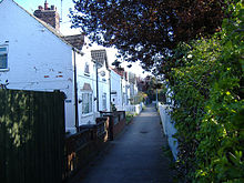
Cottingham is a large village and civil parish in the East Riding of Yorkshire, England. It lies 4 miles (6 km) north-west of the centre of Kingston upon Hull, and 6 miles (10 km) south-east of Beverley on the eastern edge of the Yorkshire Wolds. It forms part of Hull's Urban Area. It has two main shopping streets, Hallgate and King Street, which cross each other near the Church of Saint Mary the Virgin, and a market square called Market Green. Cottingham had a population of 17,164 residents in 2011, making it larger by area and population than many towns. As a result, it is one of the villages claiming to be the largest village in England.

<span class="mw-page-title-main">Hull Paragon Interchange</span> Transport interchange in Kingston upon Hull, East Riding of Yorkshire, England

Hull Paragon Interchange is a transport interchange providing rail, bus and coach services located in the city centre of Kingston upon Hull, England. The G. T. Andrews-designed station was originally named Paragon Station, and together with the adjoining Station Hotel, it opened in 1847 as the new Hull terminus for the growing traffic of the York and North Midland (Y&NMR) leased to the Hull and Selby Railway (H&S). As well as trains to the west, the station was the terminus of the Y&NMR and H&S railway's Hull to Scarborough Line. From the 1860s the station also became the terminus of the Hull and Holderness and Hull and Hornsea railways.

<span class="mw-page-title-main">Anlaby with Anlaby Common</span> Civil parish in the East Riding of Yorkshire, England

Anlaby with Anlaby Common is a civil parish in the East Riding of Yorkshire, England. The parish includes the village suburb of Anlaby and the part of the area known as Anlaby Common.

<span class="mw-page-title-main">Willerby, East Riding of Yorkshire</span> Village and civil parish in the East Riding of Yorkshire, England

Willerby is a village and civil parish located on the western outskirts of the city of Kingston upon Hull in the East Riding of Yorkshire, England.

<span class="mw-page-title-main">Kirk Ella</span> Village in the East Riding of Yorkshire, England

Kirk Ella is a village and civil parish on the western outskirts of Kingston upon Hull, approximately five miles west of the city centre, situated in the East Riding of Yorkshire, England. The parish includes West Ella.

<span class="mw-page-title-main">West Ella</span> Village in the East Riding of Yorkshire, England

West Ella is a small village in the civil parish of Kirk Ella west of Kirk Ella settlement, within the East Riding of Yorkshire, England, on the eastern edge of the Yorkshire Wolds, approximately 6 miles (10 km) west of the city of Kingston upon Hull.

<span class="mw-page-title-main">Anlaby</span> Village in the East Riding of Yorkshire, England

Anlaby is a village forming part of the western suburbs of Kingston upon Hull, in the East Riding of Yorkshire, England. It forms part of the civil parish of Anlaby with Anlaby Common.

<span class="mw-page-title-main">Melton, East Riding of Yorkshire</span> Village in the East Riding of Yorkshire, England

Melton is a village in the civil parish of Welton, East Riding of Yorkshire, England. It is situated about 8 miles (13 km) west of Kingston upon Hull city centre near to the Humber Estuary and about 0.6 miles (1 km) east of the village of Welton, with which it is nearly contiguous.

<span class="mw-page-title-main">Orchard Park Estate</span> Estate in Kingston upon Hull, East Riding of Yorkshire, England

Orchard Park Estate is an area or housing estate situated on the north-western side of Kingston upon Hull, England.

<span class="mw-page-title-main">Stoneferry</span>

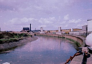
Stoneferry is a suburb of Kingston upon Hull, East Riding of Yorkshire, England. It was formerly a small hamlet on the east bank of the River Hull, the site of a ferry, and, after 1905, a bridge. The area is primarily industrial, and is situated on the east bank of the river, as well as close by areas on the west bank.

East Ella is a small suburb to the west of the Eastern England city of Kingston upon Hull. East Ella was an area of common land to the east of the nearby village of Anlaby and the west of Hull.

Gipsyville is a western suburb of Kingston upon Hull, in the East Riding of Yorkshire, England.

<span class="mw-page-title-main">Newland, Kingston upon Hull</span> Area of Kingston upon Hull, East Riding of Yorkshire, England

Newland is a suburb of Kingston upon Hull, East Riding of Yorkshire, England, in the north-west of the city, a former village on the Hull to Beverley turnpike.

<span class="mw-page-title-main">Southcoates</span> Area of Kingston upon Hull, East Riding of Yorkshire, England

Southcoates is an urban area in the eastern part of Kingston upon Hull, England.

<span class="mw-page-title-main">North Hull Estate</span> Area of Kingston upon Hull, East Riding of Yorkshire, England

The North Hull Estate is a residential area in the north of Kingston upon Hull, west of the River Hull, built by Hull Corporation in the interwar period.

<span class="mw-page-title-main">Dairycoates</span> Area of Kingston upon Hull in the East Riding of Yorkshire, England

Dairycoates is an area of Kingston upon Hull, East Riding of Yorkshire, England, a former hamlet.

<span class="mw-page-title-main">Preston Road Estate</span> Area of Kingston upon Hull, East Riding of Yorkshire, England

Preston Road Estate, also known as the East Hull Estate, is a housing estate in the east of Kingston upon Hull built from the 1920s to the 1940s by Hull Corporation. At the beginning of the 21st century considerable redevelopment of the estate took place, with a large community centre established, and demolition or modification of older substandard houses.

<span class="mw-page-title-main">Kingswood, Kingston upon Hull</span> Area in Kingston upon Hull, East Riding of Yorkshire, England

Kingswood, occasionally referred to as Kingswood Parks, is a modern housing estate on the northern fringe of Kingston upon Hull, England.

References

  1. 1 2 Ordnance Survey 1:10560 1856
  2. 1 2 Ordnance Survey 1:25000 2006
  3. 1 2 Allison, K. J. (1981). 'Hull Gent Seeks Country Residence' 1750–1850. East Riding Local History Society. p. 11.
  4. Ordnance Survey Sheet 240 1853
  5. Ordnance Survey c.1890s
  6. 1 2 Neave & Neave 2010, p. 169.
  7. 1 2 Ordnance Survey Sheet 240NW 1906-8, 1926
  8. 1 2 "25. White City Pleasure Grounds". The Anlaby Road. Retrieved 13 December 2014.
  9. Ordnance Survey 1:2500 1951–2
  10. "Pre-fabricated housing around Arcon Drive and environs, East Ella, 1948". Britain from above. Retrieved 13 December 2014.
  11. 1 2 "A pre-war City of Leisure – just over the border!". White City (Hull) Road Running Club. Retrieved 13 December 2014.
  12. Ordnance Survey Sheet 240NW 1906-8, 1938, 1947–9
  13. Allison, K. J., ed. (1969). "Education – Schools in Existence before 1945". The City of Kingston upon Hull. A History of the County of York East Riding. Vol. 1. Victoria County Histories.
  14. 1 2 Allison, K. J., ed. (1969). "Social institutions". The City of Kingston upon Hull. A History of the County of York East Riding. Vol. 1. Victoria County Histories. pp. 418–432.
  15. Lea, Catherine (3 February 2010). "10 new jobs as Heron plans store in former Priory Cinema in Hull". Hull Daily Mail. Retrieved 7 February 2016.[ permanent dead link ]
  16. Ordnance Survey 1:10560/10000 1956, 1968–9
  17. Ordnance Survey 1:10560/10000 1968–9, 1971–80, 1983–9, 1994–5

Locations

  1. 53°44′50″N0°24′47″W / 53.747307°N 0.413042°W , Anlaby Common (approximate)
  2. 53°44′45″N0°23′41″W / 53.745737°N 0.394713°W , East Ella house (site of)
  3. 53°44′55″N0°24′15″W / 53.748691°N 0.404278°W , Springhead locomotive works (site of)
  4. 53°44′34″N0°24′23″W / 53.742823°N 0.406416°W , Anlaby Park
  5. 53°44′37″N0°24′06″W / 53.743497°N 0.401568°W , Lee's Almshouses
  6. 53°44′46″N0°24′02″W / 53.745984°N 0.400545°W , Trinity House Almshouses
  7. 53°44′37″N0°23′46″W / 53.743731°N 0.396087°W , Eastfield school
  8. 53°44′59″N0°23′44″W / 53.749741°N 0.395579°W , former Priory Cinema
  9. 53°44′45″N0°23′44″W / 53.745839°N 0.395580°W , Lindsey Place (highrise)

Sources

  • Neave, David; Neave, Susan (2010). Hull. Pevsner Architectural Guides.
  • Gazetteer — A–Z of Towns Villages and Hamlets. East Riding of Yorkshire Council. 2006. p. 3.