The Cagayan River, also known as the Río Grande de Cagayán, is the longest river and the largest river by discharge volume of water in the Philippines. It has a total length of approximately 505 kilometres (314 mi) and a drainage basin covering 27,753 square kilometres (10,715 sq mi). It is located in the Cagayan Valley region in northeastern part of Luzon Island and traverses the provinces of Nueva Vizcaya, Quirino, Isabela and Cagayan.
Benguet, officially the Province of Benguet, is a landlocked province of the Philippines located in the southern tip of the Cordillera Administrative Region in the island of Luzon. Its capital is La Trinidad.

Ifugao, officially the Province of Ifugao, is a landlocked province of the Philippines in the Cordillera Administrative Region in Luzon. Its capital is Lagawe and it borders Benguet to the west, Mountain Province to the north, Isabela to the east, and Nueva Vizcaya to the south. Alfonso Lista is the most populous in the province.
Apayao, officially the Province of Apayao, is a landlocked province in the Philippines in the Cordillera Administrative Region in Luzon. Kabugao serves as its capital. The provincial capitol and its associated offices are located at the New Government Center in Luna. Conner is the most populous town in the province.

Kalinga, officially the Province of Kalinga, is a landlocked province in the Philippines situated within the Cordillera Administrative Region in Luzon. Its capital is Tabuk and borders Mountain Province to the south, Abra to the west, Isabela to the east, Cagayan to the northeast, and Apayao to the north. Kalinga and Apayao are the result of the 1995 partitioning of the former province of Kalinga-Apayao which was seen to better service the respective needs of the various indigenous peoples in the area.

Kalinga-Apayao was a province of the Philippines in the Cordillera Administrative Region in the island of Luzon. It was formed, along with Benguet, Ifugao, and the new Mountain Province, from the earlier Mountain Province, with the passage of Republic Act No. 4695 in 1966. The said law was amended by RA No. 7878 in 1995, which divided the province into two new ones, Kalinga and Apayao.

The Cordillera Administrative Region, also known as the Cordillera Region and Cordillera, is an administrative region in the Philippines, situated within the island of Luzon. It is the only landlocked region in the insular country, bordered by the Ilocos Region to the west and southwest, and by the Cagayan Valley Region to the north, east, and southeast. It is the least populous region in the Philippines, with a population less than that of the city of Manila.

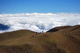
The Cordillera Central or Cordillera Range is a massive mountain range 320 kilometres (200 mi) long north–south and 118 kilometres (73 mi) east-west situated in the north-central part of the island of Luzon, in the Philippines. The mountain range encompasses all provinces of the Cordillera Administrative Region, as well as portions of eastern Ilocos Norte, eastern Ilocos Sur, eastern La Union, northeastern Pangasinan, western Nueva Vizcaya, and western Cagayan.
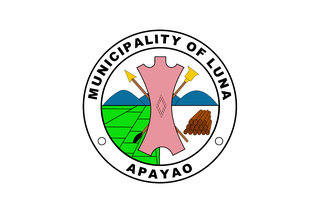
Luna, officially the Municipality of Luna, is a 2nd class municipality in the province of Apayao, Philippines. According to the 2020 census, it has a population of 21,297 people. It currently serves as the de facto capital of Apayao where the provincial capitol and related offices is located the New Apayao Government Center. Kabugao remains as the de jure capital.

The indigenous peoples of the Cordillera in northern Luzon, Philippines, often referred to by the exonym Igorot people, or more recently, as the Cordilleran peoples, are an ethnic group composed of nine main ethnolinguistic groups whose domains are in the Cordillera Mountain Range, altogether numbering about 1.8 million people in the early 21st century.

Pudtol, officially the Municipality of Pudtol,, is a 4th class municipality in the province of Apayao, Philippines. According to the 2020 census, it has a population of 15,491 people.
Santa Marcela, officially the Municipality of Santa Marcela, is a 4th class municipality in the province of Apayao, Philippines. According to the 2020 census, it has a population of 13,317 people.

Abulug, officially the Municipality of Abulug, is a 3rd class municipality in the province of Cagayan, Philippines. According to the 2020 census, it has a population of 34,579 people.

Sadanga, officially the Municipality of Sadanga is a 5th class municipality in the province of Mountain Province, Philippines. According to the 2020 census, it has a population of 8,427 people.

Calanasan, officially the Municipality of Calanasan, (Isnag: Ili naya Calanasan; Ilocano: Ili ti Calanasan; Tagalog: Bayan ng Calanasan), is a 1st class municipality in the province of Apayao, Philippines. According to the 2020 census, it has a population of 12,550 people, making it the least populated municipality in the province.
Conner, officially the Municipality of Conner,, is a 2nd class municipality in the province of Apayao, Philippines. According to the 2020 census, it has a population of 27,552 people making it the most populous town in the province.

Flora, officially the Municipality of Flora, is a 3rd class municipality in the province of Apayao, Philippines. According to the 2020 census, it has a population of 17,944 people.
Kabugao, officially the Municipality of Kabugao, is a 1st class municipality and de jure capital of the province of Apayao, Philippines. According to the 2020 census, it has a population of 16,215 people.

Pinukpuk, officially the Municipality of Pinukpuk is a 1st class municipality in the province of Kalinga, Philippines. According to the 2020 census, it has a population of 34,275 people.
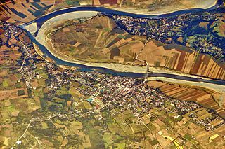
The Abulog River or Abulug River is the 9th largest river system in the Philippines in terms of watershed size. It has an estimated drainage area of 3,372 square kilometres (1,302 sq mi) and a length of 196 kilometres (122 mi) from its source in the mountains of Apayao in the Cordillera Administrative Region. More than 90% of the drainage area of the river is located in Apayao province while the remaining, including the mouth of the river, is in Cagayan province.

