A caldera is a large cauldron-like hollow that forms shortly after the emptying of a magma chamber in a volcanic eruption. An eruption that ejects large volumes of magma over a short period of time can cause significant detriment to the structural integrity of such a chamber, greatly diminishing its capacity to support its own roof, and any substrate or rock resting above. The ground surface then collapses into the emptied or partially emptied magma chamber, leaving a large depression at the surface. Although sometimes described as a crater, the feature is actually a type of sinkhole, as it is formed through subsidence and collapse rather than an explosion or impact. Compared to the thousands of volcanic eruptions that occur over the course of a century, the formation of a caldera is a rare event, occurring only a few times within a given window of 100 years. Only eight caldera-forming collapses are known to have occurred between 1911 and 2018, with a caldera collapse at Kīlauea, Hawaii in 2018. Volcanoes that have formed a caldera are sometimes described as "caldera volcanoes".

Mount Katmai is a large active stratovolcano on the Alaska Peninsula in southern Alaska, located within Katmai National Park and Preserve. It is about 6.3 miles (10 km) in diameter with a central lake-filled caldera about two by three miles in size, formed during the Novarupta eruption of 1912. The caldera rim reaches a maximum elevation of 6,716 feet (2,047 m). In 1975 the surface of the crater lake was at an elevation of about 4,220 feet (1,286 m), and the estimated elevation of the caldera floor is about 3,400 ft (1,040 m). The mountain is located in Kodiak Island Borough, very close to its border with Lake and Peninsula Borough. The volcano has caused ten known fatalities due to gas exposure.

Mount Spurr (Dena'ina: K'idazq'eni) is a stratovolcano in the Aleutian Arc of Alaska, named after United States Geological Survey geologist and explorer Josiah Edward Spurr, who led an expedition to the area in 1898. The Alaska Volcano Observatory (AVO) currently rates Mount Spurr as Level of Concern Color Code Green. The mountain is known aboriginally by the Dena'ina Athabascan name K'idazq'eni, literally 'that which is burning inside'.

Masaya is a caldera located in Masaya, Nicaragua, 20 km (12 mi) south of the capital Managua. It is Nicaragua's first and largest national park, and one of 78 protected areas of Nicaragua. The complex volcano is composed of a nested set of calderas and craters, the largest of which is Las Sierras shield volcano and caldera. Within this caldera lies a sub-vent, which is Masaya Volcano sensu stricto. The vent is a shield type composing of basaltic lavas and tephras and includes a summit crater. This hosts Masaya caldera, formed 2,500 years ago by an 8 km3 (1.9 cu mi) basaltic ignimbrite eruption. Inside this caldera a new basaltic complex has grown from eruptions mainly on a semi-circular set of vents that include the Masaya and Nindiri cones. The latter host the pit craters of Masaya, Santiago, Nindiri and San Pedro. Observations in the walls of the pit craters indicate that there have been several episodes of cone and pit crater formation.

An active volcano is a volcano that has erupted during the Holocene, is currently erupting, or has the potential to erupt in the future. A volcano that is not currently erupting but could erupt in the future is known as a dormant volcano. Volcanoes that will not erupt again are known as extinct volcanoes.
The Decade Volcanoes are 16 volcanoes identified by the International Association of Volcanology and Chemistry of the Earth's Interior (IAVCEI) as being worthy of particular study in light of their history of large, destructive eruptions and proximity to densely populated areas. The Decade Volcanoes project encourages studies and public-awareness activities at these volcanoes, with the aim of achieving a better understanding of the volcanoes and the dangers they present, and thus being able to reduce the severity of natural disasters.
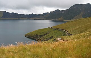
Mojanda is an inactive stratovolcano of the Eastern Cordillera of the Andes in northern Ecuador. A summit caldera, which was produced by an explosive Plinian Eruption that marked the end of Mojanda activity 200,000 years ago, is occupied by three crater lakes: Karikucha, Yanakucha, and Warmikucha. Having received protected status in 2002, they are a popular tourist destination and are about 20 minutes taxi ride from the largely indigenous town of Otavalo.

Billy Mitchell is a pyroclastic shield in the central part of the island of Bougainville, just north-east of the Bagana Volcano in Papua New Guinea. It is a small pyroclastic shield truncated by a 2 km wide caldera filled by a crater lake. It is named after Billy Mitchell, a 20th-century United States Army general who is regarded as the father of the United States Air Force.

Cosigüina is a stratovolcano located in the western part of Nicaragua. It forms a large peninsula extending into the Gulf of Fonseca. The summit is truncated by a large caldera, 2 x 2.4 km in diameter and 500 m deep, holding a substantial crater lake. This cone has grown within an earlier caldera, forming a somma volcano. The earlier caldera rim is still exposed on the north side, but has been buried by the younger cone elsewhere.

Lake Ilopango is a crater lake which fills an 8 by 11 km volcanic caldera in central El Salvador, on the borders of the San Salvador, La Paz, and Cuscatlán departments. The caldera, which contains the second largest lake in the country and is immediately east of the capital city, San Salvador, has a scalloped 100 m (330 ft) to 500 m (1,600 ft) high rim. Any surplus drains via the Jiboa River to the Pacific Ocean. The local military airbase, Ilopango International Airport, has annual airshows where international pilots from all over the world fly over San Salvador City and Ilopango lake.

In volcanology, a pyroclastic shield or ignimbrite shield is an uncommon type of shield volcano. Unlike most shield volcanoes, pyroclastic shields are formed mostly of pyroclastic and highly explosive eruptions rather than relatively fluid basaltic lava issuing from vents or fissures on the surface of the volcano. They typically display low-angle flank slopes and often have a central caldera caused by large eruptions. Lava is commonly extruded after explosive activity has ended. The paucity of associated Plinian fall deposits indicates that pyroclastic shields are characterized by low Plinian columns.
Chiltepe Peninsula Natural Reserve is a nature reserve in Nicaragua. It is one of the 78 reserves which are officially under protection in the country.

The Silverthrone Caldera is a potentially active caldera complex in southwestern British Columbia, Canada, located over 350 kilometres (220 mi) northwest of the city of Vancouver and about 50 kilometres (31 mi) west of Mount Waddington in the Pacific Ranges of the Coast Mountains. The caldera is one of the largest of the few calderas in western Canada, measuring about 30 kilometres (19 mi) long (north-south) and 20 kilometres (12 mi) wide (east-west). Mount Silverthrone, an eroded lava dome on the caldera's northern flank that is 2,864 metres (9,396 ft) high, may be the highest volcano in Canada.

Chaitén is a volcanic caldera 3 kilometres (2 mi) in diameter, 17 kilometres (11 mi) west of the elongated ice-capped Michinmahuida volcano and 10 kilometres (6 mi) northeast of the town of Chaitén, near the Gulf of Corcovado in southern Chile. The most recent eruptive phase of the volcano erupted on 2008. Originally, radiocarbon dating of older tephra from the volcano suggested that its last previous eruption was in 7420 BC ± 75 years. However, recent studies have found that the volcano is more active than thought. According to the Global Volcanism Program, its last eruption was in 2011.

Akan Volcanic Complex is a volcanic group of volcanoes that grew out of the Akan caldera. It is located within Akan National Park, about 50 km Northwest of Kushiro in eastern Hokkaidō, Japan.

Laguna Caldera is a potentially active volcanic caldera and a geographical depression in Rizal, Philippines. It is broadly elliptical in shape, with dimensions of 20 by 10 km. It has a summit elevation of 743 metres (2,438 ft). The caldera forms the middle lobe of Laguna de Bay, bound by the Morong Peninsula and Talim Island to the west, and the Jalajala Peninsula to the east.

The volcanic history of the Northern Cordilleran Volcanic Province presents a record of volcanic activity in northwestern British Columbia, central Yukon and the U.S. state of easternmost Alaska. The volcanic activity lies in the northern part of the Western Cordillera of the Pacific Northwest region of North America. Extensional cracking of the North American Plate in this part of North America has existed for millions of years. Continuation of this continental rifting has fed scores of volcanoes throughout the Northern Cordilleran Volcanic Province over at least the past 20 million years and occasionally continued into geologically recent times.

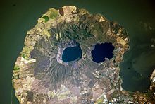
Mount Hakone, with its highest peak Mount Kami, is a complex volcano in Kanagawa Prefecture, Japan that is truncated by two overlapping calderas, the largest of which is 10 × 11 km wide. The calderas were formed as a result of two major explosive eruptions about 180,000 and 49,000–60,000 years ago. Lake Ashi lies between the southwestern caldera wall and a half dozen post-caldera lava domes that arose along a southwest–northeastern trend cutting through the center of the calderas. Dome growth occurred progressively to the south, and the largest and youngest of them, Mount Kami, forms the high point of Hakone. The calderas are breached to the east by the Haya River canyon. Mount Ashigara is a parasitic cone.