Apple Fire

Last updated

Apple Fire
The Apple Fire burns north of Beaumont, Friday, July 31, 2020.jpg
The Apple Fire burns north of Beaumont on the evening of Friday, July 31, 2020.
Date(s)
  • July 31, 2020 (2020-07-31)
  • November 18, 2020 (2020-11-18) [1]
Location Cherry Valley, Riverside County, California, US
Coordinates 33°59′25″N116°57′49″W / 33.990352°N 116.963678°W / 33.990352; -116.963678
Statistics [2]
Burned area33,424 acres (13,526 ha)
Impacts
Non-fatal injuries1
Structures destroyed12 structures, 2 outbuildings destroyed
Ignition
CauseBurning carbon emitted from the tailpipe of vehicle
Map
2020 Apple Fire map.png
The footprint of the Apple Fire
USA California Southern location map.svg
FireIcon.svg
Location in Southern California

The Apple Fire was a wildfire that burned during the 2020 California wildfire season in Cherry Valley south of Oak Glen and north of Beaumont and Banning in Riverside County, California in the United States. The fire ignited on Friday, July 31, 2020 as three separate smaller blazes within the rural canyons along Oak Glen Road before merging and rapidly expanded to 1,900 acres (769 ha) and destroyed at least one home and two outbuildings in the Cherry Valley area. [3] It now covers at least 33,424 acres (13,526 ha) and created "a plume of smoke so massive that it generated its own winds." [4] [5] The fire was sparked by a diesel-burning vehicle that emitted burning carbon. [6] The fire was named after one of the roadways close to the ignition site, which is named Apple Tree Lane. [7]

Contents

Progression

Reportedly starting at 4:55 pm PST on Friday, July 31, as what was initially presumed to be two potential arson ignitions that later merged into one another, the fires started along the 9000 block of Oak Glen Road and Apple Tree Lane in the unincorporated community of Cherry Valley bordering Beaumont. [3] [8] The two separate fires merged just under an hour later at 5:45 pm. A third initially presumed arson fire had also been reported due south of the first two, which went on to burn between 60 and 80 acres as well as several unidentified buildings. [3]

The main fire proceeded to rapidly expand to 350 acres within its first two hours prompting the Riverside County Sheriff's Department to issue mandatory evacuations for well over 200 residences in the Cherry Valley area. [9] No containment was reported throughout the day while the fire grew considerably as it burned predominantly in a north, east and southward direction towards the Banning bluff area. The wind, high temperatures and inaccessible topography of the area allowed for the fire to burn aggressively as firefighting agencies from Riverside County its surrounding counties were requested to aid in containing the fire. By 9 pm, evacuations were extended to residents living north of Gilman Street in the Banning bluff area as the fire was by this time reportedly now 1,900 acres (769 ha) in size and remained zero percent contained.

In the early morning hours of Saturday, August 1, after a brief lull in fire activity due to low overnight temperatures, the Apple Fire began to further display aggressive and rapid activity due to the rising temperatures, low humidity and strong winds as well as rugged inaccessible terrain that the fire proceeded to advance towards. This caused the fire to explode into the Banning Bluff area which spurred additional mandatory evacuations as it rapidly burned further into the San Bernardino National Forest and up along the south facing side of the San Gorgonio Mountain Range. [10] By 12 pm, the fire had been reportedly sized up at 4,100 acres with still zero percent containment. [7] Additionally, up to 7,800 people had been ordered to evacuate. Within less than 24 hours, the fire had rapidly expanded by 13,000 acres to encompass upwards of 15,000 acres (6,070 ha) by near midnight as the fireline still remained zero percent contained. [11] [12] By Sunday night, on August 2, it surpassed 20,500 acres (8,296 ha) while firefighters finally reached 5% containment. [13] The San Gorgonio Wilderness was also closed off by an Emergency Forest Closure Order, prohibiting entrance to any part of the wilderness.

Smoke from the Apple Fire blows over a significant portion of Arizona on August 2, 2020. Smoke from the Apple Fire over Arizona on August 2, 2020.jpg
Smoke from the Apple Fire blows over a significant portion of Arizona on August 2, 2020.

By Monday, August 3, the fire had grown to be 26,450 acres (10,704 ha). Containment did not increase. New evacuation orders were issued for residents living in the area north of Morongo Rd, east of Miller Canyon Road, and west of Whitewater Canyon Rd. Orders were also given to people living in the Potato Canyon west, to Raymond Flat in the Oak Glen area. [14] The fire mostly burned north and east towards the San Gorgonio Wilderness. Many of those areas had no recent fire history, and this was further assisted by vegetation with record low moisture contents. Weather-wise, high temperatures, very strong gusts, and low relative humidity all contributed to hampering firefighting efforts. [15] Late into the night, the fire grew to be 26,850 acres (10,866 ha). Firefighters were also able to get up to 7% containment.

By Tuesday, August 4, the fire had not grown any further. Containment was up to 15%. Officials attribute this slowdown due to the Apple Fire burning in areas with sparse vegetation. An evacuation order was issued for the San Bernardino community of Oak Glen, while Forest Falls, Pioneer Town, and Rim Rock given evacuation warnings. 11 more structures were also destroyed, bringing the damage to 12 structures and 2 outbuildings by Tuesday. Weather -wise, officials predicted that the conditions would be warm and dry for most of the day, before cooling down a little and relative humidity increasing in the afternoon. Humidity was expected to drop later that night. [16] Later that night, containment was increased to 20%, with still no fire spread.

By Wednesday, August 5, the fire had grown to 27,319 acres (11,056 ha). Containment also increased to 30%. Authorities lifted all evacuation orders for Riverside County, but not for San Bernardino County. Road closures for Riverside County were also lifted, but were not lifted for San Bernardino County. The Beaumont High School was also closed, as there was no more need for an evacuation center in Riverside County. Weather-wise, a morning marine layer kept temperatures cooler for firefighters, but afternoon winds were predicted to pick up speed. [17] Later that night, the fire grew to 27,569 acres (11,157 ha). Containment stayed at 30%.

By Thursday, August 6, the fire had grown to 28,085 acres (11,366 ha). Containment was still at 30%. The fire was still moving towards the San Gorgonio Wilderness, and burning through vegetation with no recent fire history. However, going deeper, the fire was predicted to burn into areas with dead vegetation, and also timber that had been killed by bark beetles. Weather-wise, the conditions were expected to be favorable for firefighters. This included a continuation of the cooling trend that had begun yesterday. However, winds were expected to pick up speed in the afternoon. Regarding evacuations, most everything stayed the same, except for new evacuation warnings for the area east of Potrero Rd, north of Morongo Rd, and west of Whitewater Canyon Rd. [18]

Effects

The first day of the fire, Friday, July 31 saw significant mandatory evacuations for numerous communities surrounding the initial fire area as the blaze rapidly grew. During the fire's first two hours of burning the areas of At 7 pm, Friday, July 31, mandatory evacuations were ordered for residents in Cherry Valley north of Dutton Street, east of Oak Glen Road and south of County Line Road. By 9 pm, evacuations were extended to residents living north of Gilman Street in the Banning bluff area. And by 11 pm, evacuation orders were again extended north of Cherry Valley Boulevard, west of Highland Springs Avenue and east of Beaumont Avenue. An evacuation center was set up at Beaumont High School at 39139 Cherry Valley Boulevard in Beaumont. [19] Additional mandatory evacuations were ordered for residences living along the Banning Bench and road closures were put in place along North Sunset Avenue at Wilson Street and North San Gorgonio Avenue at Summit Drive as the fire advanced towards the community. [20] Smoke also made its way from the fire to areas as far as Arizona and San Diego. An evacuation order was also given for Oak Glen in San Bernardino County, while Forest Falls, Pioneer Town, and Rim Rock were issued evacuation warnings. However, all road closures and evacuations for Riverside County were lifted on August 5. However, the communities in San Bernardino County did not have their evacuation warnings and orders lifted. [21]

Cause

On Monday, August 3, several days after the three spot fires that later merged into the Apple Fire had broken out, arson investigators had determined that the cause of the fires was the result of "hot objects" emanating from a vehicle tailpipe. [22] CALFIRE officials stated that a diesel-fueled vehicle had emitted burning carbon from the exhaust system and into nearby brush and chaparral, according to multiple independent eyewitnesses as well as supporting physical evidence. [22] [23] In the early hours of the fire, a rumor had begun circulating that the fires were deliberately set along Oak Glen Road and Apple Tree Lane, which some conflicting reports of a person fleeing the area at the time of the ignitions. [23] However, CAL FIRE investigators were certain due to the supporting evidence that it was in fact a vehicle malfunction shooting out black soot that started the three fires. [23]

See also

Related Research Articles

<span class="mw-page-title-main">2013 Colorado wildfires</span>

In the summer of 2013, there were several major wildfires in Colorado in the United States. During June and July, record high temperatures and dry conditions fueled the fires all across the state. By July 24, 570 structures had been destroyed and 2 people died. Below is a list of the major fires of the year.

The Uno Peak Fire was a wildfire on the slopes of Lake Chelan, approximately 15 miles from Manson, Washington in the United States. The human caused fire was started on August 30, 2017. The fire burned a total of 8,726 acres (35 km2).

<span class="mw-page-title-main">Valley Fire (2018)</span> 2018 wildfire in Southern California

The Valley Fire was a wildfire that burned near the community of Forest Falls in San Bernardino National Forest, including the San Gorgonio Wilderness in California, United States. The fire was reported on July 6, one of a handful of brush fires that started in the area due to high temperatures and dry conditions. The Valley Fire burned 1,350 acres (5 km2) before it was fully contained on October 22. The fire impacted traffic on Highway 38 due to road closures and has caused evacuations of Forest Falls.

<span class="mw-page-title-main">Ferguson Fire</span> 2018 wildfire in Central California

The Ferguson Fire was a major wildfire in the Sierra National Forest, Stanislaus National Forest and Yosemite National Park in California in the United States. The fire was reported on July 13, 2018, burning 96,901 acres (392 km2), before it was 100% contained on August 19, 2018. Interior areas of the fire continued to smolder and burn until September 19, 2018, when InciWeb declared the fire to be inactive. The Ferguson Fire was caused by the superheated fragments of a faulty vehicle catalytic converter igniting vegetation. The fire, which burned mostly in inaccessible wildland areas of the national forest, impacted recreational activities in the area, including in Yosemite National Park, where Yosemite Valley and Wawona were closed. The Ferguson Fire caused at least $171.2 million in damages, with a suppression cost of $118.5 million and economic losses measuring $52.7 million. Two firefighters were killed and nineteen others were injured in the fire.

<span class="mw-page-title-main">Cranston Fire</span> 2018 wildfire in Southern California

The Cranston Fire was a wildfire that burned in southwest Riverside County, California, in the United States. The fire was started on July 25, 2018, by Brandon M. McGlover, in an act of arson. The fire burned a total of 13,139 acres (53 km2), before it was fully contained on August 10. The Cranston Fire impacted the communities of Idyllwild and Mountain Center, as well as recreational activities in the Lake Hemet area, San Bernardino National Forest and Mount San Jacinto State Park. Over 7,000 people were evacuated due to the Cranston Fire.

<span class="mw-page-title-main">Mendocino Complex Fire</span> 2018 wildfire in Northern California

The Mendocino Complex Fire was a large complex of wildfires that burned in northern California for more than three months in 2018. It consisted of two wildfires, the River Fire and Ranch Fire, which burned in Mendocino, Lake, Colusa, and Glenn Counties in the U.S. State of California, with the Ranch Fire being California's single-largest recorded wildfire at the time until the Dixie Fire in 2021. The Ranch Fire burned eight miles northeast of Ukiah, and the River Fire burned six miles north of Hopland, to the south of the larger Ranch Fire. First reported on July 27, 2018, both fires burned a combined total of 459,123 acres (1,858 km2), before they were collectively 100% contained on September 18, though hotspots persisted until the complex was fully brought under control on January 4, 2019. The Ranch Fire alone burned 410,203 acres (1,660 km2), making it the largest wildfire in modern California history at the time until the August Complex fire that occurred in 2020. The Ranch Fire also surpassed the size of the 315,577-acre Rush Fire, which burned across California and Nevada, as well as the Santiago Canyon Fire of 1889, which was previously believed to have been California's all-time largest wildfire. It also included the Redwood Valley Fire that claimed 8 lives.

<span class="mw-page-title-main">2019 California wildfires</span> An overview of major wildfires in California during the year 2019

The 2019 California wildfire season was a series of wildfires that burned across the U.S. state of California as part of the 2019 wildfire season. By the end of the year, according to Cal Fire and the US Forest Service, 7,860 fires were recorded, totaling an estimated of 259,823 acres of burned land. These fires caused 22 injuries, 3 fatalities, and damaged or destroyed 732 structures. The 2019 California fire season was less active than that of the two previous years, which set records for acreage, destructiveness, and deaths.

<span class="mw-page-title-main">2020 California wildfires</span> An overview of major wildfires in California during the year 2020

The 2020 California wildfire season, part of the 2020 Western United States wildfire season, was a record-setting year of wildfires in California. By the end of the year, 9,917 fires had burned 4,397,809 acres (1,779,730 ha), more than 4% of the state's roughly 100 million acres of land, making 2020 the largest wildfire season recorded in California's modern history, though roughly equivalent to the pre-1800 levels which averaged around 4.4 million acres yearly and up to 12 million in peak years. California's August Complex fire has been described as the first "gigafire", burning over 1 million acres across seven counties, an area larger than the state of Rhode Island. The fires destroyed over 10,000 structures and cost over $12.079 billion in damages, including over $10 billion in property damage and $2.079 billion in fire suppression costs. The intensity of the fire season has been attributed to a combination of more than a century of poor forest management and higher temperatures resulting from climate change.

<span class="mw-page-title-main">Bush Fire (Arizona)</span> 2020 Arizona wildfire

The Bush Fire was a human-caused wildfire that started in the Tonto National Forest northeast of Phoenix, Arizona. It burned 193,455 acres (78,288 ha). The fire started on June 13, 2020 near the intersection of Bush Highway and SR 87 and was fully contained on July 6, 2020

<span class="mw-page-title-main">2020 Utah wildfires</span> Wildfire season

The 2020 Utah wildfire season was a series of prominent wildfires throughout the state of Utah, lasting from June 1 through October 30, as defined by state law. Part of the 2020 Western United States wildfire season, Utah saw record-breaking numbers of human-caused fires. The largest fire of the season, the East Fork Fire, burned an area of 89,568 acres. In total, the suppression costs for the fires amounted to at least $103 million.

<span class="mw-page-title-main">Mineral Fire (2020)</span> 2020 wildfire in Central California

The Mineral Fire was a wildfire that burned in Coalinga Mineral Springs, west of Coalinga in Fresno, California in the United States. The fire was first reported on July 13, 2020 and burned an estimated 29,667 acres (12,006 ha) and before being fully contained on July 26. The fire threatened the communities of Los Gatos Creek Road from Indian Springs to Union Carbide Road and Bingham Springs. It resulted in the mandatory evacuations of Los Gatos Creek Road and Bingham Springs and led to the complete closure of State Route 198 from Firestone Ave. to the Monterey County Line. They were subsequently lifted on July 20.

<span class="mw-page-title-main">Lake Fire (2020)</span> 2020 wildfire in Southern California

The Lake Fire was a wildfire that burned during the 2020 California wildfire season in the Angeles National Forest in Los Angeles County in the state of California in the United States. The fire, which was first reported on August 12, 2020, burned 31,089 acres (12,581 ha) near Lake Hughes. It was fully contained on September 28. The cause of the fire remains unknown. The fire has damaged 3 structures, destroyed 12 structures and 21 outbuildings, and injured 4 firefighters.

<span class="mw-page-title-main">Loyalton Fire</span> 2020 wildfire in California and Nevada

The 2020 Loyalton Fire was a large wildfire in Lassen, Plumas and Sierra counties in California and Washoe County in Nevada. After it was ignited by lightning on August 14, 2020, the fire burned 47,029 acres (19,032 ha) in the Tahoe National Forest and the Humboldt-Toiyabe National Forest before it was fully contained on August 26. The Loyalton Fire was notable for generating three fire tornadoes on August 15, necessitating first-of-their-kind warnings by the National Weather Service.

<span class="mw-page-title-main">North Complex Fire</span> 2020 wildfire in Northern California

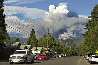
The North Complex Fire was a massive wildfire complex that burned in the Plumas National Forest in Northern California in the counties of Plumas and Butte. 21 fires were started by lightning on August 17, 2020; by September 5, all the individual fires had been put out with the exception of the Claremont and Bear Fires, which merged on that date, and the Sheep Fire, which was then designated a separate incident. On September 8, strong winds caused the Bear/Claremont Fire to explode in size, rapidly spreading to the southwest. On September 8, 2020, the towns of Berry Creek and Feather Falls were immediately evacuated at 3:15 p.m. PDT with no prior warning, By September 9, 2020, the towns of Berry Creek and Feather Falls had been leveled, with few homes left standing. The fire threatened the city of Oroville, before its westward spread was stopped. The fire killed 16 people and injured more than 100. Among the 16 fatalities was a 16-year-old boy. The complex burned an estimated 318,935 acres (129,068 ha), and was 100% contained on December 3. The fire was managed by the U.S. Forest Service in conjunction with Cal Fire, with the primary incident base in Quincy. The North Complex Fire was the sixth-largest in California's modern history, and the deadliest fire in the 2020 California wildfire season.

<span class="mw-page-title-main">2020 Western United States wildfire season</span> Wildfires in the United States in 2020

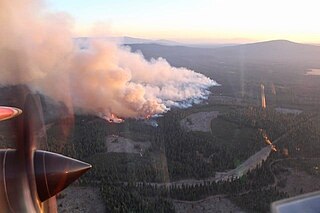
The Western United States experienced a series of major wildfires in 2020. Severe August thunderstorms ignited numerous wildfires across California, Oregon, and Washington, followed in early September by additional ignitions across the West Coast. Fanned by strong, gusty winds and fueled by hot, dry terrains, many of the fires exploded and coalesced into record-breaking megafires, burning more than 10.2 million acres of land, mobilizing tens of thousands of firefighters, razing over ten thousand buildings, and killing at least 37 people. The fires caused over $19.884 billion in damages, including $16.5 billion in property damage and $3.384 billion in fire suppression costs. Climate change and poor forest management practices contributed to the severity of the wildfires.

<span class="mw-page-title-main">El Dorado Fire</span> 2020 wildfire in Southern California

The El Dorado Fire was a wildfire that burned 22,744 acres in San Bernardino and Riverside counties of California from September to November 2020. It was ignited on September 5 by a pyrotechnic device at a gender reveal party in El Dorado Ranch Park; it quickly spread to the San Gorgonio Wilderness Area of the San Bernardino National Forest. Burning over a 71-day period, the fire destroyed 20 structures and resulted in one firefighter fatality, for which the couple hosting the party were charged with involuntary manslaughter.

<span class="mw-page-title-main">2020 Lassen County wildfires</span> 2020 wildfire sub-season that burned in Lassen County

The 2020 Lassen County wildfire season included seven large wildfires that burned entirely or in part in Lassen County. A total of 203,296 acres (82,271 ha) of land was burned in Lassen County, making it one of the larger clusters of fires in the 2020 California wildfire season.

<span class="mw-page-title-main">2021 Arizona wildfires</span> Wildfires in Arizona during spring and summer 2021

The 2021 Arizona wildfire season was a series of wildfires that burned across the state of Arizona, United States. Wildfires across the state burned 524,428 acres (212,228 ha) of land in at least 1,773 fires throughout the state, fueled in part by a drought, hot temperatures, and thunderstorms producing dry lightning. At one point in late June, over 20 active wildfires were burning across the state.

<span class="mw-page-title-main">2020 Maricopa County wildfires</span>

The 2020 Maricopa County wildfires were a series of major and non-major wildfires that took place in Maricopa County, Arizona, from the month of May to the month of October. In the year 2020, Arizona saw one of its worst fire seasons in the states history. Due to the lack of precipitation needed in Arizona, the state fell into an ongoing drought from late 2020 and 2021. High winds were also present during the summer when fire season is mostly active in the state. These factors led to the wildfires in Maricopa County to be destructive and costly.

References

  1. "Apple Fire". InciWeb. Archived from the original on December 9, 2020. Retrieved December 9, 2020.
  2. "Apple Fire". CAL FIRE . Archived from the original on September 22, 2020. Retrieved July 31, 2020.
  3. 1 2 3 City News Service (August 2020). "Apple fire grows to 1,900 acres, threatens homes in Cherry Valley". The SB Sun . Archived from the original on August 14, 2020. Retrieved August 1, 2020.
  4. Hahn, Jason. "Thousands of Californians Evacuate as Apple Fire Burns Through More Than 26,000 Acres". PEOPLE.com. Archived from the original on August 4, 2020. Retrieved August 4, 2020.
  5. Wigglesworth, Alex; Newberry, Laura (August 2, 2020). "Editor". Los Angeles Times. Archived from the original on August 3, 2020. Retrieved August 3, 2020.
  6. "California's Apple fire was sparked by malfunctioning diesel vehicle, officials say". the Guardian. Associated Press. August 4, 2020. Archived from the original on August 4, 2020. Retrieved August 4, 2020.
  7. 1 2 Wilkinson, Joseph (August 2020). "Almost 8,000 people ordered to evacuate and 4,100 acres toasted as Apple Fire in California burns without containment". NY Daily News . Archived from the original on August 11, 2020. Retrieved August 2, 2020.
  8. Miller, Leila (August 2020). "Apple fire grows to 1,900 acres in Riverside County, triggering evacuations". LA Times . Archived from the original on August 1, 2020. Retrieved August 1, 2020.
  9. ABC 7 News Staff (August 2020). "Brush fire quickly burns 1,720 acres in Cherry Valley area of Riverside County, prompting mandatory evacs". ABC 7 Eyewitness News . Archived from the original on August 1, 2020. Retrieved August 1, 2020.{{cite web}}: CS1 maint: numeric names: authors list (link)
  10. Selva, Jenn; Levenson, Eric (August 2, 2020). "Over 7,000 people evacuated due to the Apple Fire in Southern California". CNN . Archived from the original on August 2, 2020. Retrieved August 2, 2020.
  11. Riverside County Fire Department, CAL FIRE Co [@CALFIRERU] (August 2, 2020). "Update 1:00 a.m. 08/02/20 - The Apple Fire is now 15,000 acres and remains 0% contained. Several EVACUATION ORDERS and warnings remain in place" (Tweet) via Twitter.
  12. Fedschun, Travis (August 2, 2020). "Apple Fire in California explodes to more than 32 square miles, thousands evacuated". New York Post . Archived from the original on August 3, 2020. Retrieved August 2, 2020.
  13. Hayden, Colin Atagi, Amanda Ulrich and Nicole. "California's Apple fire scorches 20,500 acres and is 5% contained; smoke seen as far as Arizona". USA TODAY. Archived from the original on August 3, 2020. Retrieved August 3, 2020.{{cite web}}: CS1 maint: multiple names: authors list (link)
  14. "Apple Fire | Welcome to CAL FIRE". www.fire.ca.gov. Archived from the original on September 22, 2020. Retrieved August 3, 2020.
  15. "Apple Fire Information - InciWeb the Incident Information System". inciweb.nwcg.gov. Archived from the original on December 9, 2020. Retrieved August 3, 2020.
  16. "Apple Fire Information - InciWeb the Incident Information System". inciweb.nwcg.gov. Archived from the original on December 9, 2020. Retrieved August 4, 2020.
  17. "Apple Fire Information - InciWeb the Incident Information System". inciweb.nwcg.gov. Archived from the original on December 9, 2020. Retrieved August 5, 2020.
  18. "Apple Fire Information - InciWeb the Incident Information System". inciweb.nwcg.gov. Archived from the original on December 9, 2020. Retrieved August 6, 2020.
  19. Newell, Shane; Brian, Blueskye. "One home destroyed as Apple Fire grows to 1,900 acres in Cherry Valley along Oak Glen Road, officials say". The Desert Sun . Archived from the original on August 1, 2020. Retrieved August 1, 2020.
  20. NBC4 News Staff (August 2020). "Cherry Valley Fires Burn Almost 2,000 Acres, Force Evacuations". NBC 4 News . Archived from the original on November 1, 2023. Retrieved August 1, 2020.{{cite web}}: CS1 maint: numeric names: authors list (link)
  21. "Apple Fire | Welcome to CAL FIRE". www.fire.ca.gov. Archived from the original on September 22, 2020. Retrieved August 5, 2020.
  22. 1 2 Atagi, Colin; Ulrich, Amanda; Hayden, Nicole; Plevin, Rebecca; Sestito, Maria; Damien, Christopher. "'Hot objects' from vehicle tailpipe caused 26,850-acre Apple Fire in California, authorities say". USA Today . Archived from the original on August 6, 2020. Retrieved August 3, 2020.
  23. 1 2 3 DeAtley, Richard (August 3, 2020). "Apple fire caused by diesel vehicle's exhaust system, investigators say". Inland Valley Daily Bulletin . Archived from the original on August 16, 2020. Retrieved August 3, 2020.

PD-icon.svg This article incorporates text from https://www.fire.ca.gov/incidents/2020/7/31/apple-fire/, a public domain work of the Government of California.