


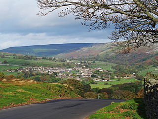
Applegarth is a historic settlement located north of the River Swale in Yorkshire, England. It lies about three-quarters of a mile north-east of the village of Marske. [1]
Applegarth is a historic settlement located north of the River Swale in Yorkshire, England. It lies about three-quarters of a mile north-east of the village of Marske. [1]
Applegarth now encompasses West Applegarth, High Applegarth, East Applegarth, Low Applegarth and Applegarth Low Wood, and includes the limestone crag of Applegarth Scar. [1] Applegarth bridleway runs along the valley through the settlement, and is still a bridleway despite an attempt to have it downgraded in 2010. [2]
The name Applegarth has Norse origins. [3] A mansion stood on the site now occupied by West Applegarth farm, and the land to the north of Applegarth Scar was wild forest, with wolves and fallow deer. [4] Applegarth was part of the manor of Ravensworth which belonged for many years to the FitzHughs. [4] Applegarth Forest was described as picturesque and delightful in 1791. [5]
In 1250, free warren in Applegarth was granted to Henry, son of Ralph de Ravenswath, and at the time of Kirkby's Inquest of 1284, Robert de Applegarth, a bailiff of Richmond, held a carucate of land at Applegarth under Hugh Fitz Henry. The FitzHughs continued to own Applegarth until the sixteenth century, when it passed to William Parr, 1st Marquess of Northampton. Parr granted Applegarth to a faithful retainer, Thomas son of Geoffrey Middleton, who lived there with his wife and large family. Thomas died in 1565, and the inventory of his effects includes eleven horses, fifteen cows, silver plate, his best suit of yellow satin and two other suits, his coat of steel and a crimson velvet coat of cloth of gold. [4]
When Parr died without heir in 1571, the manor of Ravenswath, including Applegarth, passed to the crown, and King Charles I granted the estate to the citizens of London in 1629, who sold it to two brothers, Jerome and John Robinson of St. Trinians, near Richmond. John resided in Applegarth for some time and died in 1656. His granddaughters sold Applegarth in 1675 to Sir Thomas Wharton, from whom it passed to Elizabeth Byerley in 1764, then to her five cousins. It was subsequently sold to James Hutchinson MD in 1788, then to John Hutton in 1814. [4]
Swaleview Caravan Park is close to East Applegarth Farm and near to the River Swale, and dates from the 1960s. [6]

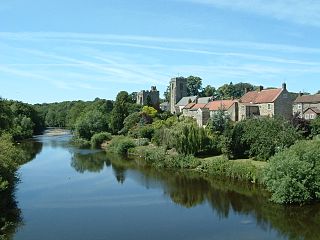
Richmond is a market town and civil parish in North Yorkshire, England and the administrative centre of the district of Richmondshire. Historically in the North Riding of Yorkshire, it is 16 miles (26 km) from the county town of Northallerton and situated on the eastern edge of the Yorkshire Dales National Park, and is one of the park's tourist centres. The population of Richmond according to the 2011 United Kingdom census is 8,413.

Richmondshire is a local government district of North Yorkshire, England. It covers a large northern area of the Yorkshire Dales including Swaledale and Arkengarthdale, Wensleydale and Coverdale, with the prominent Scots' Dyke and Scotch Corner along the centre. Teesdale lies to the north. With a total area of 1,319 km2, it is larger than seven of the English ceremonial counties.

Bedale is a market town and civil parish in the district of Hambleton, North Yorkshire, England. Historically part of the North Riding of Yorkshire, it is situated 34 miles (55 km) north of Leeds, 26 miles (42 km) south-west of Middlesbrough and 7 miles (11 km) south-west of the county town of Northallerton. It was originally in Richmondshire and listed in the Domesday Book as part of Catterick wapentake, which was also known as Hangshire ; it was split again and Bedale remained in East Hang. Bedale Beck is a tributary of the River Swale, which forms one of the Yorkshire Dales, with its predominance of agriculture and its related small traditional trades, although tourism is increasingly important.
Northern Rock, formerly the Northern Rock Building Society, was a British bank. Based at Regent Centre in Newcastle upon Tyne, United Kingdom, Northern Rock was originally a building society. It demutualised and became Northern Rock bank in 1997, when it floated on the London Stock Exchange with the ticker symbol NRK. During the early 2000s the company borrowed substantially to fund mortgages, with the aim of ambitious growth, and also donated large amounts to charitable purposes and communities directly and through sponsorships. The global banking crisis beginning around 2007–08 meant that it was unable to produce income as expected from its loans, and was at risk of being unable to repay the amounts it had borrowed. The news that the bank had approached the government for support with its liquidity led within 24 hours to a public lack of confidence and concerns that savings were at risk, and the bank failed following a bank run as people rushed to withdraw their savings. It was the first British bank in 150 years to fail due to a bank run.

The River Swale in Yorkshire, England, is a major tributary of the River Ure, which becomes the River Ouse, that empties into the North Sea via the Humber Estuary. The river gives its name to Swaledale, the valley through which it flows.

Swaledale is one of the northernmost dales (valleys) in Yorkshire Dales National Park, located in northern England. It is the dale of the River Swale on the east side of the Pennines in North Yorkshire.
Reeth is a village 11 miles (18 km) west of Richmond in the Richmondshire district of North Yorkshire, England, in the civil parish of Reeth, Fremington and Healaugh. Historically part of the North Riding of Yorkshire, it is the principal settlement of upper Swaledale.

North Cowton is a village and civil parish, located in Richmondshire, North Yorkshire, England. It is 8 miles (13 km) north-west of the county town of Northallerton.

Arkengarthdale is a dale, or valley, on the east side of the Pennines in North Yorkshire, England. Running roughly north-west to south-east, it is the valley of the Arkle Beck, and is the northernmost of the Yorkshire Dales. It is a subsidiary dale to Swaledale, which it joins at Reeth. The history of the dale, its people, and farming, lead mining, and local crafts is displayed and documented in the Swaledale Museum in Reeth.

Bolton-on-Swale is a village and civil parish in the Richmondshire district of North Yorkshire, England. In 2015, North Yorkshire County Council estimated the population of the civil parish to be 70.

Ravensworth is a village and civil parish in the Holmedale valley, within the Richmondshire district of North Yorkshire, England. It is approximately 4.5 miles (7.2 km) north-west from Richmond and 10 miles (16 km) from Darlington. The parish has a population of 255, according to the 2011 Census.

Breamore is a village and civil parish near Fordingbridge in Hampshire, England. The parish includes a notable Elizabethan country house, Breamore House, built with an E-shaped ground plan. The Church of England parish church of Saint Mary has an Anglo-Saxon rood.

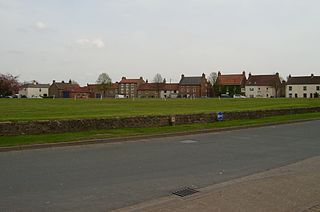
Marske is a village and civil parish in the Richmondshire district of North Yorkshire, England, situated in lower Swaledale on the boundary of the Yorkshire Dales National Park, the village is approximately 5 miles west of Richmond. According to the UK 2011 Census, the population of the parish of Marske, including New Forest was 127. The parish includes the hamlets of Applegarth, Clints, Feldom and Skelton.

Easby is a hamlet and civil parish in the Richmondshire district of North Yorkshire, England. It is situated near Richmond on the banks of the River Swale, approximately 12 miles (19 km) north west from the county town of Northallerton. The population taken by ONS was less than 100. Population information is included in the parish of Hudswell.
Scorton is a village and civil parish in the Richmondshire district of North Yorkshire, England. It is approximately 8 miles (13 km) north-west of the county town of Northallerton.
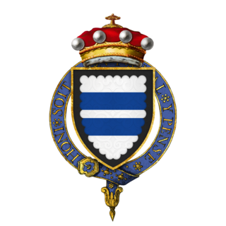
Sir William Parr, KG (1434–1483) was an English courtier and soldier. He was the eldest son of Sir Thomas Parr (1405–1461) and his wife Alice, daughter of Sir Thomas Tunstall of Thurland, Lancashire.

Danby Wiske is a village in the district of Hambleton in North Yorkshire, England. It is the main settlement in the civil parish of Danby Wiske with Lazenby. The village lies 3.7 miles (6 km) north north-west of the county town of Northallerton.
West Tanfield is a village and civil parish in the Hambleton district of North Yorkshire, England. The village is situated approximately six miles north of Ripon on the A6108, which goes from Ripon to Masham and Wensleydale. The parish includes the hamlets of Nosterfield, Thornborough and Binsoe.

Henry FitzHugh, 3rd Baron FitzHugh KG of Ravensworth Castle in North Yorkshire, was an administrator and diplomat who served under Kings Henry IV and Henry V.

In July 2019, parts of the Yorkshire Dales, in North Yorkshire, England, were subjected to above average rainfall for the time of year. The flash-flooding that followed affected many communities destroying bridges, sweeping roads away, causing landslips on railway lines and resulting in at least one public event being cancelled. The flooding even inundated the fire station in the town of Leyburn, in Wensleydale, whilst the crew were out helping those in need. The recovery took many weeks and months, with immediate help by the rescue services being bolstered by British Army personnel who assisted with the clean up.