Applegate Valley

Last updated
Image of Ruch, Oregon Ruch, Oregon.jpg
Image of Ruch, Oregon
A view of Applegate Valley from Woodrat Mountain Applegate.jpg
A view of Applegate Valley from Woodrat Mountain

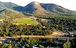
Applegate Valley is the valley of the Applegate River in Southern Oregon, United States and extending slightly into Northern California. It encompasses the area between Applegate and Grants Pass, generally 20 miles (30 km) west of Medford. Oregon Route 238 (Jacksonville Highway) is a main route through the valley.

Applegate River American river

The Applegate River is a 51-mile (82 km)-long tributary of the Rogue River in the U.S. state of Oregon. It drains approximately 698 square miles (1,810 km2). Rising in northern California, it soon crosses the border and flows northeast then northwest to meet the Rogue about 6 miles (9.7 km) west of Grants Pass. It drains forested foothills of the Siskiyou Mountains along the Oregon–California border.

Southern Oregon

Southern Oregon is a region of the U.S. state of Oregon south of Lane County and generally west of the Cascade Range, excluding the southern Oregon Coast. Counties include Douglas, Jackson, Klamath, and Josephine. It includes the Southern Oregon American Viticultural Area, which consists of the Umpqua and Rogue River drainages. As of 2015, the population in the four counties is about 471,000, and in the greater, seven-county definition is about 564,000.

United States federal republic in North America

The United States of America (USA), commonly known as the United States or America, is a country composed of 50 states, a federal district, five major self-governing territories, and various possessions. At 3.8 million square miles, the United States is the world's third or fourth largest country by total area and is slightly smaller than the entire continent of Europe's 3.9 million square miles. With a population of over 327 million people, the U.S. is the third most populous country. The capital is Washington, D.C., and the largest city by population is New York City. Forty-eight states and the capital's federal district are contiguous in North America between Canada and Mexico. The State of Alaska is in the northwest corner of North America, bordered by Canada to the east and across the Bering Strait from Russia to the west. The State of Hawaii is an archipelago in the mid-Pacific Ocean. The U.S. territories are scattered about the Pacific Ocean and the Caribbean Sea, stretching across nine official time zones. The extremely diverse geography, climate, and wildlife of the United States make it one of the world's 17 megadiverse countries.

Many wineries of the Applegate Valley AVA (American Viticultural Area), a sub-appellation of the Rogue Valley AVA, are located in the valley.

The state of Oregon in the United States has established an international reputation for its production of wine, ranking fourth in the country behind California, Washington, and New York. Oregon has several different growing regions within the state's borders that are well-suited to the cultivation of grapes; additional regions straddle the border between Oregon and the states of Washington and Idaho. Wine making dates back to pioneer times in the 1840s, with commercial production beginning in the 1960s.

Applegate Valley AVA

The Applegate Valley AVA is an American Viticultural Area located in southern Oregon. It is entirely contained within the Rogue Valley AVA, which is itself included within the larger Southern Oregon AVA. The region is named for the Applegate River, which flows through the town of Applegate and near the city of Jacksonville. One of Oregon's first wineries was established in the Applegate Valley. This region contains vineyards at altitudes ranging from 1,000 feet (300 m) to 1,500 feet (500 m) above sea level, and is warmer and drier than the Illinois Valley to the west, but less so than the Bear Creek Valley to the east. Grapes that thrive here include Tempranillo, Merlot, Cabernet Sauvignon, Syrah, Chardonnay, and Zinfandel, with Cabernet Sauvignon and Merlot being the dominant varietals.

American Viticultural Area designated wine grape-growing region in the United States

An American Viticultural Area (AVA) is a designated wine grape-growing region in the United States, providing an official appellation for the benefit of wineries.

The area is also a well known medical marijuana growing region.[ citation needed ]

See also

Coordinates: 42°19′N123°17′W / 42.32°N 123.29°W / 42.32; -123.29

Geographic coordinate system Coordinate system

A geographic coordinate system is a coordinate system that enables every location on Earth to be specified by a set of numbers, letters or symbols. The coordinates are often chosen such that one of the numbers represents a vertical position and two or three of the numbers represent a horizontal position; alternatively, a geographic position may be expressed in a combined three-dimensional Cartesian vector. A common choice of coordinates is latitude, longitude and elevation. To specify a location on a plane requires a map projection.


Related Research Articles

Applegate Trail emigrant trail in the western United States

The Applegate Trail was an emigrant trail through the present-day U.S. states of Idaho, Nevada, California, and Oregon used in the mid-19th century by emigrants on the American frontier. It was originally intended as a less dangerous alternative to the Oregon Trail by which to reach the Oregon Territory. Much of the route was coterminous with the California Trail.

Applegate, Oregon Unincorporated community in Oregon, United States

Applegate is an unincorporated community in Jackson County, Oregon, United States. It is west of Medford on Oregon Route 238 and the Applegate River. The community was probably named for Lindsay Applegate, who, along with his brothers Jesse and Charles, explored the Applegate Valley while blazing the Applegate Trail.

Willamette Valley AVA

The Willamette Valley AVA, is an American Viticultural Area which lies in the Willamette Valley of Oregon. The AVA is the wine growing region which encompasses the drainage basin of the Willamette River. It stretches from the Columbia River in the north to just south of Eugene in the south, where the Willamette Valley ends; and from the Oregon Coast Range in the west to the Cascade Mountains in the east. At 5,200 square miles (13,500 km2), it is the largest AVA in the state, and contains most of the state's wineries; approximately 200 as of 2006. The boundaries of the Willamette Valley AVA were established in 1984, and since then seven new, smaller AVAs have been created within the northern portion of Willamette Valley AVA. The Willamette Valley has a cool, moist climate, and is recognized worldwide for its Pinot noir.

Southern Oregon AVA

The Southern Oregon AVA, is an American Viticultural Area which lies in Southern Oregon, United States. The Southern Oregon AVA was established in 2004, and was created to include the land of two smaller AVAs, the Rogue Valley AVA and the Umpqua Valley AVA. Southern Oregon AVA was established to allow the two principal winegrowing regions in the southern part of the state to market themselves jointly. This creation of a "super-AVA" is a departure from the trend in the Willamette Valley AVA or northern Oregon of establishing smaller AVAs specific to a particular locale's climate or soil conditions.

Rogue Valley AVA

The Rogue Valley AVA is an American Viticultural Area located in southern Oregon. The federal government approved this appellation in 1991. It is entirely contained within the larger Southern Oregon AVA and includes the drainage basin of the Rogue River and several tributaries, including the Illinois River, the Applegate River, and Bear Creek. Most wineries in the region are found in the valleys formed by one of these three tributaries, rather than along the Rogue River itself. The region is 70 miles (113 km) wide by 60 miles (97 km) long ; there are fewer than 20 wineries with only 1,100 acres (450 ha) planted. Each river valley has a unique terroir, and grows different varieties of grapes. Overall, however, this region is the warmest and driest of Oregon's wine-growing regions.

Yamhill-Carlton District AVA

The Yamhill-Carlton AVA is an American Viticultural Area located in both Washington County and Yamhill County, Oregon. It is entirely contained within the Willamette Valley AVA, and surrounds the towns of Carlton and Yamhill. The mountain ridges surrounding the AVA form a horseshoe shape, and most of the vineyards are located on south-facing slopes. The AVA includes only land between 200 feet (61 m) and 1,000 feet (305 m) above sea level where marine sediments are some of the oldest soils in the Willamette Valley and create unique conditions for viticulture. The region is in the rain shadow of the 3,500 feet (1,100 m) Oregon Coast Range, a short distance to the west.

Ruch, Oregon Census-designated place in Oregon, United States

Ruch is an unincorporated community and census-designated place (CDP) in Jackson County, Oregon, United States. It is located on Oregon Route 238, southeast of Grants Pass. As of the 2010 census it had a population of 840.

Ribbon Ridge AVA

The Ribbon Ridge AVA is an American Viticultural Area in Yamhill County, Oregon. It is the smallest AVA in Oregon and is entirely contained within the Chehalem Mountains AVA, which in turn is entirely contained within the larger Willamette Valley AVA. Ribbon Ridge stretches between the towns of Newberg and Gaston. The ridge is defined by local geographic boundaries and an uplift of ocean sediment. It lies at 45° 21' N latitude and 123° 04' W longitude, at the northwest end of the Chehalem Mountains. The name originates in the 19th century. The ridge is approximately 0.25 miles (0.40 km) wide and 3.50 miles (5.63 km) long, and is 3,350 acres (1,356 ha) in area, with 500 acres (202 ha) planted on 20 vineyards. It is estimated that between 1,000 acres (405 ha) and 1,400 acres (567 ha) in the region is suitable for planting.

Bridgeview Vineyard and Winery

Bridgeview Vineyard and Winery is one of the largest wineries in Oregon. Located in Cave Junction, Oregon, Bridgeview is noted for their chardonnay, pinot gris and pinot noir. Its 85-acre (340,000 m2) estate in the Illinois Valley is planted in the European style of dense six-foot row and four-foot vine spacing. Bridgeview also has an 80-acre (320,000 m2) vineyard in the Applegate Valley.

Valley View Winery is a winery in the Applegate Valley AVA in Southern Oregon, United States, founded in 1972.

Eola-Amity Hills AVA

The Eola-Amity Hills AVA is an American Viticultural Area located in Polk County and Yamhill County, Oregon. It is entirely contained within the Willamette Valley AVA, and stretches from the city of Amity in the north to Salem in the south. The Eola and Amity hills cover an area west of the Willamette River approximately 15 miles (24 km) long by 6 miles (10 km) wide. The Eola-Amity Hills area benefits from steady winds off the Pacific Ocean that reach the Willamette Valley through the Van Duzer Corridor, a gap in the Oregon Coast Range, moderating the summer temperatures. The Eola Hills were named after the community of Eola, whose name was derived from Aeolus, the Greek god of the winds.

Bethel, Polk County, Oregon

Bethel is an unincorporated community in Polk County, Oregon, United States at the base of the Eola Hills in Plum Valley. Bethel is considered a ghost town as the only remaining structure is a school, now serving as a church. The locale was named by the Rev. Glen O. Burnett for a Church of Christ in Missouri where he had served as pastor. Bethel is a common name for churches as it is a Hebrew word that means "house of god". After traveling with his family on the Oregon Trail, Burnett settled on a Donation Land Claim in 1846. Burnett later rode circuit to the surrounding area, preaching in nearby communities, including Rickreall.

Camas Valley is an unincorporated community in Douglas County, Oregon, United States, in the valley of the same name. It is on Oregon Route 42, near the Middle Fork Coquille River.

Tenmile is an unincorporated community in Douglas County, Oregon, United States. It is located on Oregon Route 42 southwest of Roseburg.

Spring Valley (Oregon) valley in Polk County, Oregon, United States

Spring Valley is a valley in Polk County, Oregon, United States, situated north and east of the Eola Hills and west of the Willamette River. It corresponds roughly to the drainage of Spring Valley Creek. Populated places in Spring Valley include Zena and Lincoln. Oregon Route 221 passes along the east side of the valley, next to the Willamette River.

Holland is an unincorporated community in Josephine County, Oregon, United States. It is about eight miles southeast of Cave Junction, in the Illinois Valley south of Oregon Route 46.

Pleasant Valley is an unincorporated community in Josephine County, Oregon, United States. It is located about eleven miles north of Grants Pass, just west of Interstate 5. The community, which is located along the route of the Applegate Trail, is the site of a pioneer cemetery, and at one time it had a school.