Aq Kupruk | |
|---|---|
 Aq Kupruk Location in Afghanistan | |
| Coordinates: 36°5′0″N66°50′0″E / 36.08333°N 66.83333°E | |
| Country | |
| Province | Balkh Province |
| Time zone | + 4.30 |
Aq Kupruk is a village in Balkh Province in northern Afghanistan. [1]
Aq Kupruk | |
|---|---|
| Aq Kupruk Location in Afghanistan | |
| Coordinates: 36°5′0″N66°50′0″E / 36.08333°N 66.83333°E | |
| Country | |
| Province | Balkh Province |
| Time zone | + 4.30 |
Aq Kupruk is a village in Balkh Province in northern Afghanistan. [1]
Aq Kupruk(an Uzbek word meaning "white bridge")is also an archaeological site consisting of four sites, numbered I, II, III and IV.
Finds included an extensive and sophisticated stone tool industry, very early stone sculpture, domesticated sheep and goat remains, fragments of beaten copper from the ceramic Neolithic, many projectile points, terracotta and simple jewellery.
Collections:
Field-work:

The ancient history of Afghanistan, also referred to as the pre-Islamic period of Afghanistan, dates back to the Helmand Civilization around 3300–2350 BCE and the Oxus Civilization around 2400–1950 BCE. Archaeological exploration began in Afghanistan in earnest after World War II and proceeded until the late 1970s during the Soviet–Afghan War. Archaeologists and historians suggest that humans were living in Afghanistan at least 50,000 years ago, and that farming communities of the region were among the earliest in the world. Urbanized culture has existed in the land from between 3000 and 2000 BC. Artifacts typical of the Paleolithic, Mesolithic, Neolithic, Bronze, and Iron ages have been found inside Afghanistan.
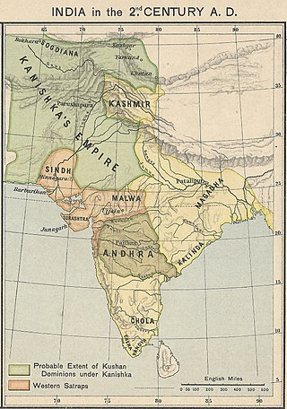
The Kushan Empire was a syncretic empire formed by the Yuezhi in the Bactrian territories in the early 1st century. It spread to encompass much of what is now Tajikistan, Uzbekistan, Afghanistan, Pakistan, Eastern Iran and Northern India, at least as far as Saketa and Sarnath, near Varanasi, where inscriptions have been found dating to the era of the Kushan emperor Kanishka the Great.
The Indo-Parthian Kingdom was a Parthian kingdom founded by Gondophares, and active from 19 CE to c. 226 CE. At their zenith, they ruled an area covering parts of eastern Iran, various parts of Afghanistan and the northwest regions of the Indian subcontinent. The rulers may have been members of the House of Suren, and the kingdom has even been called the "Suren Kingdom" by some authors.

Haḍḍa is a Greco-Buddhist archeological site located ten kilometers south of the city of Jalalabad, in the Nangarhar Province of eastern Afghanistan.
Ahmad Hassan Dani FRAS, SI, HI was a well known Pakistani archaeologist, historian, and linguist. He was among the foremost authorities on Central Asian and South Asian archaeology and history. He introduced archaeology as a discipline in higher education in Pakistan and Bangladesh. Throughout his career, Dani held various academic positions and international fellowships, apart from conducting archaeological excavations and research. He is particularly known for archaeological work on pre-Indus civilization and Gandhara sites in northern Pakistan.

Margiana is a historical region centred on the oasis of Merv and was a minor satrapy within the Achaemenid satrapy of Bactria, and a province within its successors, the Seleucid, Parthian and Sasanian empires.
The Kidarites, or Kidara Huns, were a dynasty that ruled Bactria and adjoining parts of Central Asia and South Asia in the 4th and 5th centuries. The Kidarites belonged to a complex of peoples known collectively in India as the Huna, and in Europe as the Chionites, and may even be considered as identical to the Chionites. The 5th century Byzantine historian Priscus called them Kidarite Huns, or "Huns who are Kidarites". The Huna/Xionite tribes are often linked, albeit controversially, to the Huns who invaded Eastern Europe during a similar period. They are entirely different from the Hephthalites, who replaced them about a century later.
The Kushano-Sasanian Kingdom was a polity established by the Sasanian Empire in Bactria during the 3rd and 4th centuries. The Sasanian Empire captured the provinces of Sogdia, Bactria and Gandhara from the declining Kushan Empire following a series of wars in 225 CE. The local Sasanian governors then went on to take the title of Kushanshah or "King of the Kushans", and to mint coins. They are sometimes considered as forming a "sub-kingdom" inside the Sasanian Empire.

Kot Bala, or Balakot is an archaeological site located in Lasbela District, Balochistan, Pakistan. It is near the Makran coast of the Arabian Sea, and goes back to around 4000 BC.

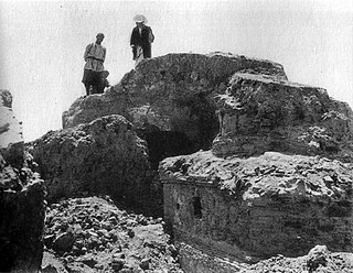
Surkh Kotal (Persian: چشمه شیر Chashma-i Shir; also called Sar-i Chashma, is an ancient archaeological site located in the southern part of the region of Bactria, about 18 kilometres north of the city of Puli Khumri, the capital of Baghlan Province of Afghanistan. It is the location of monumental constructions made during the rule of the Kushans. Huge temples, statues of Kushan rulers and the Surkh Kotal inscription, which revealed part of the chronology of early Kushan emperors were all found there. The Rabatak inscription which gives remarkable clues on the genealogy of the Kushan dynasty was also found in the Robatak village just outside the site.

Mundigak is an archaeological site in Kandahar province in Afghanistan. During the Bronze Age, it was a center of the Helmand culture. It is situated approximately 55 km (34 mi) northwest of Kandahar near Shāh Maqsūd, on the upper drainage of the Kushk-i Nakhud River.
Darra-e Kūr or Bābā Darwīsh, is an archaeological site in Badakhshan province in Afghanistan. It is situated just northeast of Kalafgān near the village of Chinār-i Gunjus Khān 63 km (39.1 mi) east of Taloqan, on the road to Faizabad. The cave is situated atop the side of the valley near the hamlet of Bābā Darwīsh.

Dilberjin Tepe, also Dilberjin or Delbarjin, is the modern name for the remains of an ancient town in modern (northern) Afghanistan. The town was perhaps founded in the time of the Achaemenid Empire. Under the Kushan Empire it became a major local centre. After the Kushano-Sassanids the town was abandoned.

Jeitun (Djeitun) is an archaeological site of the Neolithic period in southern Turkmenistan, about 30 kilometers north of Ashgabat in the Kopet-Dag mountain range. The settlement was occupied from about 7200 to 4500 BC possibly with short interruptions. Jeitun has given its name to the whole Neolithic period in the foothills of the Kopet Dag.

Sanghao Cave is a Paleolithic site, located on the Pothohar Plateau of Pakistan that was excavated by Ahmad Hasan Dani.
Yemshi Tepe, also Emchi-Tepe or Imshik, is an ancient circular fortress in Afghanistan, 5 kilometers to the northeast of the city of Sheberghan.It is about 100 kilometers west of Balkh, the capital of ancient Bactria.

Tapa Shotor, also Tape Shotor or Tapa-e-shotor, was a large Sarvastivadin monastery near Hadda, Afghanistan, and is now an archaeological site. According to archaeologist Raymond Allchin, the site of Tapa Shotor suggests that the Greco-Buddhist art of Gandhara descended directly from the art of Hellenistic Bactria, as seen in Ai-Khanoum.
Tepe Maranjan was a Buddhist monastery, located on the eastern outskirts of Kabul, and dated to the 4th century CE, or the 6-7th century for the Buddhist phase. Many Buddhist sculptures were discovered on the site. They are made of clay, and stylistically derived from the sculptures of Hadda, but preceded the style of the Fondukistan monastery. Tepe Maranjan can be considered as representative of the Art of Gandhara of the 5th or 6th century CE.
Said Qala Tepe is an archaeological site near Kandahar in Afghanistan. The tell is about 8 meters high and 200 by 200 meters in area. It has produced particularly strong evidence for the prehistoric period, showing an intensive settlement of the site in the fourth and third millennium BC, attributed to the Helmand culture.
The Sasanian–Kushan Wars were a series of wars between the newly established Persian Sasanian empire, under Ardashir I and later his successor Shapur I, against the declining Kushan empire. These wars resulted in the eastward expansion of the Sasanians who conquered much of the Kushan territory including Bactria, Gandhara and Sogdia. The Sassanids, shortly after victory over the declining Parthian empire, extended their dominion to most of former Parthian lands, including Bactria, during the reign of Ardashir I around 230 CE, then they further expanded to the eastern parts of their empire in what is now western Pakistan, at the expense of warring against the declining Kushan empire, during the reign of his son Shapur I (240–270). Thus the Kushans lost their western territory to the rule of Sassanid nobles, who eventually established their own states and were collectively referred to as Kushanshahs or "Kings of the Kushans". At their greatest extent, these Kushano-Sasanians also seem to have expanded eastwards all the way to Gandhara, however do not seem to have crossed the Indus river, since almost none of their coinage has been found in the city of Taxila, just beyond the Indus.