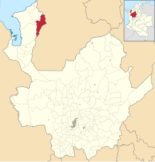
San Pedro de Urabá is a municipality in Antioquia Department, Colombia.

Grenadines is an administrative parish of Saint Vincent and the Grenadines, comprising the islands of the Grenadines other than those belonging to Grenada. The capital is Port Elizabeth.

Eastern Region is a region in eastern Iceland. Its area is 22,721 square kilometres (8,773 sq mi) and in 2020 its population was 13,173. The Eastern Regions has a jagged coastline of fjords, referred to as the Eastfjords.

Bala is a town and district of Ankara Province in the Central Anatolia region of Turkey, 67 km south-east of the city of Ankara. According to 2000 census, population of the district is 19,426 of which 8,506 live in the urban center of Bala. The district covers an area of 2,563 km2 (990 sq mi), and the average elevation is 1,310 m (4,298 ft).

The War in Darfur, also nicknamed the Land Cruiser War, is a major armed conflict in the Darfur region of Sudan that began in February 2003 when the Sudan Liberation Movement (SLM) and the Justice and Equality Movement (JEM) rebel groups began fighting the government of Sudan, which they accused of oppressing Darfur's non-Arab population. The government responded to attacks by carrying out a campaign of ethnic cleansing against Darfur's non-Arabs. This resulted in the death of hundreds of thousands of civilians and the indictment of Sudan's president, Omar al-Bashir, for genocide, war crimes, and crimes against humanity by the International Criminal Court.
Red Island is a former village about 12 miles northwest of Placentia, Newfoundland and Labrador in Placentia Bay. It had five families in 1864, and had a population of approximately 350 in the 1945 census.1 The village of 283 was depopulated in October 1968, during the provincial government's Resettlement Program. In modern times, many people have cabins there and use it as a summer retreat.

Skronina is a village in the administrative district of Gmina Białaczów, within Opoczno County, Łódź Voivodeship, in central Poland. It lies approximately 7 kilometres (4 mi) east of Białaczów, 14 km (9 mi) south-east of Opoczno, and 85 km (53 mi) south-east of the regional capital Łódź.
Hile is a village development committee in Baglung District in the Dhaulagiri Zone of central Nepal. At the time of the 1991 Nepal census it had a population of 2,891 and had 530 houses in the village. The town was founded in 1978.
Rzeszotków is a village in the administrative district of Gmina Paprotnia, within Siedlce County, Masovian Voivodeship, in east-central Poland. It lies approximately 16 kilometres (10 mi) north-east of Siedlce and 95 km (59 mi) east of Warsaw.
Uziębły is a village in the administrative district of Gmina Paprotnia, within Siedlce County, Masovian Voivodeship, near the eastern border of central Poland. It lies approximately 16 kilometres (10 mi) north-east of Siedlce and 95 km (59 mi) east of Warsaw.
Hét is a village in Borsod-Abaúj-Zemplén County in northeastern Hungary.
Chorbane is a town and commune in the Mahdia Governorate, Tunisia. As of 2004 it had a population of 5,849.
Kloodi is a village in Rakvere Parish, Lääne-Viru County, in northeastern Estonia.
Mount Gurage is a mountain located in central Ethiopia. It is the highest point in both the Gurage Zone and the entire Southern Nations, Nationalities, and Peoples' Region. The mountain has a latitude and longitude of 8°17′N38°23′E and an elevation of 3719 meters above sea level. To the north is the village of Anige, while to the east is Bu'i.
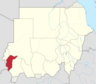
Central Darfur State is one of the states of Sudan, and one of five comprising the Darfur region. It was created in January 2012 as a result of the ongoing peace process for the wider Darfur region. The state capital is Zalingei. The state was formed from land that had been part of the states of West Darfur and South Darfur.
Ortacalar, Arhavi is a village in the District of Arhavi, Artvin Province, Turkey. As of 2010 it had a population of 39 people.
Üçler, Arhavi is a village in the District of Arhavi, Artvin Province, Turkey. As of 2010 it had a population of 88 people.

Konur is a village in Gülnar district of Mersin Province, Turkey. At 36°23′N33°17′E it is situated to the northwest of Gülnar. Its distance to Gülnar is 31 kilometres (19 mi) and to Mersin is 181 kilometres (112 mi). The population of Konur was 422 as of 2012.
Nasmah is a settlement in the former Mizda district of Libya. The village is at 31° 23' N, 13° 17' E. The tribe that populates the area is known as the "Awlad Abu seif".
Kulakpınar is a village in the Karacabey district of Bursa Province in Turkey.
