Archbald, Pennsylvania

Last updated
Archbald, Pennsylvania
White Oak Run
Borough
Archbald pothole.JPG
Archbald Pothole State Park
Lackawanna County Pennsylvania Incorporated and Unincorporated areas Archbald Highlighted.svg
Location of Archbald in Lackawanna County, Pennsylvania
USA Pennsylvania location map.svg
Red pog.svg
Archbald
Location of Archbald in Pennsylvania
Usa edcp location map.svg
Red pog.svg
Archbald
Archbald (the United States)
Coordinates: 41°30′23″N75°33′02″W / 41.506383°N 75.550512°W / 41.506383; -75.550512 Coordinates: 41°30′23″N75°33′02″W / 41.506383°N 75.550512°W / 41.506383; -75.550512
CountryUnited States
StatePennsylvania
County Lackawanna
Area
[1]
  Total17.10 sq mi (44.29 km2)
  Land17.09 sq mi (44.26 km2)
  Water0.01 sq mi (0.04 km2)
Elevation
[2]
1,079 ft (329 m)
Population
 (2020) [3]
  Total7,297
  Density427.02/sq mi (164.87/km2)
Time zone UTC-5 (EST)
  Summer (DST) UTC-4 (EDT)
ZIP code
18403 [4]
Area code 570
FIPS code 42-02832
GNIS feature ID1215313 [2]
Website Borough website

Archbald is a borough in Lackawanna County, Pennsylvania, United States. It is part of Northeastern Pennsylvania and is named for James Archbald, [5] the first mayor of Carbondale, Pennsylvania. Before being renamed in Archbald's honor, the name of the settlement was White Oak Run. Most of the original settlers were Irish Catholics, fleeing the Great Famine. [6] The population was 7,319 at the 2020 census. [7]

Contents

The village of Eynon is incorporated into Archbald.

Geography

Archbald is located at 41°30′23″N75°33′02″W / 41.506383°N 75.550512°W / 41.506383; -75.550512 . [8] According to the United States Census Bureau, the borough has a total area of 17.10 sqmi (44.29 km2), of which 17.09 smi (44.26 km2) is land and 0.014 sqmi (0.036 km2) (0.06%) is water.

Demographics

Historical population
CensusPop.Note
1870 2,571
1880 3,04918.6%
1890 4,03232.2%
1900 5,39633.8%
1910 7,19433.3%
1920 8,60319.6%
1930 9,58711.4%
1940 8,296−13.5%
1950 6,304−24.0%
1960 5,471−13.2%
1970 6,11811.8%
1980 6,2952.9%
1990 6,291−0.1%
2000 6,220−1.1%
2010 6,98412.3%
2020 7,2974.5%
2021 (est.)7,348 [7] 0.7%
Sources: [9] [10] [11] [12] [3]

2010 census

As of the 2010 United States Census [13] there were 6,984 people, 2,802 households, and 1,948 families in the borough. The population density was 408.7/sqmi (157.9/km²). There were 2,952 housing units at an average density of 173/sqmi (67.5/km²). The racial makeup of the borough was 96.9% White, 1.1% African American, 0.2% Native American, 0.7% Asian, 0.2% from other races, and 0.9% from two or more races. Hispanic or Latino of any race were 1.1% of the population.

There were 2,802 households, out of which 29% had children under the age of 18 living with them, 52.4% were married couples living together, 11.7% had a female householder with no husband present, 30.5% were non-families. 26% of all households were made up of individuals, and 12.5% had someone living alone who was 65 years of age or older. The average household size was 2.49 and the average family size was 3.0.

The borough population contained 22.9% under the age of 18, 60.3% from 18 to 64, and 16.8% who were 65 years of age or older. The median age was 42 years.

The median income for a household in the borough was $39,428, and the median income for a family was $52,410. Males had a median income of $36,913 versus $26,343 for females. The per capita income for the borough was $19,352. About 3.8% of families and 6.9% of the population were below the poverty line, including 3.7% of those under age 18 and 11.3% of those age 65 or over.

Education

Archbald was the home of Archbald High School until the class of 1969 graduated. Given population declines, in the fall of 1969 the boroughs of Archbald, Blakely, and Jessup combined their public school systems to form the Valley View School District.

Recreation

Archbald Pothole State Park is a 150-acre (0.61 km2) park in northeastern Pennsylvania. The park is named for Archbald Pothole, a geologic feature that formed during the Wisconsin Glacial Period, around 15,000 years ago. The pothole is 38 feet (12 m) deep and has an elliptical shape. The diameter of the pothole decreases downward. The largest diameter is 42 feet (13 m) by 24 feet (7.3 m). At the bottom it is 17 feet (5.2 m) by 14 feet (4.3 m). The pothole has a volume of about 18,600 cubic feet (530 m3), therefore it could hold approximately 140,000 gallons.

The Lackawanna River, designated as an American Heritage River in 1997, runs through Archbald Borough. The Pennsylvania Fish and Boat Commission classified sections of the river that runs through Archbald as Class A Wild Trout Waters, meaning the river supports and sustains an abundant amount of wild brown trout for anglers to catch.

Notable people

Related Research Articles

<span class="mw-page-title-main">Lincoln, Pennsylvania</span> Borough in Pennsylvania, United States

Lincoln is a borough in Allegheny County, Pennsylvania, United States. The population was 932 at the 2020 United States Census.

<span class="mw-page-title-main">Cassville, Pennsylvania</span> Borough in Pennsylvania, United States

Cassville is a borough in Huntingdon County, Pennsylvania, United States. As of the 2020 census, the borough population was 138.

<span class="mw-page-title-main">Waverly Township, Lackawanna County, Pennsylvania</span> Township in Pennsylvania, United States

Waverly Township is a township in Lackawanna County, Pennsylvania, United States. It is bordered by Dalton and Glenburn townships to the west, North Abington Township to the north, the boroughs of Clarks Summit and Clarks Green to the south, and South Abington Township to the south and southeast. Waverly Township is part of a suburban area known as "the Abingtons". The population was 1,861 at the 2020 census.

<span class="mw-page-title-main">Blakely, Pennsylvania</span> Borough in Pennsylvania, United States

Blakely is a borough in Lackawanna County, Pennsylvania, United States. It is part of Northeastern Pennsylvania. The population was 6,657 at the 2020 census.

<span class="mw-page-title-main">Clarks Green, Pennsylvania</span> Borough in Pennsylvania, United States

Clarks Green is a borough in Lackawanna County, Pennsylvania. It is part of Northeastern Pennsylvania. The population was 1,529 at the 2020 census.

<span class="mw-page-title-main">Dalton, Pennsylvania</span> Borough in Pennsylvania, United States

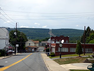
Dalton is a borough in Lackawanna County, Pennsylvania, United States. It is part of Northeastern Pennsylvania and is located approximately eight miles north of the city of Scranton in a suburban area known as "the Abingtons." Dalton is also approximately three miles north of Clarks Summit, the hub of the Abington community. The population was 1,283 at the 2020 census.

<span class="mw-page-title-main">Dickson City, Pennsylvania</span> Borough in Lackawanna County, Pennsylvania, United States

Dickson City is a borough in Lackawanna County, Pennsylvania, 4 miles (6 km) north of Scranton. Coal mining was an important industry in the past. The borough's population peaked at 12,395 in 1930 and was 6,051 at the 2020 census.

<span class="mw-page-title-main">Dunmore, Pennsylvania</span> Borough in Pennsylvania, United States

Dunmore is a borough in Lackawanna County, Pennsylvania, United States, adjoining Scranton. It is part of Northeastern Pennsylvania and was settled in 1835 and incorporated in 1862. Extensive anthracite coal, brick, stone, and silk interests had led to a rapid increase in the population from 8,315 in 1890 to 23,086 in 1940. The population was 14,042 in the 2020 census.

<span class="mw-page-title-main">Jermyn, Pennsylvania</span> Borough in Pennsylvania, United States

Jermyn, known as "The Birthplace of First Aid in America", is a borough which is located in Lackawanna County, Pennsylvania, United States. Located on the Lackawanna River, it is 12 miles (19 km) northeast of Scranton.

<span class="mw-page-title-main">Jessup, Pennsylvania</span> Borough in Pennsylvania, United States

Jessup is a borough in Lackawanna County, Pennsylvania, United States. The population was 4,532 at the 2020 census.

<span class="mw-page-title-main">Mayfield, Pennsylvania</span> Borough in Pennsylvania, United States

Mayfield is a borough in Lackawanna County, Pennsylvania, United States, approximately 14 miles (23 km) northeast of Scranton. In the past, it contained a silk mill and a coal mining industry. The population was 1,763 at the 2020 census.

<span class="mw-page-title-main">Moosic, Pennsylvania</span> Borough in Pennsylvania, United States

Moosic is a borough in Lackawanna County, Pennsylvania, United States, 3 miles (5 km) south of downtown Scranton and 10 miles (16 km) northeast of downtown Wilkes-Barre, on the Lackawanna River.

<span class="mw-page-title-main">Moscow, Pennsylvania</span> Borough in Pennsylvania, United States

Moscow is a borough in Lackawanna County, Pennsylvania, United States. The population was 2,039 at the 2020 census. It is located 11 miles (18 km) southeast of Scranton and 24 miles (39 km) southwest of Honesdale.

<span class="mw-page-title-main">North Abington Township, Lackawanna County, Pennsylvania</span> Place in Pennsylvania, United States

North Abington Township is a township in Lackawanna County, Pennsylvania, United States. It is located approximately 10 miles (16 km) north of Scranton, Pennsylvania, and is located in the suburban area known as “the Abingtons". North Abington is also approximately 6 miles (10 km) north of Clarks Summit and borders Waverly Township and Dalton Borough to the south, as well as Benton Township to the north. The population was 709 at the 2020 census.

<span class="mw-page-title-main">Scott Township, Lackawanna County, Pennsylvania</span> Place in Pennsylvania, United States

Scott Township is a township in the north central area of Lackawanna County, Pennsylvania, United States. As of the 2020 census, it had a population of 4,641.

<span class="mw-page-title-main">Taylor, Pennsylvania</span> Borough in Pennsylvania, United States

Taylor is a borough in Lackawanna County, Pennsylvania, United States, 3 miles (5 km) southwest of Scranton on the Lackawanna River. It was founded in 1790 by Cornelius Atherton. Silk manufacturing and coal mining were once practiced in the borough. Most of Taylor is built over abandoned mines. The Pennsylvania Turnpike Northeast Extension (I-476), accessible via the Keyser Avenue Interchange, passes through Taylor, going north to Clarks Summit and south to Philadelphia.

<span class="mw-page-title-main">Jeddo, Pennsylvania</span> Borough in Pennsylvania, United States

Jeddo is a borough in Luzerne County, Pennsylvania, United States. As of the 2020 census, the population was 109, making it the least populous borough in the county.

<span class="mw-page-title-main">Nicholson, Pennsylvania</span> Borough in Pennsylvania, United States

Nicholson is a borough in Wyoming County, Pennsylvania. The population was 698 at the 2020 census.

<span class="mw-page-title-main">Archbald Pothole State Park</span> State park in Lackawanna County, Pennsylvania.


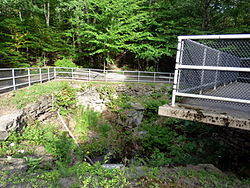
Archbald Pothole State Park is a 149.16-acre (60.36 ha) Pennsylvania state park in Archbald, Lackawanna County, Pennsylvania. The focal point of the park is Archbald Pothole. The pothole is a remnant of the Wisconsin Glacial Period, 38 feet (11.6 m) deep with a largest diameter of 42 feet (12.8 m) by 24 feet (7.3 m). It has drawn tourists since just after it was discovered in 1884. Archbald Pothole State Park is on U.S. Route 6 Business in the borough of Archbald.

<span class="mw-page-title-main">Valley View School District (Pennsylvania)</span> School district in Pennsylvania, U.S.

The Valley View School District is a small, suburban public school district located in Archbald, Lackawanna County, Pennsylvania. The school district serves: the boroughs of Archbald, Blakely, Jessup, the Peckville section of Blakely borough, and the Eynon section of Archbald borough, which are suburbs of Scranton. Valley View School District encompasses approximately 27 square miles (70 km2). According to 2004 local census data, it served a resident population of 17,715. By 2010, the district's population increased to 18,218 people. The educational attainment levels for the school district population were 88.7% high school graduates and 22.2% college graduates. The district is one of the 500 public school districts of Pennsylvania.

References

  1. "ArcGIS REST Services Directory". United States Census Bureau. Retrieved October 12, 2022.
  2. 1 2 U.S. Geological Survey Geographic Names Information System: Archbald, Pennsylvania
  3. 1 2 "Census Population API". United States Census Bureau. Retrieved Oct 12, 2022.
  4. "Archbald PA ZIP Code". zipdatamaps.com. 2023. Retrieved May 13, 2023.
  5. Hollister, Horace (1885). History of the Lackawanna Valley. Lippincott. p.  491.
  6. "Archbald Borough–History". Welcome to Archbald Borough. Computer Collaborative Team from Valley View High School. Archived from the original on 1 October 2011. Retrieved 12 October 2011.
  7. 1 2 Bureau, US Census. "City and Town Population Totals: 2020—2021". Census.gov. US Census Bureau. Retrieved August 5, 2022.
  8. "2017 US Gazetteer Files". United States Census Bureau . Retrieved March 24, 2019.
  9. "Census of Population and Housing: Decennial Censuses". US Census Bureau. Retrieved 4 March 2012.
  10. "Incorporated Places and Minor Civil Divisions Datasets: Subcounty Resident Population Estimates: April 1, 2010 to July 1, 2012". Population Estimates. US Census Bureau. Archived from the original on 11 June 2013. Retrieved 11 December 2013.
  11. "Archblad borough, Pennsylvania". census.gov. Retrieved July 7, 2022.
  12. "Census of Population and Housing". Census.gov. Retrieved June 4, 2016.
  13. "U.S. Census website". US Census Bureau. Retrieved 14 May 2011.
  14. New Haven Register. Son recounts father's day during bombing of Pearl Harbor.” Dec. 6, 2013. https://www.nhregister.com/connecticut/article/Son-recounts-father-s-day-during-bombing-of-11416239.php
  15. Proceedings of Army Pearl Harbor Board 2123. “Testimony of Joseph P. McDonald, Technician Fourth-Class; 580th Aircraft Warning; APO 958, c/o Postmaster, San Francisco, California.” http://www.ibiblio.org/pha/myths/radar/mcdonald_1.html
  16. Pearl Harbor Survivors. “Pearl Harbor Survivor. “Joseph P. McDonald.” http://pearlharborsurvivors.org/Memory/mcdonald.html
  17. James M Munley (US Courts)
  18. Marion L Munley (State Government - Biography)