Arco, Minnesota

Last updated

Arco
Lincoln County Minnesota Incorporated and Unincorporated areas Arco Highlighted.svg
Location of Arco
within Lincoln County, Minnesota
Coordinates: 44°23′01″N96°10′57″W / 44.38361°N 96.18250°W / 44.38361; -96.18250
Country United States
State Minnesota
County Lincoln
Area
[1]
  Total0.36 sq mi (0.93 km2)
  Land0.29 sq mi (0.75 km2)
  Water0.07 sq mi (0.18 km2)
Elevation
[2]
1,660 ft (510 m)
Population
 (2020)
  Total87
  Density300.00/sq mi (115.92/km2)
Time zone UTC-6 (Central (CST))
  Summer (DST) UTC-5 (CDT)
ZIP code
56113
Area code 507
FIPS code 27-01972 [3]
GNIS feature ID2393977 [2]

Arco is a city in Lincoln County, Minnesota, United States. The population was 75 at the 2010 census. [4]

Contents

History

Arco was platted in 1900, and named after Arcola, in Italy. [5] A post office has been in operation at Arco since 1900. [6]

The town was served by the Chicago & Northwestern railroad. The request to abandon the line from Tyler, Mn to Astoria, SD was approved on February 10, 1970. [7]

Geography

According to the United States Census Bureau, the city has a total area of 0.77 square miles (1.99 km2), of which 0.64 square miles (1.66 km2) is land and 0.13 square miles (0.34 km2) is water. [8]

Demographics

Historical population
CensusPop.Note
1910 97
1920 231138.1%
1930 185−19.9%
1940 24331.4%
1950 178−26.7%
1960 140−21.3%
1970 121−13.6%
1980 96−20.7%
1990 1048.3%
2000 100−3.8%
2010 75−25.0%
2020 8716.0%
U.S. Decennial Census [9]

2010 census

As of the census [10] of 2010, there were 75 people, 37 households, and 18 families residing in the city. The population density was 117.2 inhabitants per square mile (45.3/km2). There were 51 housing units at an average density of 79.7 per square mile (30.8/km2). The racial makeup of the city was 92.0% White and 8.0% from other races.

There were 37 households, of which 16.2% had children under the age of 18 living with them, 37.8% were married couples living together, 8.1% had a female householder with no husband present, 2.7% had a male householder with no wife present, and 51.4% were non-families. 45.9% of all households were made up of individuals, and 29.7% had someone living alone who was 65 years of age or older. The average household size was 2.03 and the average family size was 2.89.

The median age in the city was 49.5 years. 16% of residents were under the age of 18; 12% were between the ages of 18 and 24; 13.4% were from 25 to 44; 33.3% were from 45 to 64; and 25.3% were 65 years of age or older. The gender makeup of the city was 49.3% male and 50.7% female.

2000 census

As of the census [3] of 2000, there were 100 people, 44 households, and 28 families residing in the city. The population density was 154.6 inhabitants per square mile (59.7/km2). There were 51 housing units at an average density of 78.8 per square mile (30.4/km2). The racial makeup of the city was 98.00% White, 1.00% Native American, and 1.00% from two or more races.

There were 44 households, out of which 31.8% had children under the age of 18 living with them, 54.5% were married couples living together, 6.8% had a female householder with no husband present, and 34.1% were non-families. 31.8% of all households were made up of individuals, and 15.9% had someone living alone who was 65 years of age or older. The average household size was 2.27 and the average family size was 2.86.

In the city, the population was spread out, with 20.0% under the age of 18, 12.0% from 18 to 24, 27.0% from 25 to 44, 18.0% from 45 to 64, and 23.0% who were 65 years of age or older. The median age was 38 years. For every 100 females, there were 104.1 males. For every 100 females age 18 and over, there were 122.2 males.

The median income for a household in the city was $30,625, and the median income for a family was $31,875. Males had a median income of $21,875 versus $20,833 for females. The per capita income for the city was $13,479. There were 6.9% of families and 4.9% of the population living below the poverty line, including no under eighteens and 6.9% of those over 64.

Related Research Articles

<span class="mw-page-title-main">McGregor, Minnesota</span> City in Minnesota, United States

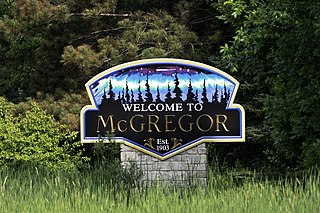
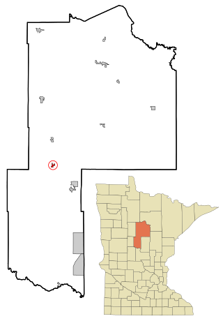
McGregor is a city in Aitkin County, Minnesota, United States. The population was 391 at the 2010 census.

<span class="mw-page-title-main">Ramsey, Minnesota</span> City in Minnesota, United States

Ramsey is a suburban city 22 miles (35 km) north-northwest of downtown Minneapolis in Anoka County, Minnesota, United States. The population was 27,646 at the 2020 census. It is a northwest suburb of the Twin Cities.

<span class="mw-page-title-main">Backus, Minnesota</span> City in Minnesota, United States

Backus is a city in Cass County, Minnesota, United States. The population was 250 at the 2010 census. It is part of the Brainerd Micropolitan Statistical Area.

<span class="mw-page-title-main">Deerwood, Minnesota</span> City in Minnesota, United States

Deerwood is a city in Crow Wing County, Minnesota, United States. The population was 526 at the 2020 census. It is part of the Brainerd Micropolitan Statistical Area.

<span class="mw-page-title-main">Isanti, Minnesota</span> City in Minnesota, United States

Isanti is a city in Isanti County, Minnesota, United States. The population was 6,804 at the 2020 census. The name Isanti is composed of two Dakota words: isan ("knife") and ati ("camp"), and refers to the Santee Dakota people.

<span class="mw-page-title-main">Lakefield, Minnesota</span> City in Minnesota, United States

Lakefield is a city in Jackson County, Minnesota, United States. The population was 1,694 at the 2010 census.

<span class="mw-page-title-main">Lake Bronson, Minnesota</span> City in Minnesota, United States

Lake Bronson is a city in Kittson County, Minnesota, United States. The population was 178 at the 2020 census. Lake Bronson State Park is nearby.

<span class="mw-page-title-main">Harding, Minnesota</span> City in Minnesota, United States

Harding is a city in Morrison County, Minnesota, United States, along the Platte River. The population was 123 at the 2020 census.

<span class="mw-page-title-main">Lastrup, Minnesota</span> City in Minnesota, United States

Lastrup is a city in Morrison County, Minnesota, United States. The population was 120 at the 2020 census.

<span class="mw-page-title-main">Dover, Minnesota</span> City in Minnesota, United States

Dover is a city in Olmsted County, Minnesota, United States. The population was 735 at the 2010 census.

<span class="mw-page-title-main">Bluffton, Minnesota</span> City in Minnesota, United States

Bluffton is a city in Otter Tail County, Minnesota, United States, along the Leaf River. The population was 210 at the 2020 census.

<span class="mw-page-title-main">Clitherall, Minnesota</span> City in Minnesota, United States

Clitherall is a city in Otter Tail County, Minnesota, United States. The population was 62 at the 2020 census.

<span class="mw-page-title-main">Henning, Minnesota</span> City in Minnesota, United States

Henning is a city in Otter Tail County, Minnesota, United States. The population was 854 at the 2020 census.

<span class="mw-page-title-main">Richville, Minnesota</span> City in Minnesota, United States

Richville is a city in Otter Tail County, Minnesota, United States. The population was 77 as of the 2020 census.

<span class="mw-page-title-main">Vergas, Minnesota</span> City in Minnesota, United States

Vergas is a city in northern Otter Tail County, Minnesota, United States. The population was 348 at the 2020 census.

<span class="mw-page-title-main">Ihlen, Minnesota</span> City in Minnesota, United States

Ihlen is a city in Pipestone County, Minnesota, United States. The population was 61 at the 2020 census.

<span class="mw-page-title-main">Grant, Minnesota</span> City in Minnesota, United States

Grant is a city in Washington County, Minnesota, and a suburb of St. Paul. The population was 4,096 at the time of the 2010 census.

<span class="mw-page-title-main">Meire Grove, Minnesota</span> City in Minnesota, United States

Meire Grove is a city in Stearns County, Minnesota, United States. The population was 179 at the 2010 census. It is part of the St. Cloud Metropolitan Statistical Area.

<span class="mw-page-title-main">Spring Hill, Minnesota</span> City in Minnesota, United States

Spring Hill is a city in Stearns County, Minnesota, United States. The population was 85 at the 2010 census. It is part of the St. Cloud Metropolitan Statistical Area.

<span class="mw-page-title-main">Ormsby, Minnesota</span> City in Minnesota, United States

Ormsby is a city in Martin and Watonwan counties in the U.S. state of Minnesota. The population was 131 at the 2010 census.

References

  1. "2020 U.S. Gazetteer Files". United States Census Bureau. Retrieved July 24, 2022.
  2. 1 2 U.S. Geological Survey Geographic Names Information System: Arco, Minnesota
  3. 1 2 "U.S. Census website". United States Census Bureau . Retrieved January 31, 2008.
  4. "2010 Census Redistricting Data (Public Law 94-171) Summary File". American FactFinder. United States Census Bureau . Retrieved April 27, 2011.[ dead link ]
  5. Upham, Warren (1920). Minnesota Geographic Names: Their Origin and Historic Significance. Minnesota Historical Society. p. 307.
  6. "Lincoln County". Jim Forte Postal History. Retrieved July 18, 2015.
  7. Alley, Michael (1980). "Branchline Abandonment: A study of the Impact on Selected Communities in Rural South Dakota".
  8. "US Gazetteer files 2010". United States Census Bureau. Archived from the original on January 25, 2012. Retrieved November 13, 2012.
  9. "Census of Population and Housing". Census.gov. Retrieved June 4, 2015.
  10. "U.S. Census website". United States Census Bureau . Retrieved November 13, 2012.