In the past Ardchattan has been co-joined with its neighbouring parish of Muckairn, on the other side of Loch Etive. Its most famous landmark is Ardchattan Priory, founded as a Valliscaulian priory around the year 1230. The priory's ruins and surrounding gardens are now open to the public.
Menteith or Monteith, a district of south Perthshire, Scotland, roughly comprises the territory between the Teith and the Forth. Earlier forms of its name include Meneted, Maneteth and Meneteth.
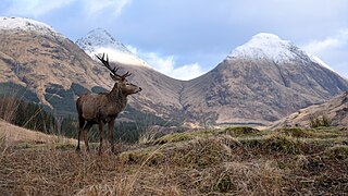
Glen Coe is a glen of volcanic origins, in the Highlands of Scotland. It lies in the north of the county of Argyll, close to the border with the historic province of Lochaber, within the modern council area of Highland. Glen Coe is regarded as the home of Scottish mountaineering and is popular with hillwalkers and climbers.
Loch Etive is a 30 km sea loch in Argyll and Bute, Scotland. It reaches the sea at Connel, 5 km north of Oban. It measures 31.6 km long and from 1.2 km to 1.6 km (1 mi) wide. Its depth varies greatly, up to a maximum of 150 m (490 ft).
Glen Etive is a glen in the Highlands of Scotland. The River Etive rises on the peaks surrounding Rannoch Moor, with several tributary streams coming together at the Kings House Hotel, at the head of Glen Coe. From the Kings House, the Etive flows for about 18 km, reaching the sea loch, Loch Etive. The river and its tributaries are popular with whitewater kayakers and at high water levels it is a test piece of the area and a classic run.
Balquhidder is a small village in Perthshire located 10 miles (16 km) north-west of Callander. It is administered by the Stirling council area of Scotland and is overlooked by the dramatic mountain terrain of the 'Braes of Balquhidder', at the head of Loch Voil. Balquhidder Glen is also popular for fishing, nature watching and walking.
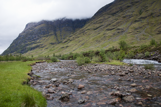
The River Coe rises at the north-eastern base of Buachaille Etive Beag in Scotland and flows west along Glen Coe. After dramatic waterfalls at the Pass of Glen Coe, it runs through the small Loch Achtriochtan before it turns north west. It then runs past the site of the Massacre of Glencoe and passes through Glencoe village, shortly before flowing into the sea loch of Loch Leven at Invercoe.
Bonawe is a village in Ardchattan Parish Argyll and Bute, Scotland opposite Taynuilt on the north shore of Loch Etive, most famous for the shipping firm J & A Gardener's Bonawe Quarry - now owned by Breedon Aggregates Scotland Ltd. Bonawe is primarily a linear settlement along on the B845 road and the coast. The iron furnace is at Bonawe in Glenorchy & Inishail Parish across Loch Etive nr Taynuilt in Muckairn Parish.
Taynuilt is a large village in Argyll and Bute, Scotland located at the western entrance to the narrow Pass of Brander.
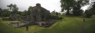
The Ardchattan Priory was a Valliscaulian monastic community in Ardchattan, Argyll, Scotland. It was founded in 1230 by Duncan MacDougal, Lord of Argyll. From the early 14th century, the Prior of Ardchattan held the chantership of Lismore Cathedral. In April 1510 it was incorporated as a cell of Beauly Priory and may have become Cistercian, but the evidence is slight. It was annexed to the bishopric of the Isles in 1615.
Donnchadh of Argyll or Donnchadh mac Dubhghaill was a late 12th and early 13th century Scottish noble. He was the son of Dubhghall mac Somhairle, son of Somhairle mac Gille Bhrighde. He is the first of the MacDougall lords of Argyll to take the title de Argadia, and can be regarded as the founder of the successful MacDougall lordship of Argyll. He was also a prominent builder, notable for his construction of Ardchattan Priory and Dunstaffnage Castle.
Inchfad is an island in the south east of Loch Lomond in Scotland.
Innis Chonain or Innischonan is an island in Loch Awe, Scotland connected to the mainland by a bridge.
Beinn Challuim is a mountain in the Breadalbane region of the Scottish Highlands. It is east of the village of Tyndrum, in the Forest of Mamlorn, an ancient deer forest at the northern edge of Loch Lomond and the Trossachs National Park. It is a Munro with a height of 1,025 metres (3,363 ft).
Creise is a mountain summit in the Black Mount range, in the Scottish Highlands. It overlooks the northern end of Glen Etive and its height is 1,100 metres (3,600 ft). Creise is one of four Munros in the Black Mount, along with Meall a' Bhuiridh, Stob Ghabhar and Stob a' Choire Odhair. The mountain is a long and flattish ridge, whose highest point was unnamed until 1981. It is popular with cross-country skiers, being near the White Corries ski area from where it is often climbed along with adjoining Meall a' Bhuiridh. The steep and craggy northern buttress, Sròn na Crèise, is well seen from the A82 road road and the Kings House Hotel.
Beinn Sgulaird or Beinn Sguiliaird is a mountain in the Lorn region of the Scottish Highlands, between Glen Creran and Glen Etive. It has a height of 937 m (3074 ft) and is classed as a Munro. The mountain takes the form of a long ridge which runs from southwest to northeast, three kilometres of which lie above 800 m. Hillwalkers commonly traverse the ridge from north to south, as this gives the best views of the Hebrides to the west, in particular the Isle of Mull. While most walkers start from Glen Creran to the west, an ascent from Glen Etive is also possible.
Ardpatrick is a village at the southwestern extremity of the Knapdale, Argyll, Scotland. The village is built along the north western shore of West Loch Tarbert.
Barcaldine House is a historic mansion in Barcaldine near Oban, Scotland, now a hotel.
The River Awe is a short river in the Southwest Highlands of Scotland by which the freshwater Loch Awe empties into Loch Etive, a sea loch. The river flows from a barrage which stretches across the end of a deep arm of the loch which protrudes northwestward through the Pass of Brander from the northeast–southwest aligned Loch Awe. The river is accompanied for much of its length both by the railway from Glasgow to Oban and by the A85 road both of which cross the river halfway along its length. The Awe is also crossed by a minor road bridge and a foot bridge.
Black Mount is a mountain range located in Argyll and Bute, Scotland. It is situated between Glen Orchy and Glen Coe. Its four Munros include Stob Ghabhar, Stob a' Choire Odhair, Creise and Meall a' Bhuiridh. The hills of Ben Inverveigh and Meall Tairbh are located between Black Mount and the Bridge of Orchy.
Ben Nevis and Glen Coe is a national scenic area (NSA) covering part of the Highlands of Scotland surrounding Ben Nevis and Glen Coe, in which certain forms of development are restricted. It is one of 40 such areas in Scotland, which are defined so as to identify areas of exceptional scenery and to ensure its protection from inappropriate development. The Ben Nevis and Glen Coe NSA covers 903 km2 (349 sq mi) of land, lying within the Highland, Argyll and Bute and Perth and Kinross council areas. A further 19 km2 (7.3 sq mi) of the NSA are marine, covering the sea loch of Loch Leven.
This page is based on this Wikipedia article Text is available under the CC BY-SA 4.0 license; additional terms may apply. Images, videos and audio are available under their respective licenses.


