Argyle Cut

Last updated

Argyle Cut
Argyle Cutting, The Rocks, Sydney (cropped, retouched).jpg
An c.1870s albumen photoprint of the Argyle Cut, looking west.
LocationArgyle Street, The Rocks, City of Sydney, New South Wales, Australia
Coordinates 33°51′32″S151°12′24″E / 33.8588°S 151.2066°E / -33.8588; 151.2066
Built18431868
Owner Sydney Harbour Foreshore Authority
Official nameArgyle Cut
Typestate heritage (built)
Designated10 May 2002
Reference no.1523
TypeRoad Embankment/Cutting
CategoryTransport – Land
BuildersConvict and paid labour
OSM central Sydney.png
Red pog.svg
Location of Argyle Cut in Sydney

The Argyle Cut is a heritage-listed roadway and road cutting located at Argyle Street in the inner-city Sydney suburb of The Rocks in the City of Sydney local government area of New South Wales, Australia. It was built from 1843 to 1868 with convict and paid labour. The property is owned by the Sydney Harbour Foreshore Authority, an agency of the Government of New South Wales. It was added to the New South Wales State Heritage Register on 10 May 2002. [1]

Contents

History

The Argyle Cut, looking east, pictured in c. 1900. Argyle Cut, Sydney from The Powerhouse Museum Collection.jpg
The Argyle Cut, looking east, pictured in c.1900.
Looking west through the Argyle Cut, below the Sydney Harbour Bridge approach, in 2022 In the Argyle Cut below the Sydney Harbour Bridge approach.jpg
Looking west through the Argyle Cut, below the Sydney Harbour Bridge approach, in 2022

Agitation for a link between The Rocks and Millers Point began early; the Sydney Gazette in 1803 lamented the lack of a short cut across the rocky peninsula. Maclehouse, in the Picture of Sydney and Strangers Guide in NSW for 1839, an early tourist guide, says that Argyle Street was in two parts. The eastern from George Street to Harrington Street separated by the western side by a "precipice of considerable height". At that stage a set of stairs which had once been cut into the rock to provide access between the two halves was already deteriorated and unsafe. Before the cut was built, the only way that vehicles could get from the Sydney Cove to Darling Harbour was via a circuitous route along lower George Street, to Dawes Point and into Windmill Street. For pedestrians, there was no other way except along the steep alleyways and flights of crude steps. [1]

As Darling Harbour developed, it became crucial for a link between the Cove and Millers Point. The first schemes came from private enterprise, with an ambitious plan to cut a deep channel through the central spine of The Rocks. The father of this plan was Alexander Berry, one of the wealthiest landowners and merchants in the colony. He had already presided over cutting a channel between the river and an arm of Crookhaven which became the virtual mouth of the Shoalhaven River. Besides his large landholding in the Shoalhaven, Berry had vast commercial interests in Sydney as an importer and exporter. His office was in Lower George Street, and he was vitally concerned about plans to extend Argyle Street. The proposal was that the shareholders should have the right to levy tolls on all passengers and stock using the cut, and from the revenue, the shareholders were to get a dividend. Any excess was to accumulate until it equalled the amount expended initially in the making of the cut. The capital was then to be returned to the shareholders, and the toll would cease. Governor Bourke and the Legislative Council turned down the plan, and the Government decided to undertake the work. [1]

A plan for the Argyle Cut was drawn up by the Government Architect, Edward Hallen, in 1832. The plan shows the proposed bridges over the streets above, a view, and the road's inclination. [1]

The Argyle Cut was begun by 1843, with convict labour in chain gangs. Their overseer was a cruel man, Tim Lane, who used to declare to the labourers that 'by the help of God and the strong arm of the flogger, you'll get fifty before breakfast tomorrow!' Despite his efforts, the job proved beyond the crude tools of the convicts. Transportation to NSW had ceased in 1840 after much agitation, and many of the residents were unsettled by the sight and sounds of convicts labouring in chains in full view. The Government abandoned the project when it was half completed. [1]

The cut was eventually completed by Sydney Municipal Council, using explosives and council labour in 1859. The spoil was used to fill the mouth of the Tank Stream and to buttress the sea wall at Circular Quay. Overhead bridges were built for Gloucester Street in 1862, Cumberland Street in 1864 and the Princes Street in 1867–68 (the latter demolished as part of the Sydney Harbour Bridge construction). [2] There is an inscription identifying Charles Moore, Mayor (1867–68) from this Bridge now relocated to the south wall of the cut. With the building of new wharves at Walsh Bay and the laying out of Hickson Road the Cut lost much of its importance. [1]

As part of the Sydney Harbour Trust's improvements in 1911-12, Gloucester and Cumberland Streets were realigned, and the two road bridges over the Argyle Cut replaced by a single bridge at Cumberland Street and the Argyle Stairs were constructed. This work involved the demolition of 22–24 Gloucester Street, part of View Terrace. [1]

Later, as part of the building of the Bradfield Highway in the 1920s, the Princes Street Bridge was demolished, and the Argyle Cut was widened at the Princes Street end, and the Bradfield Highway was constructed overhead, completed in 1932. [1]

Description

The Argyle Cut is a deep rock cutting giving a direct connection between Millers Point and The Rocks. It is covered by two bridges, the Cumberland Street bridge of c.1911 and the Bradfield Highway c.1930. On the wall of the Argyle Cut is an inscription that refers to the completion of the overhead bridges: completed 1867-1868, by Sydney Municipal Council, Charles Moore, mayor. [1]

Condition

As at 22 March 2004, the archaeological assessment of the cut was assessed as partly disturbed. [1]

Modifications and dates

The Cut was begun by 1843, and completed in 1859. Overhead bridges were built for Gloucester Street in 1862, Cumberland Street in 1864 and Princes Street in 1867–68. In 1911–12 Gloucester and Cumberland Streets were realigned and the two bridges replaced by a single bridge at Cumberland Street at the same time the Argyle Stairs were built. In the 1920s the Bradfield Highway was constructed, involving the demolition of the Princes Street bridge, widening the Cut at that end and the construction of a much larger bridge to accommodate the traffic from the Sydney Harbour Bridge. [1]

Heritage listing

As at 30 March 2011, Argyle Cut is of State heritage significance for its historical and scientific cultural values. The site is also of State heritage significance for its contribution to The Rocks area which is of State Heritage significance in its own right. The Argyle Cut has significance in that it is identified with the changing labour market in Sydney. It has associations with convict labour and the acceptance of responsibility of urban growth and public works by the Sydney Council. Argyle Cut has historical significance as an early east-west route across The Rocks, as an imposing example of convict public works, and as evidence, in its ongoing changes, crossings and widening, of improvements in the provision of access and infrastructure, including the work of the Sydney Harbour Trust and that for the construction of the Sydney Harbour Bridge and its approaches. It has aesthetic significance with the deep cutting providing a dramatic feature in Argyle Street. [1]

It has been ranked along with Busby's Bore and the building of Circular Quay as one of the most impressive engineering feats in early Sydney. The Argyle Cut has social significance as an important feature in The Rocks conservation area, and contributes strongly to the character of The Rocks. The Argyle cut is held in high esteem as indicated by its listings on the National Trust register and the Register of the National Estate, and thus is recognised by an identifiable group and has importance to the broader community. [1]

The Argyle Cut has significance from the links it derives with and support function associated with the development of a society in which it has sat for more than 150 years. The Argyle Cut has research potential for its association with town planning and street and urban development in early Sydney, and with the ongoing development of transportation systems within the city. The Argyle Cut is a rare example of early responses to the geographical difficulties presented to urban growth. The large spine of rock which cut the area into two was a barrier to the ease of transportation between two important and growing maritime and mercantile precincts. [1]

Argyle Cut was listed on the New South Wales State Heritage Register on 10 May 2002 having satisfied the following criteria. [1]

The place is important in demonstrating the course, or pattern, of cultural or natural history in New South Wales.

Argyle Cut has historical significance as an early east-west route across The Rocks, as an imposing example of convict public works, and as evidence, in its ongoing changes, crossings and widenings, of improvements in the provision of access and infrastructure, including the work of the Sydney Harbour Trust and that for the construction of the Sydney Harbour Bridge and its approaches. It has aesthetic significance with the deep cutting providing a dramatic feature in Argyle Street. It has been ranked along with Busby's Bore and the building of Circular Quay as one of the most impressive engineering feats in early Sydney. [1]

The place has a strong or special association with a person, or group of persons, of importance of cultural or natural history of New South Wales's history.

The Argyle Cut has significance in that it is identified with the changing labour market in Sydney. It has associations with convict labour and the acceptance of responsibility of urban growth and public works by the Sydney Council [1]

The place is important in demonstrating aesthetic characteristics and/or a high degree of creative or technical achievement in New South Wales.

It has been ranked along with Busby's Bore and the building of Circular Quay as one of the most impressive engineering feats in early Sydney. [1]

The place has a strong or special association with a particular community or cultural group in New South Wales for social, cultural or spiritual reasons.

The Argyle Cut has social significance as an important feature in The Rocks conservation area, and contributes strongly to the character of The Rocks. The Argyle cut is held in high esteem as indicated by its listings on the National Trust register and the Register of the National estate, and thus is recognised by an identifiable group and has importance to the broader community. The Argyle Cut has significance from the links it derives with and support function associated with the development of a society in which it has sat for more than 150 years. [1]

The place has potential to yield information that will contribute to an understanding of the cultural or natural history of New South Wales.

The Argyle Cut has research potential for its association with town planning and street and urban development in early Sydney, and with the ongoing development of transportation systems within the city. [1]

The place possesses uncommon, rare or endangered aspects of the cultural or natural history of New South Wales.

The Argyle Cut is a rare example of early responses to the geographical difficulties presented to urban growth. The large spine of rock which cut the area into two was a barrier to the ease of transportation between two important and growing maritime and mercantile precincts. [1]

See also

Related Research Articles

<span class="mw-page-title-main">The Rocks, New South Wales</span> Suburb of Sydney, New South Wales, Australia

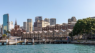
The Rocks is a suburb, tourist precinct and historic area of Sydney's city centre, in the state of New South Wales, Australia. It is located on the southern shore of Sydney Harbour, immediately north-west of the Sydney central business district.

<span class="mw-page-title-main">Australian Hotel</span> Historic site in New South Wales, Australia

The Australian Hotel is a heritage-listed hotel at 100–104 Cumberland Street, The Rocks, City of Sydney, New South Wales, Australia. The current structure was constructed from 1914 to 1915, and Property NSW owns the property, being added to the New South Wales State Heritage Register on 10 May 2002.

<span class="mw-page-title-main">Glenmore Hotel</span> Historic site in New South Wales, Australia

The Glenmore Hotel is a heritage-listed pub located at 96–98 Cumberland Street, in the inner city Sydney suburb of The Rocks in the City of Sydney local government area of New South Wales, Australia. It was designed by the Tooth and Co. resident architects and built in 1921 by D. M. Mitchell. The property is owned by Property NSW, an agency of the Government of New South Wales. It was added to the New South Wales State Heritage Register on 10 May 2002.

<span class="mw-page-title-main">Argyle Bridge</span> Bridge in New South Wales, Australia

The Argyle Bridge is a heritage-listed road bridge that carries Cumberland Street across the Argyle Cut and Argyle Street in the inner-city Sydney suburb of The Rocks in the City of Sydney local government area of New South Wales, Australia. It was built from 1911 to 1912. It is also known to include the Argyle Stairs. The property is owned by the Property NSW, an agency of the Government of New South Wales. It was added to the New South Wales State Heritage Register on 10 May 2002.

<span class="mw-page-title-main">Cumberland Street Archaeological Site</span> Historic site in New South Wales, Australia

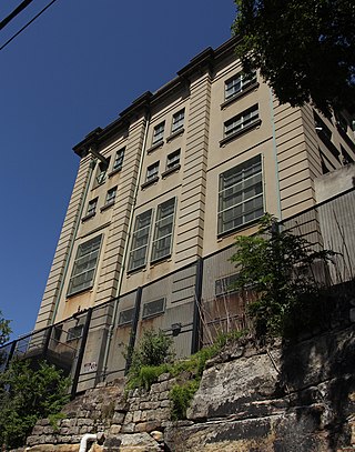
The Cumberland Street Archaeological Site is a heritage-listed archaeological site located at 106–128 Cumberland Street in the inner-city Sydney suburb of The Rocks in the City of Sydney local government area of New South Wales, Australia. The site includes the remains of early convict-era housing dating as far back as 1795, and a modern youth hostel has been built elevated over the remnants. It is also known as The Big Dig Site,Sydney YHA, and theBig Dig Education Centre. The property is owned by Property NSW, an agency of the Government of New South Wales, and it was added to the New South Wales State Heritage Register on 17 December 2010.

<span class="mw-page-title-main">NSW Housing Board Building, Grosvenor Street, The Rocks</span> Historic site in New South Wales, Australia

The NSW Housing Board Building is a heritage-listed former police station and government building and now commercial offices located at 16–18 Grosvenor Street in the inner city Sydney suburb of The Rocks in the City of Sydney local government area of New South Wales, Australia. It was designed by William Henry Foggitt and built in 1921 by J. McCarthy. It is also known as NSW Housing Board Building (former) and Charlotte House. The property is owned by Property NSW, an agency of the Government of New South Wales. It was added to the New South Wales State Heritage Register on 10 May 2002.

<span class="mw-page-title-main">Harts Buildings</span> Historic site in New South Wales, Australia

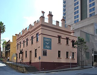
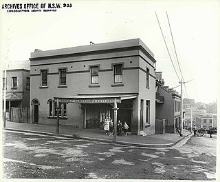
The Harts Buildings is a heritage-listed hotel and pub and former residence, located at 10–14 Essex Street, in the inner city Sydney suburb of The Rocks in the City of Sydney local government area of New South Wales, Australia. It was built from 1890 to 1899. It is also known as Hart's Buildings. The property is owned by Property NSW, an agency of the Government of New South Wales. It was added to the New South Wales State Heritage Register on 10 May 2002.

<span class="mw-page-title-main">Butchery Building</span> Historic site in New South Wales, Australia

The Butchery Building is a heritage-listed restaurant and former terraced houses and butcher's shop located at 178–180 Cumberland Street, in the inner city Sydney suburb of The Rocks in the City of Sydney local government area of New South Wales, Australia. It was built from 1890 to 1899. It is also known as The Butchery Buildings. The property is owned by Property NSW, an agency of the Government of New South Wales. It was added to the New South Wales State Heritage Register on 10 May 2002.

<span class="mw-page-title-main">Cumberland Place and Steps</span> Heritage-listed street in Sydney, Australia

The Cumberland Place and Steps are heritage-listed steps and a laneway located at Cumberland Place, in the inner city Sydney suburb of The Rocks in the City of Sydney local government area of New South Wales, Australia. It was built from 1807. It is also known as Suffolk Lane; Stubbs Lane; Gloucester Lane; and Cribb's Lane. The property is owned by Property NSW, an agency of the Government of New South Wales. It was added to the New South Wales State Heritage Register on 10 May 2002.

<span class="mw-page-title-main">182.5-188 Cumberland Street, The Rocks</span> Historic site in New South Wales, Australia

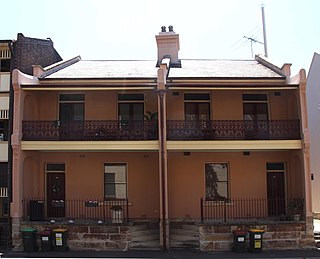
182.5–188 Cumberland Street, The Rocks are a series of heritage-listed terrace houses located at 182.5-188 Cumberland Street, in the inner city Sydney suburb of The Rocks in the City of Sydney local government area of New South Wales, Australia. It was built during 1890 by William John Finneran. The property is owned by Property NSW, an agency of the Government of New South Wales. It was added to the New South Wales State Heritage Register on 10 May 2002.

<span class="mw-page-title-main">Jobbins Terrace</span> Historic site in New South Wales, Australia

Jobbins Terrace is a series of heritage-listed terrace houses now repurposed as residences and offices located at 103–111 Gloucester Street, in the inner city Sydney suburb of The Rocks in the City of Sydney local government area of New South Wales, Australia. It was built from 1855 to 1857. It is also known as Longs Lane Terraces/Precinct . The property is owned by Property NSW, an agency of the Government of New South Wales. It was added to the New South Wales State Heritage Register on 10 May 2002.

<span class="mw-page-title-main">Long's Lane Precinct</span> Historic site in New South Wales, Australia

The Long's Lane Precinct, also Longs Lane Precinct, comprise a series of heritage-listed terrace houses located at 130 Cumberland Street, 132–134 Cumberland Street, 136-138 Cumberland Street, and 140–142 Cumberland Street, in the inner-city Sydney suburb of The Rocks in the City of Sydney local government area of New South Wales, Australia. The terrace houses were built from 1888 to 1914, and they are also known as 130 Cumberland Street,132–134 Cumberland Street, 136–138 Cumberland Street, Watson's Butchery, and 140–142 Cumberland Street. The properties are owned by NashCap, an Australian-based real estate private equity firm. The precinct and the terrace houses were added to the New South Wales State Heritage Register on 10 May 2002.

<span class="mw-page-title-main">113-115 Gloucester Street, The Rocks</span> Historic site in New South Wales, Australia

113–115 Gloucester Street, The Rocks is a heritage-listed terrace house located in the Long's Lane Precinct at 113–115 Gloucester Street, in the inner city Sydney suburb of The Rocks in the City of Sydney local government area of New South Wales, Australia. It was built during 1881. It is also known as Longs Lane Terraces/Precinct. The property is owned by Property NSW, an agency of the Government of New South Wales. It was added to the New South Wales State Heritage Register on 10 May 2002.

<span class="mw-page-title-main">117-117a Gloucester Street, The Rocks</span> Historic site in New South Wales, Australia

117–117a Gloucester Street, The Rocks is a heritage-listed terrace houses located in the Long's Lane Precinct at 117–117a Gloucester Street, in the inner city Sydney suburb of The Rocks in the City of Sydney local government area of New South Wales, Australia. It was designed by W. Foggitt and built from 1912 to 1915. It is also known as Longs Lane Terraces/Precinct (Long's). The property is owned by Property NSW, an agency of the Government of New South Wales. It was added to the New South Wales State Heritage Register on 10 May 2002.

<span class="mw-page-title-main">Baker's Terrace</span> Historic site in New South Wales, Australia

Baker's Terrace are heritage-listed commercial office buildings and former terrace houses located at 66–68 and 70–72 Gloucester Street, in the inner city Sydney suburb of The Rocks in the City of Sydney local government area of New South Wales, Australia. It was built during 1875 for William Andrews and Edward Baker. It is also known as Bakers Terrace. The property is owned by Property NSW, an agency of the Government of New South Wales. It was added to the New South Wales State Heritage Register on 10 May 2002.

<span class="mw-page-title-main">View Terrace facades</span> Historic site in New South Wales, Australia

The View Terrace facades are heritage-listed offices and a former residence and terrace houses located at 26–30 Gloucester Street, in the inner city Sydney suburb of The Rocks in the City of Sydney local government area of New South Wales, Australia. It was built from 1893 to 1893. It is also known as Formerly 22–30 Gloucester Street and part of 40 Gloucester Street development. The property is owned by Property NSW, an agency of the Government of New South Wales. It was added to the New South Wales State Heritage Register on 10 May 2002.

<span class="mw-page-title-main">Sydney Cove West Archaeological Precinct</span> Historic site in New South Wales, Australia

Sydney Cove West Archaeological Precinct is a heritage-listed precinct that contains The Rocks police station, the Museum of Contemporary Art Australia, car park, parks, shops and roads located at 112–156 George Street, in the inner city Sydney suburb of The Rocks in the City of Sydney local government area of New South Wales, Australia. The precinct previously contained a commissariat store, Maritime Services Board offices, dockyard and Department of Labour & Industry offices. Buildings in the precinct were developed in various stages since 1797 to date, with heritage-listed buildings dating from 1797 to 1939. The precinct is also known as the Museum of Contemporary Art, Maritime Services Board, Colonial Government naval dockyard, Commissariat Stores, Colonial Hospital, Kings and Queens Wharf and First Fleet Park. The property is owned by Property NSW, an agency of the Government of New South Wales. It was added to the New South Wales State Heritage Register on 5 August 2011.

<span class="mw-page-title-main">Argyle Street Railway Substation</span> Historic site in New South Wales, Australia

The Argyle Street Railway Substation is a heritage-listed railway electric substation located at Trinity Avenue, in the inner city Sydney suburb of Millers Point in the City of Sydney local government area of New South Wales, Australia. It was built in 1932 by Dorman, Long and Co. It is also known as Sydney Harbour Bridge Substation. The property is owned by RailCorp, an agency of the Government of New South Wales. It was added to the New South Wales State Heritage Register on 2 April 1999.

<span class="mw-page-title-main">Millers Point & Dawes Point Village Precinct</span> Historic site in New South Wales, Australia

The Millers Point & Dawes Point Village Precinct is a heritage-listed retail shops that support harbour functions, office and urban residences located at Upper Fort Street, in the inner city Sydney suburb of Millers Point and Dawes Point in the City of Sydney local government area of New South Wales, Australia. It was built from 1788 to. It is also known as Millers Point, Goodye, Leightons Point, Jack the Millers Point, 'Dawes Point, Tar-ra, Parish St Philip, Flagstaff Hill, Cockle Bay Point, the Point and Fort Street. It was added to the New South Wales State Heritage Register on 28 November 2003. The precinct was formerly home to industrial buildings and urban residences.

Millers Point Conservation Area is a heritage-listed historic precinct at Millers Point, Sydney, City of Sydney, New South Wales, Australia. The property is owned by the New South Wales Land and Housing Corporation. It was added to the New South Wales State Heritage Register on 2 April 1999.

References

  1. 1 2 3 4 5 6 7 8 9 10 11 12 13 14 15 16 17 18 19 20 21 "Argyle Cut". New South Wales State Heritage Register . Department of Planning & Environment. H01523. Retrieved 14 October 2018. CC BY icon.svg Text is licensed by State of New South Wales (Department of Planning and Environment) under CC-BY 4.0 licence .
  2. de Vries Evans, 1983: 38-39.

Bibliography

Attribution

CC BY icon-80x15.png This Wikipedia article was originally based on Argyle Cut , entry number 1523 in the New South Wales State Heritage Register published by the State of New South Wales (Department of Planning and Environment) 2018 under CC-BY 4.0 licence , accessed on 14 October 2018.

Commons-logo.svg Media related to Argyle Cut at Wikimedia Commons