
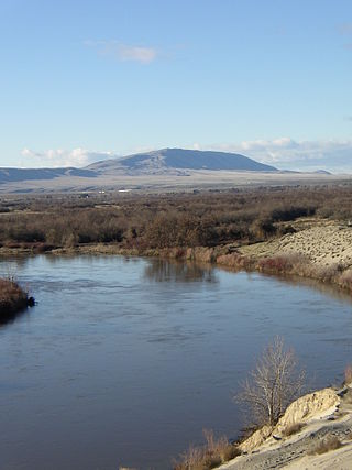
The Hanford Site is a decommissioned nuclear production complex operated by the United States federal government on the Columbia River in Benton County in the U.S. state of Washington. It has also been known as Site W and the Hanford Nuclear Reservation. Established in 1943 as part of the Manhattan Project, the site was home to the Hanford Engineer Works and B Reactor, the first full-scale plutonium production reactor in the world. Plutonium manufactured at the site was used in the first atomic bomb, which was tested in the Trinity nuclear test, and in the Fat Man bomb used in the bombing of Nagasaki.

Richland is a city in Benton County, Washington, United States. It is located in southeastern Washington at the confluence of the Yakima and the Columbia Rivers. As of the 2020 census, the city's population was 60,560. Along with the nearby cities of Pasco and Kennewick, Richland is one of the Tri-Cities, and is home to the Hanford nuclear site.

The Great Basin Desert is part of the Great Basin between the Sierra Nevada and the Wasatch Range. The desert is a geographical region that largely overlaps the Great Basin shrub steppe defined by the World Wildlife Fund, and the Central Basin and Range ecoregion defined by the U.S. Environmental Protection Agency and United States Geological Survey. It is a temperate desert with hot, dry summers and snowy winters. The desert spans large portions of Nevada and Utah, and extends into eastern California. The desert is one of the four biologically defined deserts in North America, in addition to the Mojave, Sonoran, and Chihuahuan Deserts.

Bromus tectorum, known as downy brome, drooping brome or cheatgrass, is a winter annual grass native to Europe, southwestern Asia, and northern Africa, but has become invasive in many other areas. It now is present in most of Europe, southern Russia, Japan, South Africa, Australia, New Zealand, Iceland, Greenland, North America and western Central Asia. In the eastern US B. tectorum is common along roadsides and as a crop weed, but usually does not dominate an ecosystem. It has become a dominant species in the Intermountain West and parts of Canada, and displays especially invasive behavior in the sagebrush steppe ecosystems where it has been listed as noxious weed. B. tectorum often enters the site in an area that has been disturbed, and then quickly expands into the surrounding area through its rapid growth and prolific seed production.
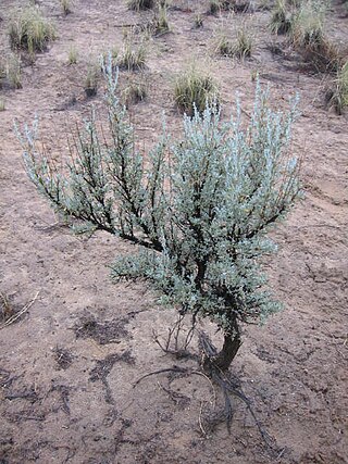
Artemisia tridentata, commonly called big sagebrush, Great Basin sagebrush or (locally) simply sagebrush, is an aromatic shrub from the family Asteraceae, which grows in arid and semi-arid conditions, throughout a range of cold desert, steppe, and mountain habitats in the Intermountain West of North America. The vernacular name "sagebrush" is also used for several related members of the genus Artemisia, such as California sagebrush.

Rangelands are grasslands, shrublands, woodlands, wetlands, and deserts that are grazed by domestic livestock or wild animals. Types of rangelands include tallgrass and shortgrass prairies, desert grasslands and shrublands, woodlands, savannas, chaparrals, steppes, and tundras. Rangelands do not include forests lacking grazable understory vegetation, barren desert, farmland, or land covered by solid rock, concrete and/or glaciers.

Sagebrush steppe is a type of shrub-steppe, a plant community characterized by the presence of shrubs, and usually dominated by sagebrush, any of several species in the genus Artemisia. This ecosystem is found in the Intermountain West in the United States.

The Coconino National Forest is a 1.856-million acre United States National Forest located in northern Arizona in the vicinity of Flagstaff, with elevations ranging from 2,600 feet to the highest point in Arizona at 12,633 feet. Originally established in 1898 as the "San Francisco Mountains National Forest Reserve", the area was designated a U.S. National Forest by Pres. Theodore Roosevelt on July 2, 1908, when the San Francisco Mountains National Forest Reserve was merged with lands from other surrounding forest reserves to create the Coconino National Forest. Today, the Coconino National Forest contains diverse landscapes, including deserts, ponderosa pine forests, flatlands, mesas, alpine tundra, and ancient volcanic peaks. The forest surrounds the towns of Sedona and Flagstaff and borders four other national forests; the Kaibab National Forest to the west and northwest, the Prescott National Forest to the southwest, the Tonto National Forest to the south, and the Apache-Sitgreaves National Forest to the southeast. The forest contains all or parts of nine designated wilderness areas, including the Kachina Peaks Wilderness, which includes the summit of the San Francisco Peaks. The headquarters are in Flagstaff. The Coconino National Forest consists of three districts: Flagstaff Ranger District, Mogollon Rim Ranger District, and Red Rock Ranger District, which have local ranger district offices in Flagstaff, Happy Jack, and Sedona.

Shrub-steppe is a type of low-rainfall natural grassland. While arid, shrub-steppes have sufficient moisture to support a cover of perennial grasses or shrubs, a feature which distinguishes them from deserts.

The Hanford Reach National Monument is a national monument in the U.S. state of Washington. It was created in 2000, mostly from the former security buffer surrounding the Hanford Nuclear Reservation. The area has been untouched by development or agriculture since 1943. Because of that it is considered an involuntary park.
Eberhardt is a Germanic surname. It may refer to:

Townsend's ground squirrel is a species of rodent in the family Sciuridae. It is found in high desert shrublands in several areas of the United States.
Rattlesnake Mountain is a 3,531 ft windswept treeless ridge overlooking the Hanford nuclear site. Parts of the western slope are privately owned ranchland, while the eastern slope is under the federal protection of the Arid Lands Ecology Reserve, a unit of the Hanford Reach National Monument, managed by the United States Fish and Wildlife Service. The mountain is the second highest point in Benton County, with its neighbor Lookout Summit surpassing it by only 98 ft.

The Columbia Plateau ecoregion is a Level III ecoregion designated by the United States Environmental Protection Agency (EPA) encompassing approximately 32,100 square miles (83,139 km2) of land within the U.S. states of Washington, Oregon, and Idaho. The ecoregion extends across a wide swath of the Columbia River Basin from The Dalles, Oregon to Lewiston, Idaho to Okanogan, Washington near the Canada–U.S. border. It includes nearly 500 miles (800 km) of the Columbia River, as well as the lower reaches of major tributaries such as the Snake and Yakima rivers and the associated drainage basins. It is named for the Columbia Plateau, a flood basalt plateau formed by the Columbia River Basalt Group during the late Miocene and early Pliocene. The arid sagebrush steppe and grasslands of the region are flanked by moister, predominantly forested, mountainous ecoregions on all sides. The underlying basalt is up to 2 miles (3 km) thick and partially covered by thick loess deposits. Where precipitation amounts are sufficient, the deep loess soils have been extensively cultivated for wheat. Water from the Columbia River is subject to resource allocation debates involving fisheries, navigation, hydropower, recreation, and irrigation, and the Columbia Basin Project has dramatically converted much of the region to agricultural use.

The Snake River Plain ecoregion is a Level III ecoregion designated by the United States Environmental Protection Agency (EPA) in the U.S. states of Idaho and Oregon. It follows the Snake River across Idaho, stretching roughly 400 miles (640 km) from the Wyoming border to Eastern Oregon in the xeric intermontane west. Characterized by plains and low hills, it is considerably lower and less rugged than surrounding ecoregions. Many of the alluvial valleys bordering the Snake River are used for agriculture. Where irrigation water and soil depth are sufficient, sugar beets, potatoes, alfalfa, small grains, and vegetables are grown. Elsewhere, livestock grazing is widespread. Cattle feedlots and dairy operations are found locally.

The Northern Basin and Range ecoregion is a Level III ecoregion designated by the United States Environmental Protection Agency (EPA) in the U.S. states of Oregon, Idaho, Nevada, Utah, and California. It contains dissected lava plains, rolling hills, alluvial fans, valleys, and scattered mountain ranges in the northern part of the Great Basin. Although arid, the ecoregion is higher and cooler than the Snake River Plain to the north and has more available moisture and a cooler climate than the Central Basin and Range to the south. Its southern boundary is determined by the highest shoreline of Pleistocene Lake Bonneville, which once inundated the Central Basin and Range. The western part of the region is internally drained; its eastern stream network drains to the Snake River system.

Savage Island lies on the last free flowing stretch of the Columbia River known as the Hanford Reach in Washington, United States; other interesting geological features of the area include the White Bluffs, as well across the river the Hanford Dunes. The island is within the boundaries of the Wahluke Wildlife Unit, a natural preserve managed by the US Fish and Wildlife Service as part of the Hanford Reach National Monument. Historically, Savage Island has supported small farms and settlements ranging from prior to the Manhattan Project buyout of the lands in 1943; The Wanapum tribe were known to inhabit this particular region. The wildlife of the island include mule deer, coyote, burrowing owl, and western diamondback rattlesnake; the island is primarily arid shrub steppe, with some wetland habitat by the shore of the river.
Wildfires consume live and dead fuels, destabilize physical and ecological landscapes, and impact human social and economic systems. Post-fire seeding was initially used to stabilize soils. More recently it is being used to recover post wildfire plant species, manage invasive non-native plant populations and establish valued vegetation compositions.
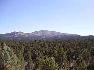
Pinyon–juniper woodland, also spelled piñon–juniper woodland, is a biome found mid-elevations in arid regions of the Western United States, characterized by being an open forest dominated by low, bushy, evergreen junipers, pinyon pines, and their associates which vary from region to region. At lower elevations, junipers often predominate and trees are spaced widely, bordering on and mingling with grassland or shrubland, but as elevation increases, pinyon pines become common and trees grow closer, forming denser canopies. Historically, pinyon-juniper woodland has provided a vital source of fuel and food for peoples of the American Southwest. These nuts have also provided a crucial source of food for species such as the Pinyon jay, which have become threatened as landowners have historically tried to convert large areas of pinyon-juniper woodland to grazing lands.

Locke Island is an island located in the Hanford Reach of the Columbia River in Washington, United States. The island is protected as part of the Hanford Reach National Monument, which was created out of lands surrounding the Hanford Site. The island is an important archeological site and is on the National Register of Historic Places. These cultural resources are being threatened by erosion resulting from a landslide changing the river's course.
