Ark (river boat)

Last updated
Three arks for a log drive on Pine Creek in Lycoming County or Tioga County. The left ark was for cooking and dining, the middle ark was the sleeping quarters, and the right ark was for the draft horses. The arks were built for just one trip down river and then dismantled and sold for their lumber. The line of the Jersey Shore, Pine Creek and Buffalo Railway can be seen on the eastern shore, and the mountainside behind it is nearly bare of trees from clear-cutting. Pine Creek Arks.jpg
Three arks for a log drive on Pine Creek in Lycoming County or Tioga County. The left ark was for cooking and dining, the middle ark was the sleeping quarters, and the right ark was for the draft horses. The arks were built for just one trip down river and then dismantled and sold for their lumber. The line of the Jersey Shore, Pine Creek and Buffalo Railway can be seen on the eastern shore, and the mountainside behind it is nearly bare of trees from clear-cutting.

In early periods of North American industrial development, an ark was a temporary boat used for river transport in eastern North America before slack-water canals (a lock system and appropriate dams allowing two way travel) and railroads made them obsolete. Because they could be built using relatively crude hand tools, arks were built in American colonial and early republic times, primarily to carry cargo downriver on the spring freshets, and especially to carry milled lumber, charcoal and other forest products and bulk agricultural produce to a city or a port downriver. While logs were often tied into rafts, on long trips which could take weeks, the rafts would be accompanied by such arks as crew support quarters. Deep rivers allowed large log arks as described below instead of less controllable rafts. Since by 1800, most eastern towns and cities were short on heating fuels, [1] even badly processed timber or planks could readily be sold at the destinations. [2]

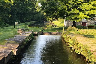
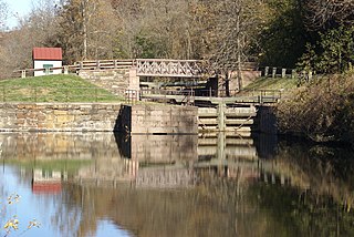
But it was in the role of delivering coal as a fuel to alleviate the long-standing first energy crisis [1] in the eastern United States that the arks saw their most frequent transport uses because of the 1816 invention of Josiah White's Bear Trap Lock system. The mechanisms allowed controllable artificially created freshets [3] which enabled the opening of the 45 miles (72 km) of the Lower Lehigh Canal (c.1818–1820), and thereby allowed the first extensive shipments of anthracite coal, the new high tech fuel to energy-starved industries in eastern cities. For a full decade ever increasing numbers were built and sent 105 miles (169 km) to the docks in Philadelphia.

By the time the long-delayed [lower-alpha 1] opening of the Delaware Canal reached partial operation in 1831 and it could switch to another form of river boat, the Lehigh Coal & Navigation Company was annually deforesting vast timber stands reaching by then more than 16 miles (26 km) upriver through the steep-banked waters of the Lehigh River Gorge to ship enough coal to meet demand in Philadelphia. Pennsylvania State Historian Fred Brenckman in The History of Carbon County notes that the production of ark river craft in 1831 by the LC&N would total over 13 miles (21 km) connected end to end. [4]

The boats used during the early years on the Lehigh consisted of square boxes, or arks, from sixteen to eighteen feet wide, and about twenty-five feet long.

At first two of these were joined together by means of hinges, to permit of the undulations produced in passing the dams and sluices. As the men became more expert in their work and as the channel was straightened and improved, the number of sections was increased till, finally, their whole length reached one hundred and eighty feet. They were steered with long oars, like a raft.

Boats of this description were used on the Lehigh to the end of the year 1831. During that year more than forty thousand tons of coal passed down the river, which required the building of so many boats that, had they all been joined in one length, they would have extended over a distance of more than thirteen miles.

Fred Brenckman, Official Historian of Pennsylvania, History of Carbon County (1884)

Upon arrival, the cargo was sold, the ark was dismantled and its lumber was also sold, and the ark pilots returned home on foot or horseback.

Despite the slowness of the craft, it was stable, and with a skilled crew was capable of maneuvering through fairly narrow points. Other river craft, usually the bateau, worked alongside the arks, ferrying the workers while the horses and bunks and supplies floated down the larger, stable structures.

Some arks in the Pennsylvania Canal System and Susquehanna River system were up to 75 feet (23 m) long, while the modular ark trains on the Lehigh Canal were coupled as long as 220 feet (67 m), [2] but could only navigate the descending locks half at a time. [2] [lower-alpha 2]

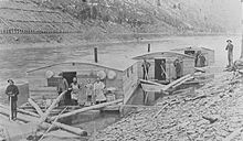
The arks within the Greenbrier River in West Virginia averaged sixty feet save for the larger cooking arks used to feed loggers four times a day. [5] The river ark was once a common sight along the Greenbrier River in West Virginia, with the spring floods bringing miles of white pine logs from Pocahontas County to Greenbrier County. Photographs of these massive vessels were posted along the Greenbrier River Trail at the town of Caldwell, West Virginia. These photographs illustrate integral scenes in W. E. Blackhurst's book, Riders of the Flood. The author based the plot along the world of the river logging era at the turn of the century within the area of the yet-to-be-created Monongahela National Forest. He had a meticulous interest in historical detail. In it he gives one of the clearest written descriptions of the river ark: [6]

The ark was built on a solid platform of logs. The heavy logs laid side by side formed a raft sixty feet long and twenty-four feet wide. Running crosswise at each four-foot interval, lash poles (lashing of hickory or locust) were placed. These were about six inch in diameter. At the point where the lash pole crossed each foundation log, a strong, U-shaped bow of bent white oak pinned it firmly to the log. The bows had been worked from straight lengths of oak one and a half inches square and bent to the U-shape. Both open ends were left square, and the body of the bow was shaved down and rounded. On each side of the lash pole, square holes had been cut deep into the foundation logs. Into these holes the squared ends were driven, thus bringing the bow down tight against the lash pole. A strong wedge of ash wood held each squared end tightly in place.

Lengthwise to the long platform, and resting across the lash poles, ran six-by-six sawed timbers. These formed the foundation for the low building that was erected on the raft. They were also the support for its plank floor. The building was a plain rectangular hut of sawed lumber nailed lengthwise to upright studding. The roof was not wedged, but rounding, an effect gained by the simple expedient of bending roof boards across in a distinct bow.

The building did not cover the entire raft floor. At each end, a six-foot length of space was left open, and along each side the walls were set in a scant two feet, leaving a narrow pathway alongside the building. On each of the four corners of the raft stood a sturdy post of peeled wood. These were the snubbing posts, and were thus placed so that the ark might be tied up from any corner. Seeing Duncan look closely at the posts, Warwick explained, "That's apple wood—the only wood we can find that won't grow rough from the chafing of a rope."

Duncan's interest was keenly aroused by the steering arrangement. On each end of the log platform was placed a short length of log, which was securely fastened to the logs beneath. Projecting upright on this base was a smooth, strong wooden pin. The top of the pin thrust up into the handle of the long steering sweep, thus forming a pivot point. The sweep could be swung from side to side, but always it rested securely on the smooth, upright pin.

The sweep itself was a long, tapered pole of about twenty-foot length. Six feet of the length at the small end projected across the pivoting pin onto the deck. The larger end lay out over the water. To the water end had been attached a broad wooden blade nearly ten feet long. To swing the heavy sweep and guide the cumbersome ark required the strength of two men at each of the sweep handles.

The little building was divided roughly into three parts. At each end were two stalls for horses. The center space was for the carrying of horse feed, harness, and tools, and for the sleeping quarters of the teamsters.

Every September the town of Ronceverte, West Virginia, hosts the play Riders of the Flood, based on the book of the same name. In it, a scaled-down mock-up version of a river ark is part of the set and is a backdrop for the historical accuracy of the project.

The village of Arkport, New York derives its name from this type of transport.

Notes

  1. Joshiah White had proved a ship canal compatible design by constructing four of them in the 1822 and 1823 rebuilding of ice damages; these would have handled period-typical sailing vessels over 30 feet (9.1 m) wide plus a steam tug. In mid-1823 LC&N then proposed, at its own expense, both to install such on the Delaware River and complete their upgrades of the Lehigh with compatible lockswhich would have allowed sea going shipping access to Mauch Chunk's slack water pool and the coal loading chutes at the end of the future Summit Hill and Mauch Chunk Railroad. But the Pennsylvania Legislature instead listened to timber interests, which generally floated large rafts of logs down river and feared dams would be an obstacle to their deliveries. They counter-proposed what became the Delaware Canal of the ambitious and comprehensive programs that established the Pennsylvania Canal System at great expense to LC&N from the great delay before it was ready. Ironically, the LC&N board, understanding the need to stop the costly business of building non-reusable boats, would end up floating many rafts of logs down to the building slips at Lausanne at the mouth of the Nesquehoning Creek above Mauch Chunk.
  2. While the Lehigh had larger locks, and White had wanted to build for ships plus tugs, the "on the cheap design" of the Delaware Canal [2] was designed with singleton locks of only 95 feet (29 m) by 10.5 feet (3.2 m) [2] costing Lehigh Coal & Navigation Company untold millions [2] over the 100 years it was used to deliver cargoes off the Lehigh.

Related Research Articles

<span class="mw-page-title-main">Beaver Meadows, Pennsylvania</span> Borough in Pennsylvania, United States

Beaver Meadows is a borough in Carbon County, Pennsylvania, United States. It is part of Northeastern Pennsylvania. The population was 897 at the 2020 U.S. census.

<span class="mw-page-title-main">Morris Canal</span> Canal in New Jersey

The Morris Canal (1829–1924) was a 107-mile (172 km) common carrier anthracite coal canal across northern New Jersey that connected the two industrial canals in Easton, Pennsylvania across the Delaware River from its western terminus at Phillipsburg, New Jersey to New York Harbor and New York City through its eastern terminals in Newark and on the Hudson River in Jersey City. The canal was sometimes called the Morris and Essex Canal, in error, due to confusion with the nearby and unrelated Morris and Essex Railroad.

<span class="mw-page-title-main">Anthracite iron</span> Substance created by the smelting together of anthracite coal and iron ore

Anthracite iron or anthracite pig iron is the substance created by the smelting together of anthracite coal and iron ore, that is using anthracite coal instead of charcoal to smelt iron ores—and was an important historic advance in the late-1830s, enabling a great acceleration of the industrial revolution in Europe and North America.

<span class="mw-page-title-main">Main Line of Public Works</span> United States historic place

The Main Line of Public Works was a package of legislation passed by the Commonwealth of Pennsylvania in 1826 to establish a means of transporting freight between Philadelphia and Pittsburgh. It funded the construction of various long-proposed canal and road projects, mostly in southern Pennsylvania, that became a canal system and later added railroads. Built between 1826 and 1834, it established the Pennsylvania Canal System and the Allegheny Portage Railroad.

<span class="mw-page-title-main">Schuylkill Canal</span>

The Schuylkill Canal, or Schuylkill Navigation, was a system of interconnected canals and slack-water pools along the Schuylkill River in the U.S. state of Pennsylvania, built as a commercial waterway in the early 19th-century. Chartered in 1815, the navigation opened in 1825, to provide transportation and water power.

Bateau Colonial flat-bottomed cargo boat

A bateau or batteau is a shallow-draft, flat-bottomed boat which was used extensively across North America, especially in the colonial period and in the fur trade. It was traditionally pointed at both ends but came in a wide variety of sizes. The name derives from the French word, bateau, which is simply the word for boat and the plural, bateaux, follows the French, an unusual construction for an English plural. In the southern United States, the term is still used to refer to flat-bottomed boats, including those elsewhere called jon boats.

<span class="mw-page-title-main">Pennsylvania Canal (Delaware Division)</span> United States historic place

The Delaware Division of the Pennsylvania Canal, more commonly called the Delaware Canal, runs for 60 miles (97 km) parallel to the right bank of the Delaware River from the entry locks near the mouth of the Lehigh River and terminal end of the Lehigh Canal at Easton south to Bristol. At Easton, which today is the home of The National Canal Museum, the Delaware Canal also connected with the Morris Canal built to carry anthracite coal to energy-starved New Jersey industries.

<span class="mw-page-title-main">Lehigh Canal</span> United States historic place

The Lehigh Canal is a navigable canal that begins at the mouth of Nesquehoning Creek on the Lehigh River in the Lehigh Valley and Northeastern regions of Pennsylvania. It was built in two sections over a span of 20 years beginning in 1818. The lower section spanned the distance between Easton and present-day Jim Thorpe. In Easton, the canal met the Delaware and Morris Canals, which allowed anthracite coal and other goods to be transported further up the U.S. East Coast. At its height, the Lehigh Canal was 72 miles (116 km) long.

<span class="mw-page-title-main">Lehigh Gorge State Park</span>

Lehigh Gorge State Park is a 4,548 acres (1,841 ha) Pennsylvania state park in Luzerne and Carbon Counties, Pennsylvania. The park encompasses a gorge, which stretches along the Lehigh River from a U.S. Army Corps of Engineers flood control dam in Luzerne County to Jim Thorpe in Carbon County. The primary recreational activity at Lehigh Gorge State Park is white water rafting.

The St. Lawrence Boom and Manufacturing Company was a lumber company based in Ronceverte, West Virginia. It was founded in 1802 by a Colonel Cecil C. Clay, a former US Army Brigadier-General from Philadelphia.

<span class="mw-page-title-main">Lehigh Coal & Navigation Company</span> Defunct mining and transportation company

The Lehigh Coal & Navigation Company was a mining and transportation company headquartered in Mauch Chunk, Pennsylvania, now known as Jim Thorpe in Northeastern Pennsylvania. The company operated from 1818 until its dissolution in 1964 and played an early and influential role in the rise of the American Industrial Revolution and early U.S. industrialization. The company ultimately encompassed source industries, transport, and manufacturing, making it the first vertically integrated U.S. company.

<span class="mw-page-title-main">Josiah White</span>

Josiah White (1781–1850) was a Pennsylvania industrialist and key figure in the American Industrial Revolution.

Mount Pisgah is a peak in Carbon County, Pennsylvania situated north-northwest from and looming over the right bank business district in downtown Jim Thorpe.

East Mauch Chunk is a former independent borough in Carbon County, Pennsylvania, United States. Located along the east bank of the Lehigh River on the opposite bank from the town business district, it was part of Northeastern Pennsylvania.

<span class="mw-page-title-main">History of anthracite coal mining in Pennsylvania</span>

There are two types of coal found in Pennsylvania: anthracite, the hard coal found in Northeastern Pennsylvania below the Allegheny Ridge southwest to Harrisburg, and bituminous, the soft coal found west of the Allegheny Front escarpment). Anthracite coal is a natural mineral with a high carbon and energy content that gives off light and heat produced energy when burned, making it useful as a fuel. It was possibly first used in Pennsylvania as a fuel in 1769, but its history begins with a documented discovery near Summit Hill and the founding of the Lehigh Coal Mine Company in 1792 to periodically send expeditions to the wilderness atop Pisgah Ridge to mine the deposits, mostly with notable lack of great success, over the next 22 years.

<span class="mw-page-title-main">Mauch Chunk Mountain</span>

Mauch Chunk Ridge or Mauch Chunk Mountain is a historically important barrier ridgeline north of the Blue Mountain escarpment and 3rd parallel ridgeline south of the Nesquehoning Creek after Nesquehoning Mountain and Pisgah Ridge in the Ridge-and-Valley Appalachians of Northeastern Pennsylvania. The three lengthy ridges and two valley formations together are literally the first ridges and valleys just south of the Poconos on the opposite side of the Lehigh River—geological formations which contain some of the richest Anthracite coal bearing sedimentary rocks of Northeastern Pennsylvania. Historically, the first Anthracite mines in America were located atop Pisgah Mountain at Summit Hill and caravanned by pack mule through the Mauch Chunk Creek valley. Then the historic Mauch Chunk and Summit Hill Switchback Railroad, the second railway in North America was built along the Pisgah Mountain side of the same valley—and become quite a tourist attraction and is known as the world's first roller coaster, and would inspire others in purpose built amusement parks. The Mauch Chunk and Summit Hill Switchback Railroad became only a tourist road in the 1890s and thrilled riders until it was liquidated in the 1930s, a casualty of the Great depression.

The Beaver Meadow Railroad & Coal Company (BMRC) was chartered April 7, 1830, to build a railroad from the mines near Beaver Meadows, Pennsylvania, beyond Broad Mountain along Beaver Creek to Penn Haven and along the Lehigh River through present-day Jim Thorpe, Pennsylvania to the Lehigh Canal at Parryville, Pennsylvania. The settlement of Beaver Meadows dated to a 1787 land sale to Patrick and Mary Keene, thence to Nathan Beach.

The Canal Age is a term of art used by historians of Science, Technology, and Industry. Various parts of the world have had various canal ages; the main ones belong to civilizations, dynastic Empires of India, China, Southeast Asia, and mercantile Europe. Cultures make canals as they make other engineering works, and canals make cultures. They make industry, and until the era when steam locomotives attained high speeds and power, the canal was by far the fastest way to travel long distances quickly. Commercial canals generally had boatmen shifts that kept the barges moving behind mule teams 24 hours a day. Like many North American canals of the 1820s-1840s, the canal operating companies partnered with or founded short feeder railroads to connect to their sources or markets. Two good examples of this were funded by private enterprise:

  1. The Lehigh Coal & Navigation Company used vertically integrated mining raw materials, transporting them, manufacturing with them, and merchandising by building coal mines, the instrumental Lehigh Canal, and feeding their own iron goods manufacturing industries and assuaging the American Republic's first energy crisis by increasing coal production from 1820 onwards using the nation's second constructed railway, the Summit Hill and Mauch Chunk Railroad.
  2. The second coal road and canal system was inspired by LC&N's success. The Delaware and Hudson Canal and Delaware and Hudson Gravity Railroad. The LC&N operation was aimed at supplying the country's premier city, Philadelphia with much needed fuel. The D&H companies were founded purposefully to supply the explosively growing city of New York's energy needs.
<span class="mw-page-title-main">Bear Mountain (Carbon County, Pennsylvania)</span> Mountain in Pennsylvania, United States of America

Bear Mountain, in the Lehigh Valley of Pennsylvania several miles above the Lehigh Gap, is a steep-sided east bank ridgeline running about 9.96 miles (16.03 km) between the hairpin turn in the Lehigh the Lenape Amerindian people visualized as a bear's snout, along many water gap gorges, to the steep face dropping down to the Penn Forest Reservoir.

<span class="mw-page-title-main">Lausanne Landing, Pennsylvania</span> Settlement in Pennsylvania, United States

Lausanne, alternately named Lausanne Landing of the 1790s–1820s was a small settlement at the mouth of Nesquehoning Creek on the Lehigh River in marshy delta-like flood plain. Some historic references will mention the presence of a 'Landing Tavern' as the entirety of the town. Lausanne township was originally organized out of dense wilderness along an ancient Amerindian Trail, the "Warriors' Path" an important regional route as it connected the Susquehanna River settlements of the lower Wyoming Valley to those around Philadelphia.

References

Notes
  1. 1 2 James E. Held (July 1, 1998). "The Canal Age". Archaeology (Online). A publication of the Archaeological Institute of America (July 1, 1998). Retrieved 2016-06-12. On the settled eastern seaboard, forest decimation created an energy crisis for coastal cities, but the lack of water – and roadways made English coal shipped across the Atlantic cheaper in Philadelphia than Pennsylvania anthracite mined 100 miles away.... George Washington, Benjamin Franklin, and other founding fathers believed they were the key to the New World's future.
  2. 1 2 3 4 5 6 Bartholomew, Ann M.; Metz, Lance E.; Kneis, Michael (1989). DELAWARE and LEHIGH CANALS, 158 pages (First ed.). Oak Printing Company, Bethlehem, Pennsylvania: Center for Canal History and Technology, Hugh Moore Historical Park and Museum, Inc., Easton, Pennsylvania. p. 4–5. ISBN   0930973097. LCCN   89-25150.
  3. Fred Brenckman, Official Commonwealth Historian (1884). HISTORY OF CARBON COUNTY PENNSYLVANIA (2nd (1913) ed.). pp.  79–80. The improvement of the Lehigh was begun at the mouth of the Nesquehoning creek, during the summer of the year 1818, under the personal supervision of Josiah White. The plan adopted was to contract the channel of the river in the form of a funnel, wherever it was found necessary to raise the water, throwing up the round river-stones into low walls or wing dams, thus providing a regular descending navigation.

    But it soon became apparent that the carrying out of this plan would not insure sufficient water in seasons of drought to float a loaded ark or boat, and the success of the whole enterprise hung in the balance.

    In this contingency, Josiah White, who was a man of great resourcefulness and mechanical ingenuity, resorted to the expedient of creating artificial freshets.

    Dams were constructed in the neighborhood of Mauch Chunk, in which were placed sluice-gates of peculiar design, invented for the purpose by White, and by means of which water could be retained until required for use. When the dam became full and the water had run over it long enough for the river below to regain its ordinary depth, the sluice-gates were let down, while the boats, which were lying in the pool above, passed down with the artificial flood. In this manner the difficulty was overcome.
  4. Brenckman, p. 81
  5. Blackhurst, Warren E. "Riders of the Flood", McClain Printing Company, 5th Printing, 2003.
  6. Blackhurst, Warren E. "Riders of the Flood", McClain Printing Company, 5th Printing, 2003. Page 94–95
Bibliography