
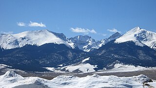
South Park is a grassland flat within the basin formed by the Rocky Mountains' Mosquito and Park Mountain Ranges within central Colorado. This high valley ranges in elevation from approximately 9,000 to 10,000 ft. It encompasses approximately 1,000 square miles around the headwaters of the South Platte River in Park County approximately 60 mi (100 km) southwest of Denver. It is the largest and southernmost of three similarly named high altitude basins in the Front Range of Colorado, the others being North Park and Middle Park. The largest town in the basin is Fairplay, with a population of 681.

U.S. Route 285 is a north–south United States highway, running 846 miles (1,362 km) through the states of Texas, New Mexico and Colorado. The highway's southern terminus is in Sanderson, Texas at an intersection with U.S. Route 90. US 285 has always had an endpoint in Denver, Colorado, although the original US 285 went north from Denver. Today the highway's northern terminus is in Denver, at exit 201 on Interstate 25.

Roaring Fork River is a tributary of the Colorado River, approximately 70 miles (110 km) long, in west central Colorado in the United States. The river drains a populated and economically vital area of the Colorado Western Slope called the Roaring Fork Valley or Roaring Fork Watershed, which includes the resort city of Aspen and the resorts of Aspen/Snowmass.

The Sawatch Range is a high and extensive mountain range in central Colorado which includes eight of the twenty highest peaks in the Rocky Mountains, including Mount Elbert, at 14,440 feet (4,401 m) elevation, the highest peak in the Rockies.
The Wet Mountain Valley is a high elevation mountain valley located in Custer County, in south-central Colorado.

Middle Park is a high basin in the Rocky Mountains of north-central Colorado in the United States. It is located in Grand County, on the southwest slope of Rocky Mountain National Park, approximately 50 miles (80 km) west of Boulder.

Tennessee Pass elevation 10,424 ft (3,177 m) is a high mountain pass in the Rocky Mountains of central Colorado in the United States. The pass was named after Tennessee, the native state of a group of early prospectors.

The Southern Uplands are the southernmost and least populous of mainland Scotland's three major geographic areas. The term is used both to describe the geographical region and to collectively denote the various ranges of hills and mountains within this region.

The Mosquito Range is a high mountain range in the Rocky Mountains of central Colorado in the United States. The peaks of the range form a ridge running north-south for approximately 40 miles (64 km) from southern Summit County on the north end, then along the boundary between Lake and Park counties. The ranges forms a high barrier separating the headwaters of the Arkansas River near Leadville from South Park and the headwaters of the South Platte River near Fairplay. The highest peak in the range is Mount Lincoln at an elevation of 14,286 ft. Other fourteeners in the range are Quandary Peak, Mount Bross (14,172 ft), Mount Democrat (14,148 ft), and Mount Sherman (14,036 ft).

The Elk Mountains are a high, rugged mountain range in the Rocky Mountains of west-central Colorado in the United States. The mountains sit on the western side of the Continental Divide, largely in southern Pitkin and northern Gunnison counties, in the area southwest of Aspen, south of the Roaring Fork River valley, and east of the Crystal River. The range sits west of the Sawatch Range and northeast of the West Elk Mountains. Much of the range is located within the White River National Forest and the Gunnison National Forest, as well as the Maroon Bells-Snowmass Wilderness and Raggeds Wilderness. The Elk Mountains rise nearly 9,000 ft. above the Roaring Fork Valley to the north.

Shrine Pass, elevation 11,094 ft (3,381 m), is a mountain pass in the Sawatch Range of central Colorado.

Trout Creek Pass, elevation 9,487 ft (2,892 m), is a mountain pass located in the Rocky Mountains of south-central Colorado in the United States. The pass sits atop the southern end of the Mosquito Range on the Park-Chaffee county line, between South Park and the headwaters of the Arkansas River to the west. It is traversed jointly by U.S. Highway 24 (US 24) and US 285. It is passable by most motorized vehicles and is closed only during severe winter storms. The approach from the north is mild, while the south side has a moderate 5% grade.

Monarch Pass, elevation 11,312 feet (3,448 m), is a high mountain pass in the Rocky Mountains of south-central Colorado in the United States.

The Collegiate Peaks Wilderness is a 168,000-acre (680 km2) area located in central Colorado between Leadville and Buena Vista to the east and Aspen to the west and Crested Butte to the southwest. Most of the area is in the San Isabel and Gunnison National Forests, with a smaller area in the White River National Forest southeast of Aspen. Most of the area is in northwest Chaffee County with smaller portions in Gunnison, Pitkin, and Lake counties.

Lanfair Valley is located in the Mojave Desert in southeastern California near the Nevada state line. It is bounded on the north by the New York Mountains and Castle Mountains, on the east by the Piute Range, and on the south by the Woods Mountains and Vontrigger Hills. Joshua Trees can be found in most of the valley. Elevation is 4,045 feet.

Granite is an unincorporated community with a U.S. Post Office in Chaffee County, Colorado, United States. The zip code of Granite is 81228. According to the 2010 census, the population is 116.

The Colorado River is a major river of the western United States and northwest Mexico in North America. Its headwaters are in the Rocky Mountains where La Poudre Pass Lake is its source. Located in north central Colorado it flows southwest through the Colorado Plateau country of western Colorado, southeastern Utah and northwestern Arizona where it flows through the Grand Canyon. It turns south near Las Vegas, Nevada, forming the Arizona–Nevada border in Lake Mead and the Arizona–California border a few miles below Davis Dam between Laughlin, Nevada and Needles, California California before entering Mexico in the Colorado Desert. Most of its waters are diverted into the Imperial Valley of Southern California. In Mexico its course forms the boundary between Sonora and Baja California before entering the Gulf of California. This article describes most of the major features along the river.
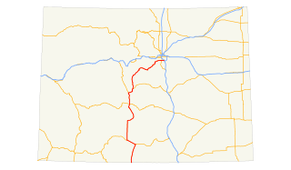
U.S. Route 285 is the section north-south highway in Colorado that starts at the New Mexico state line and ends at I-25, US 87, and SH 30 in Denver.


