Mummy Mountain is a high mountain summit in the Mummy Range of the Rocky Mountains of North America. The 13,430-foot (4,093 m) thirteener is located in the Rocky Mountain National Park Wilderness, 8.5 miles (13.7 km) northwest by north of the Town of Estes Park in Larimer County, Colorado, United States.
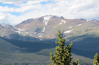
Fairchild Mountain is a high mountain summit in the Mummy Range of the Rocky Mountains of North America. The 13,508-foot (4,117 m) thirteener is located in the Rocky Mountain National Park Wilderness, 9.6 miles (15.5 km) northwest of the Town of Estes Park in Larimer County, Colorado, United States.

Mount Chiquita is a mountain summit in the Mummy Range of the Rocky Mountains of North America. The 13,075-foot (3,985 m) thirteener is located in Rocky Mountain National Park, 9.8 miles (15.7 km) northwest by west of the Town of Estes Park in Larimer County, Colorado, United States.

Greyrock Mountain is a mountain summit in the Laramie Mountains range of the Rocky Mountains of North America. The 7,616-foot (2,321 m) peak is located in Roosevelt National Forest, 1.2 miles (1.9 km) north-northeast of the community Poudre Park in Larimer County, Colorado, United States.

Mount Audubon is a high mountain summit of the Indian Peaks in the northern Front Range of the Rocky Mountains of North America. The 13,229-foot (4,032 m) thirteener is located in the Indian Peaks Wilderness of Roosevelt National Forest, 5.6 miles (9.0 km) west-northwest of the Town of Ward in Boulder County, Colorado, United States. The mountain was named in honor of John James Audubon.
Casco Peak is a high mountain summit in the Sawatch Range of the Rocky Mountains of North America. The 13,915-foot (4,241 m) thirteener is located on the Elbert Massif in San Isabel National Forest, 3.8 miles (6.1 km) east of Independence Pass in Lake County, Colorado, United States.
California Peak is a high mountain summit in the Sangre de Cristo Range of the Rocky Mountains of North America. The 13,855-foot (4,223 m) thirteener is located on the Sierra Blanca Massif, 12.1 miles (19.5 km) north of the Town of Blanca, Colorado, United States, on the drainage divide separating in Rio Grande National Forest and Alamosa County from San Isabel National Forest and Huerfano County.
Dallas Peak is a high mountain summit in the Sneffels Range of the Rocky Mountains of North America. The 13,815-foot (4,211 m) thirteener is located in the Mount Sneffels Wilderness of Uncompahgre National Forest, 3.3 miles (5.3 km) north by west of the Town of Telluride, Colorado, United States, on the drainage divide between Ouray and San Miguel counties.
Emerald Peak is a high mountain summit of the Collegiate Peaks in the Sawatch Range of the Rocky Mountains of North America. The 13,911-foot (4,240 m) thirteener is located in the Collegiate Peaks Wilderness of San Isabel National Forest, 14.7 miles (23.7 km) west-northwest of the Town of Buena Vista in Chaffee County, Colorado, United States.
Fletcher Mountain is a high mountain summit in the Tenmile Range of the Rocky Mountains of North America. The 13,958-foot (4,254 m) thirteener is located in Arapaho National Forest, 8.1 miles (13.0 km) southwest by south of the Town of Breckenridge in Summit County, Colorado, United States.
French Mountain is a high mountain summit in the Sawatch Range of the Rocky Mountains of North America. The 13,966-foot (4,257 m) thirteener is located on the Elbert Massif in San Isabel National Forest, 13.0 miles (20.9 km) southwest by west of the City of Leadville in Lake County, Colorado, United States.
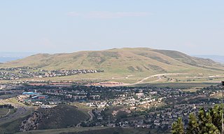
Green Mountain is a mesa on the eastern flank of the Front Range of the Rocky Mountains of North America. The 6,854-foot (2,089 m) mesa summit is located in William Frederick Hayden Park in the City of Lakewood, Colorado, United States, 4.0 miles (6.5 km) west of the municipal center of Lakewood in Jefferson County.

Green Mountain is a mountain summit on the eastern flank of the Front Range of the Rocky Mountains of North America. The 8,148-foot (2,484 m) peak is located in Boulder Mountain Park, 4.2 miles (6.8 km) southwest by south of downtown Boulder in Boulder County, Colorado, United States. The mountain is renowned for the Flatirons rock formations on its eastern flank.
Horseshoe Mountain is a high mountain summit in the Mosquito Range of the Rocky Mountains of North America. The 13,905-foot (4,238 m) thirteener is located 7.1 miles (11.5 km) southeast by east of the City of Leadville, Colorado, United States, on the drainage divide separating San Isabel National Forest and Lake County from Pike National Forest and Park County.
Jagged Mountain is a high mountain summit in the Needle Mountains range of the Rocky Mountains of North America. The 13,830-foot (4,215 m) thirteener is located in the Weminuche Wilderness of San Juan National Forest, 12.2 miles (19.7 km) south-southeast of the Town of Silverton in San Juan County, Colorado, United States.
Jones Mountain is a high mountain summit in the San Juan Mountains range of the Rocky Mountains of North America. The 13,866-foot (4,226 m) thirteener is located 9.6 miles (15.4 km) northeast by east of the Town of Silverton, Colorado, United States, on the Continental Divide between Hinsdale and San Juan counties.
Jupiter Mountain is a high mountain summit in the Needle Mountains range of the Rocky Mountains of North America. The 13,836-foot (4,217 m) thirteener is located in the Weminuche Wilderness of San Juan National Forest, 27.7 miles (44.6 km) northeast by north of the City of Durango in La Plata County, Colorado, United States.
Mount Buckskin is a high mountain summit in the Mosquito Range of the Rocky Mountains of North America. The 13,872-foot (4,228 m) thirteener is located in Pike National Forest, 4.9 miles (7.9 km) west-northwest of the Town of Alma in Park County, Colorado, United States.

Mount Edwards is a high mountain summit in the Rocky Mountains' Front Range of North America. The 13,856-foot (4,223 m) thirteener is located in Arapaho National Forest, 7.6 miles (12.3 km) southwest of the Town of Georgetown, Colorado, United States, on the Continental Divide between Clear Creek and Summit counties.

Mount Guyot is a high mountain summit in the Front Range of the Rocky Mountains of North America. The 13,376-foot (4,077 m) thirteener is located 6.3 miles (10.2 km) east-southeast of the Town of Breckenridge, Colorado, United States, on the Continental Divide separating Pike National Forest and Park County from Arapaho National Forest and Summit County. The mountain was named in honor of Arnold Henry Guyot, a Swiss-American geologist.