
Routt County is a county located in the U.S. state of Colorado. As of the 2020 census, the population was 24,829. The county seat is Steamboat Springs. Routt County comprises the Steamboat Springs, CO Micropolitan Statistical Area.

Grand County is a county located in the U.S. state of Colorado. As of the 2020 census, the population was 15,717. The county seat is Hot Sulphur Springs.

Arapaho National Forest is a National Forest located in north-central Colorado, United States. The region is managed jointly with the Roosevelt National Forest and the Pawnee National Grassland from the United States Forest Service office in Fort Collins, Colorado. It has a wildlife refuge which manages a protection for all birds and mammals. The combined facility of 1,730,603 acres (7,004 km2) is denoted as ARP by the Forest Service. Separately, Arapaho National Forest consists of 723,744 acres (2,929 km2).

The Collegiate Peaks Wilderness is a 168,000-acre (680 km2) area located in central Colorado between Leadville and Buena Vista to the east and Aspen to the west and Crested Butte to the southwest. Most of the area is in the San Isabel and Gunnison National Forests, with a smaller area in the White River National Forest southeast of Aspen. Most of the area is in northwest Chaffee County with smaller portions in Gunnison, Pitkin, and Lake counties.
The Lost Creek Wilderness is a 119,790-acre (485 km2) wilderness area located in central Colorado in Jefferson and Park counties, south of the town of Bailey. The area is situated entirely within the boundaries of the Pike National Forest.
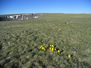
The Powderhorn Wilderness is a 62,050-acre (251.1 km2) wilderness area in Hinsdale and Gunnison counties, Colorado, United States, located 5 miles (8.0 km) northeast of Lake City.

White River National Forest is a National Forest in northwest Colorado. It is named after the White River that passes through its northern section. It is the most visited National Forest in the United States, primarily from users of the twelve ski areas within its boundaries.

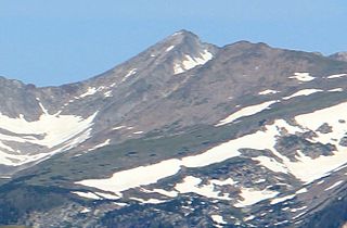
The Mount Zirkel Wilderness is a U.S. Wilderness Area located in Routt National Forest in northwest Colorado. The closest city is Steamboat Springs, Colorado. The wilderness is named after Mount Zirkel, the highest peak in the range at 12,182 feet (3,713 m), which itself is named after German geologist Ferdinand Zirkel.

Flat Tops Wilderness Area is the second largest U.S. Wilderness Area in Colorado. It is 235,214 acres (951.88 km2), with 38,870 acres (157.3 km2) in Routt National Forest and 196,344 acres (794.58 km2) in White River National Forest. It was designated a wilderness area in 1975. Trappers Lake, located in the north of the area, was the lake that inspired Arthur Carhart, a United States Forest Service official, to plead for wilderness preservation.

Medicine Bow–Routt National Forest is the official title to a U.S. Forest Service managed area extending over 2,222,313 acres (8,993.38 km2) in the states of Wyoming and Colorado, United States. What were once three separate areas, Medicine Bow National Forest, Routt National Forest, and Thunder Basin National Grassland were administratively combined in 1995 due to similarity of the resources, proximity to each other and for administrative purposes.
The Platte River Wilderness is primarily located in south central Wyoming, with a small section extending into Colorado in the United States. Located entirely within Medicine Bow - Routt National Forest, the wilderness was created in 1984 to protect the forestlands adjacent to the North Platte River. These forestlands were almost entirely consumed by the Mullen Fire in 2020.

The Rawah Wilderness is administered by the USDA Forest Service. It is located on the Canyon Lakes Ranger District of the Roosevelt National Forest in Colorado, near the Wyoming border, and also in the Routt National Forest to its south. It encompasses 76,394 acres (309.16 km2) and includes 25 named lakes ranging in size from five to 39 acres. There are 85 miles (137 km) of trails in the area and elevation ranges from 8,400 feet (2,600 m) to 13,000 feet (4,000 m). Much of the area is traversed by the Medicine Bow Mountains and the Rawah Range for which it is named. The temperature in the Rawah Wilderness ranges from a low of 5 °F (−15 °C) during the winter and a high of 77 °F (25 °C) during the summer.

The Mount Massive Wilderness is a federally designated wilderness area in the Sawatch Range, located in the U.S. state of Colorado. It is operated jointly by the United States Forest Service and the Fish and Wildlife Service as part of the San Isabel National Forest and the Leadville National Fish Hatchery. It is 30,540 acres (123.6 km2) in size, with 27,980 acres (113.2 km2) in San Isabel National Forest and 2,560 acres (10.4 km2) in Leadville National Fish Hatchery, and it was designated by the US Congress in 1980. The name comes from Mount Massive, the second highest peak in Colorado, located inside the wilderness. Elevations in the wilderness range from 9,700 feet (3,000 m) to 14,421 feet (4,396 m). It is the only federally designated wilderness area within the National Fish Hatchery System.
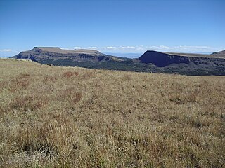
Flat Top Mountain is the highest summit of the Flat Tops in the Rocky Mountains of North America. The prominent 12,361-foot (3,768 m) peak is located in the Flat Tops Wilderness, 19.1 miles (30.7 km) south-southwest of the Town of Oak Creek, Colorado, United States, on the drainage divide between Routt National Forest and White River National Forest. The summit of Flat Top Mountain is the highest point in Garfield County, Colorado.

The Mount Evans Wilderness is a U.S. Wilderness Area in Arapaho National Forest and Pike National Forest about 30 miles (48 km) west of Denver, Colorado. The wilderness area is named after Mount Blue Sky's former name, Mount Evans
The Ptarmigan Peak Wilderness is a U.S. Wilderness Area located north of Dillion, Colorado in the Williams Fork Mountains. The 12,760-acre (51.6 km2) wilderness was established in 1993 in the White River and Routt National Forests.
Lead Mountain is a summit in Grand County, Colorado, in the United States. With an elevation of 12,546 feet (3,824 m), Lead Mountain is the 970th-highest summit in the state of Colorado. Lead Mountain was named in 1879 on account of its lead deposits.

Cannibal Plateau is a summit in Hinsdale County, Colorado in the United States. The broad 12,533-foot (3,820 m) mountain is located in the San Juan Mountains and within the Powderhorn Wilderness, a protected area managed by the Bureau of Land Management Gunnison Field Office and the Gunnison National Forest.
Calf Creek Plateau is a mountain in the northern San Juan Mountains of the Rocky Mountains of North America. The mountain is located in Hinsdale County, and at an elevation of 12,661 feet (3,859 m), it is the high point of the Powderhorn Wilderness.
