Montrose County is a county located in the U.S. state of Colorado. As of the 2020 census, the population was 42,679. The county seat is Montrose, for which the county is named.

Gunnison County is a county located in the U.S. state of Colorado. As of the 2020 census, the population was 16,918. The county seat is Gunnison. The county was named for John W. Gunnison, a United States Army officer and captain in the Army Topographical Engineers, who surveyed for the transcontinental railroad in 1853.

Delta County is a county located in the U.S. state of Colorado. As of the 2020 census, the population was 31,196. The county seat is Delta.

The Collegiate Peaks Wilderness is a 168,000-acre (680 km2) area located in central Colorado between Leadville and Buena Vista to the east and Aspen to the west and Crested Butte to the southwest. Most of the area is in the San Isabel and Gunnison National Forests, with a smaller area in the White River National Forest southeast of Aspen. Most of the area is in northwest Chaffee County with smaller portions in Gunnison, Pitkin, and Lake counties.
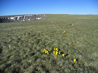
The Powderhorn Wilderness is a 62,050-acre (251.1 km2) wilderness area in Hinsdale and Gunnison counties, Colorado, United States, located 5 miles (8.0 km) northeast of Lake City.

White River National Forest is a National Forest in northwest Colorado. It is named after the White River that passes through its northern section. It is the most visited National Forest in the United States, primarily from users of the twelve ski areas within its boundaries.

The Weminuche Wilderness is a wilderness area in southwest Colorado managed by the United States Forest Service as part of the San Juan National Forest on the west side of the Continental Divide and the Rio Grande National Forest on the east side of the divide. The Weminuche Wilderness was designated by Congress in 1975, and expanded by the Colorado Wilderness Acts of 1980 and 1993. It is located 4 miles (6.4 km) southeast of the town of Silverton, 17 miles (27 km) northeast of Durango, and 8 miles (13 km) west of South Fork. At 499,771 acres (2,022.50 km2), it is the largest wilderness area in the state of Colorado. Elevation in the wilderness ranges from 7,700 feet (2,300 m) along the Animas River to 14,093 feet (4,296 m) at the summit of Windom Peak.

The Gunnison National Forest is a U.S. National Forest covering 1,672,136 acres in Mesa, Gunnison, Hinsdale and Saguache Counties in Western part of the U.S. state of Colorado. It borders the White River National Forest to the north, the Grand Mesa and Uncompahgre National Forests to the west, the San Isabel National Forest to the east and the Rio Grande National Forest to south. It lies in parts of five counties. In descending order of land area within the forest they are Gunnison, Saguache, Hinsdale, Delta, and Montrose counties.

The Fossil Ridge Wilderness is a U.S. Wilderness Area located approximately 16 miles (26 km) northeast of Gunnison, Colorado in the Gunnison National Forest. The 13,992-acre (56.62 km2) wilderness includes Fossil Ridge, a high, exposed ridge of Paleozoic carbonates that contain epeiric sea fossils. Elevations in the wilderness range from 8,880 feet (2,710 m) at Summerville Creek to 13,254 feet (4,040 m) at the summit of Henry Mountain. Elk, deer, mountain goats, and bighorn sheep can be found in the wilderness.

The La Garita Wilderness is a U.S. Wilderness Area located in the La Garita Mountains of southern Colorado. The 129,626-acre (524.58 km2) wilderness established in 1964 in Gunnison and Rio Grande National Forests includes segments of the Colorado Trail and the Continental Divide Trail. At 14,014 feet (4,271 m), San Luis Peak is the highest point in the wilderness area.

The Maroon Bells–Snowmass Wilderness is a U.S. Wilderness Area located in the Elk Mountains of central Colorado. The 181,535-acre (734.65 km2) wilderness was established in 1980 in the Gunnison and White River national forests. Within its boundaries are 100 miles (160 km) of trails, six of Colorado's fourteeners and nine passes over 12,000 feet (3,700 m). The wilderness is named after the two peaks known as the Maroon Bells, and the Snowmass Mountain.
The Raggeds Wilderness is a U.S. Wilderness Area located in the Elk Mountains northwest of Crested Butte, Colorado. The 65,393-acre (264.64 km2) wilderness was established in 1980 in the White River and Gunnison National Forests. Elevations in the wilderness range from 6,840 feet (2,080 m) in Dark Canyon to 13,535 feet (4,125 m) at the summit of Treasure Mountain. Nearly 90 miles (140 km) of trails are within the wilderness.
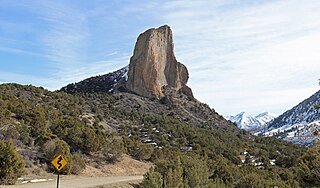
Needle Rock Natural Area is located at the western edge of the West Elk Mountains of Colorado. The surrounding terrain is characterized by laccolithic mountains flanked by precipitous cliffs, extensive talus aprons, forested mesas, canyons, and spacious, well-watered intermontane basins. Needle Rock is an intrusive plug of monzonite porphyry cropping out 3.5 miles (5.6 km) east-northeast of the Town of Crawford in Delta County, Colorado, United States. At an elevation of 7,797 feet (2,377 m), the towering rock spire stands 800 feet (240 m) tall above the floor of the Smith Fork of the Gunnison River valley. The massive rock feature originated in the Oligocene geological epoch when magma intruded between existing sedimentary rocks as the crown of a buried laccolith or possibly the underlying conduit of a laccolith. Subsequent erosion has exposed the prominent rock formation seen in the natural area today.

Treasure Mountain, elevation 13,535 ft (4,125 m), is a summit in the Elk Mountains of western Colorado. The mountain is in the Raggeds Wilderness southeast of Marble. The massif has been the site of marble mining and a legend of lost French gold.
Mount Gunnison is a prominent mountain summit in the West Elk Mountains range of the Rocky Mountains of North America. The 12,725-foot (3,879 m) peak is located in the West Elk Wilderness of Gunnison National Forest, 22.2 miles (35.7 km) west by south of the Town of Crested Butte in Gunnison County, Colorado, United States. The mountain is named in honor of John Williams Gunnison who explored the area.

East Beckwith Mountain is a prominent mountain summit in the West Elk Mountains range of the Rocky Mountains of North America. The 12,441-foot (3,792 m) peak is located in the West Elk Wilderness of Gunnison National Forest, 13.4 miles (21.5 km) west by south of the Town of Crested Butte in Gunnison County, Colorado, United States.

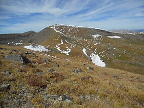
Cannibal Plateau is a summit in Hinsdale County, Colorado in the United States. The broad 12,533-foot (3,820 m) mountain is located in the San Juan Mountains and within the Powderhorn Wilderness, a protected area managed by the Bureau of Land Management Gunnison Field Office and the Gunnison National Forest.

West Beckwith Mountain is a prominent mountain summit in the West Elk Mountains range of the Rocky Mountains of North America. The 12,185-foot (3,714 m) peak is located in the West Elk Wilderness of Gunnison National Forest, about 16.5 miles (26.5 km) southwest of Crested Butte in Gunnison County, Colorado, United States.

The Anthracite Range is a mountain range in the West Elk Mountains, a sub-range of the Rocky Mountains of North America. The range is located in Gunnison County of western Colorado and lies within the West Elk Wilderness of the Gunnison National Forest. The Anthracite Range is one of several prominent laccoliths found in the West Elk Mountains.