
San Miguel County is a county located in the U.S. state of Colorado. As of the 2020 census, the population was 8,072. The county seat is Telluride. The county is named for the San Miguel River.
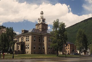
San Juan County is a county located in the U.S. state of Colorado. As of the 2020 census, the population was 705, making it the least populous county in Colorado. The county seat and the only incorporated municipality in the county is Silverton. The county name is the Spanish language name for "Saint John", the name Spanish explorers gave to a river and the mountain range in the area. With a mean elevation of 11,240 feet, San Juan County is the highest county in the United States and also has the two highest elevation houses in the United States; the ‘Bonnie Belle’ above Animas Forks at 11,900’ – 11,950’ elevation and an unnamed house above Picayune Gulch at 12,000’ elevation.
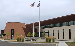
Montezuma County is a county located in the southwest corner of the U.S. state of Colorado. As of the 2020 census, the population was 25,849. The county seat is Cortez.

Dolores County is a county located in the U.S. state of Colorado. As of the 2020 census, the population was 2,326. The county seat is Dove Creek.

Clear Creek County is a county located in the U.S. state of Colorado. As of the 2020 census, the population was 9,397. The county seat is Georgetown.

White River National Forest is a National Forest in northwest Colorado. It is named after the White River that passes through its northern section. It is the most visited National Forest in the United States, primarily from users of the twelve ski areas within its boundaries.

The Uncompahgre Plateau in western Colorado is a distinctive large uplift part of the Colorado Plateau. Uncompahgre is a Ute word that describes the water: "Dirty Water" or "Rocks that make Water Red".

The San Juan Skyway Scenic and Historic Byway is a 236-mile (380 km) All-American Road, National Forest Scenic Byway, and Colorado Scenic and Historic Byway located in Dolores, La Plata, Montezuma, San Juan, and San Miguel counties, Colorado, United States. The byway forms a loop in southwestern Colorado traversing the heart of the San Juan Mountains. The San Juan Skyway reaches its zenith at Red Mountain Pass at elevation 11,018 feet (3,358 m). Mesa Verde National Park was one of the original UNESCO World Heritage Sites. The Silverton Historic District and the Telluride Historic District are National Historic Landmarks.

The Manti–La Sal National Forest covers more than 1.2 million acres (4,900 km2) and is located in the central and southeastern parts of the U.S. state of Utah and the extreme western part of Colorado. The forest is headquartered in Price, with ranger district offices in Price, Ferron, Ephraim, Moab and Monticello. The maximum elevation is Mount Peale in the La Sal Mountains, reaching 12,721 feet (3,877 m) above sea level. The La Sal Mountains are the second highest mountain range in Utah after the Uintas. Parts of the forest are included in the Bears Ears National Monument.

The San Juan National Forest is a U.S. National Forest covering over 1,878,846 acres in western Colorado. The forest occupies land in Archuleta, Conejos, Dolores, Hinsdale, La Plata, Mineral, Montezuma, Rio Grande, San Miguel and San Juan Counties. It borders the Uncompahgre National Forest to the north and the Rio Grande National Forest to the east. The forest covers most of the southern portion of the San Juan Mountains west of the Continental Divide. The forest contains two alpine wilderness areas; the Weminuche and South San Juan, as well as the Piedra Area. The Durango and Silverton Narrow Gauge Railroad passes through the National Forest.

The geography of the U.S. State of Colorado is diverse, encompassing both rugged mountainous terrain, vast plains, desert lands, desert canyons, and mesas. Colorado is a landlocked U.S. state. In 1861, the United States Congress defined the boundaries of the new Territory of Colorado exclusively by lines of latitude and longitude, stretching from 37°N to 41°N latitude, and from 102°02'48"W to 109°02'48"W longitude. Starting in 1868, official surveys demarcated the boundaries, deviating from the parallels and meridians in several places. Later surveys attempted to correct some of these mistakes but in 1925 the U.S. Supreme Court affirmed that the earlier demarcation was the official boundary. The borders of Colorado are now officially defined by 697 boundary markers connected by straight boundary lines. Colorado, Wyoming, and Utah are the only states that have their borders defined solely by straight boundary lines with no natural features. The southwest corner of Colorado is the Four Corners Monument at 36°59'56"N, 109°2'43"W. This is the only place in the United States where four states meet: Colorado, New Mexico, Arizona, and Utah.

The Curecanti Needle is a 700-ft granite spire located on the Gunnison River in western Colorado. A notable landmark to generations of natives and pioneers, the Needle is located on the southern bank of Morrow Point Reservoir, an impoundment of the Gunnison river between Gunnison and Montrose, Colorado. Used for many years as an advertising symbol for the Denver and Rio Grande Western Railroad, whose narrow-gauge railway famously ran along the northern bank of the river and passed near the Needle, the spire is today part of the Curecanti National Recreation Area, a National Park Service facility that encompasses three impoundments of the Gunnison river, including Morrow Point Reservoir.

Beaver Creek Massacre Site, located about 16 miles (26 km) Dolores, Colorado, occurred on June 19, 1885 between Ute Mountain Utes and white cattlemen over land use and Native American policies established for Native Americans. The last conflict of its kind in Colorado, it followed the Meeker Massacre and Sand Creek Massacre. Six or eleven Ute Mountain Ute Tribe people were killed. Two or three days later, a white man and his family were attacked in Montezuma County. Mr. Genthner was killed and his wife was wounded. The Beaver Creek Massacre site is located along a dirt forest road in the Dolores Ranger District of the San Juan National Forest. It was added to the National Register of Historic Places on October 2, 1986.

The Trail of the Ancients is a collection of National Scenic Byways located in the U.S. Four Corners states of Utah, Colorado, New Mexico, and Arizona. These byways comprise:

Grays Peak National Recreation Trail or Grays Peak Trail lies along the Continental Divide of the Americas, part of the Rocky Mountains in the U.S. state of Colorado. It is located in the White River National Forest, Summit County. Grays Peak Trail is south of Interstate 70, east of Keystone Resort and near Montezuma. Grays Peak is adjacent to Torreys Peak. The Grays Peak Trail begins 3 miles above Interstate 70, at 11,200 feet. The summit of Grays Peak is 3.7 miles from the trailhead. Torreys Peak is 4.15 miles from the trailhead, across a saddle from Grays Peak. Grays Peak Trail ascends south through the wetland willows of Stevens Gulch. The trail passes between Stevens Mine on a lower slope of McClellan Mountain, 13,587 feet, forming the eastern wall of the valley, and Sterling Silver Group Mine beside the trail to the right on Kelso Mountain, 13,164 feet. The trail climbs 900 feet during the first 1.7 miles to a National Recreation Trail sign indicating that the summit is two miles farther.
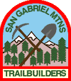
The San Gabriel Mountains Trailbuilders (SGMTBs) is a 501(c)(3) non-profit volunteer organization which performs hiking and nature trail building and maintenance within the Los Angeles Gateway District of the United States Forest Service which maintains the Angeles National Forest within the San Gabriel Mountains.

Laguña Creek also formerly also known as Tyende Creek, is a stream in the Navajo and Apache Counties of Arizona. Laguña Creek has its source at 36°41′15″N110°30′36″W, at the confluence of Long Canyon and Dowozhiebito Canyon at an elevation of 6,325 feet at the head of Tsegi Canyon. Its mouth is in the Chinle Valley at its confluence with Chinle Wash which together forms Chinle Creek, at an elevation of 4,774 feet. Chinle Creek is a tributary of San Juan River which is in turn a tributary of the Colorado River.

Chinle Creek is a tributary stream of the San Juan River in Apache County, Arizona and San Juan County, Utah. Its source is at 36°53′40″N109°44′37″W, the confluence of Laguña Creek and the Chinle Wash arroyo. Its name is derived from the Navajo word ch'inili meaning 'where the waters came out. Its sources is in Canyon de Chelly National Monument where Canyon de Chelly and Canyon del Muerto have their confluence at an elevation of 5,616 feet at 36°08′35″N109°29′17″W. It then trends northwest to its confluence with Laguña Creek where it forms Chinle Creek, 7 miles northeast of Dennehotso, Arizona at an elevation of 4,774 feet.

The Hermosa Creek Wilderness is a 37,236-acre (15,069 ha) U.S. Wilderness Area in La Plata County, Colorado. It s located in the San Juan National Forest 12 miles (19 km) north of Durango. It was established by the Hermosa Creek Protection Act of 2014, which also created the adjacent Hermosa Creek Special Management Area, which shares its eastern border, Hermosa Creek. Elevation in the wilderness ranges from 7,500 feet (2,300 m) along Hermosa Creek to 12,338 feet (3,761 m) at the high point of Indian Trail Ridge.