Dacono, Colorado

Last updated

Dacono, Colorado
DaconoCityHall.jpg
The Dacono City Hall
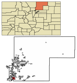
Weld County Colorado Incorporated and Unincorporated areas Dacono Highlighted 0819080.svg
Location of the City of Dacono in Weld County, Colorado
Usa edcp location map.svg
Red pog.svg
Dacono
Location of the City of Dacono in the United States
Coordinates: 40°03′49″N104°56′48″W / 40.063521°N 104.946804°W / 40.063521; -104.946804 [2]
Country Flag of the United States.svg  United States
State Flag of Colorado.svg  Colorado
County Weld County [1]
Settled1901
Incorporated September 23, 1908 [3]
Government
  Type Home rule municipality [1]
Area
[4]
  Total8.796 sq mi (22.782 km2)
  Land8.790 sq mi (22.766 km2)
  Water0.006 sq mi (0.016 km2)
Elevation
[5]
5,030 ft (1,533 m)
Population
 (2020) [4]
  Total6,297
  Density716/sq mi (276/km2)
   Metro
328,981 (156th)
   CSA
3,623,560 (17th)
   Front Range
5,055,344
Time zone UTC−07:00 (MST)
  Summer (DST) UTC−06:00 (MDT)
ZIP code [6]
80514
Area code 303
FIPS code 08-19080
GNIS feature ID 0180837
Website www.cityofdacono.com

Dacono is a home rule municipality located in southwestern Weld County, Colorado, United States. [1] The city population was 6,297 at the 2020 United States Census, an increase of +51.66% since the 2010 United States Census. [4] Dacono is a part of the Greeley, CO Metropolitan Statistical Area and the Front Range Urban Corridor.

Contents

History

The city name's is an amalgamation of the names of Daisy Baum, Cora Van Vorhies, and Nora Brooks, local coal mine operators. [7] Dacono was first settled in 1901, and early settlers moved there to work in the coal mines. [8] The city was incorporated in 1908. [9]

Geography

Dacono is located at 40°4′33″N104°56′43″W / 40.07583°N 104.94528°W / 40.07583; -104.94528 (40.075772, -104.945353). [10]

At the 2020 United States Census, the town had a total area of 5,630 acres (22.782 km2) including 4 acres (0.016 km2) of water. [4]

Demographics

Historical population
CensusPop.Note
1910 180
1920 172−4.4%
1930 27559.9%
1940 2967.6%
1950 258−12.8%
1960 30217.1%
1970 36019.2%
1980 2,321544.7%
1990 2,228−4.0%
2000 3,01535.3%
2010 4,15237.7%
2020 6,29751.7%
U.S. Decennial Census

As of the census [11] of 2000, there were 3,015 people, 1,087 households, and 756 families residing in the city. The population density was 1,103.0 inhabitants per square mile (425.9/km2). There were 1,136 housing units at an average density of 415.6 per square mile (160.5/km2). The racial makeup of the city was 77.05% White, 0.43% African American, 0.96% Native American, 1.00% Asian, 17.98% from other races, and 2.59% from two or more races. Hispanic or Latino people of any race were 32.04% of the population.

There were 1,087 households, out of which 34.6% had children under the age of 18 living with them, 55.3% were married couples living together, 9.3% had a female householder with no husband present, and 30.4% were non-families. 23.6% of all households were made up of individuals, and 7.6% had someone living alone who was 65 years of age or older. The average household size was 2.77 and the average family size was 3.32.[ citation needed ]

In the city, the population was spread out, with 29.2% under the age of 18, 7.9% from 18 to 24, 32.4% from 25 to 44, 21.2% from 45 to 64, and 9.3% who were 65 years of age or older. The median age was 33 years. For every 100 females, there were 100.2 males. For every 100 females age 18 and over, there were 99.3 males.

The median income for a household in the city was $38,854, and the median income for a family was $42,659. Males had a median income of $29,899 versus $25,000 for females. The per capita income for the city was $15,368. About 3.6% of families and 6.0% of the population were below the poverty line, including 6.5% of those under age 18 and 6.4% of those age 65 or over.

Points of interest

Dacono is home to the Colorado National Speedway.

See also

Related Research Articles

<span class="mw-page-title-main">Weld County, Colorado</span> County in Colorado, United States

Weld County is a county located in the U.S. state of Colorado. As of the 2020 census, the population was 328,981. The county seat is Greeley.

<span class="mw-page-title-main">Gilpin County, Colorado</span> County in Colorado, United States

Gilpin County is a county located in the U.S. state of Colorado, smallest in land area behind only the City and County of Broomfield. As of the 2020 census, the population was 5,808. The county seat is Central City. The county was formed in 1861, while Colorado was still a territory, and was named after Colonel William Gilpin, the first territorial governor.

<span class="mw-page-title-main">Brighton, Colorado</span> City in Colorado, United States

Brighton is a home rule municipality city located in Adams and Weld counties, Colorado, United States. Brighton is the county seat of Adams County and a part of the Denver–Aurora–Lakewood, CO Metropolitan Statistical Area and the Front Range Urban Corridor. The city population was 40,083 at the 2020 United States Census with 39,718 residing in Adams County and 365 residing in Weld County.

<span class="mw-page-title-main">Federal Heights, Colorado</span> City in Colorado, United States

The City of Federal Heights is a home rule municipality located in western Adams County, Colorado, United States. The city population was 14,382 at the 2020 United States Census, a +25.42% increase since the 2010 United States Census. Federal Heights is a part of the Denver–Aurora–Lakewood, CO Metropolitan Statistical Area and the Front Range Urban Corridor. The current Mayor is Linda S. Montoya, who was elected to a four-year term in 2019.

<span class="mw-page-title-main">Cherry Hills Village, Colorado</span> City in Colorado, United States

The City of Cherry Hills Village is a home rule municipality located in Arapahoe County, Colorado, United States. The city population was 6,442 at the 2020 United States Census. Cherry Hills Village is a part of the Denver–Aurora–Lakewood, CO Metropolitan Statistical Area and the Front Range Urban Corridor.

<span class="mw-page-title-main">Deer Trail, Colorado</span> Town in Colorado, United States

The Town of Deer Trail is a Statutory Town located in eastern Arapahoe County, Colorado, United States. The town population was 1,068 at the 2020 United States Census, a +95.60% increase since the 2010 United States Census. Deer Trail is a part of the Denver–Aurora–Lakewood, CO Metropolitan Statistical Area and the Front Range Urban Corridor. The town is situated along Interstate 70, approximately 55 miles (89 km) east of Denver.

<span class="mw-page-title-main">Foxfield, Colorado</span> Town in Colorado, United States

The Town of Foxfield is a statutory town located in Arapahoe County, Colorado, United States. The town population was 754 at the 2020 United States Census. Foxfield is a part of the Denver–Aurora–Lakewood, CO Metropolitan Statistical Area and the Front Range Urban Corridor. The town is bordered by the cities of Aurora and Centennial.

<span class="mw-page-title-main">Wiggins, Colorado</span> Town in Colorado, United States

Wiggins is a statutory town in Morgan County, Colorado, United States. The population was 1,401 as of the 2020 census, up from 893 at the 2010 census.

<span class="mw-page-title-main">Rye, Colorado</span> Town in Colorado, United States

Rye is a Statutory Town in Pueblo County, Colorado, United States. The population was 206 at the 2020 census.

<span class="mw-page-title-main">Ault, Colorado</span> Town in Colorado, United States

Ault is a statutory town located in Weld County, Colorado, United States. The town population was 1,887 at the 2020 United States Census, a +24.23% increase since the 2010 United States Census. Ault is a part of the Greeley, CO Metropolitan Statistical Area and the Front Range Urban Corridor.

<span class="mw-page-title-main">Eaton, Colorado</span> Town in Colorado, United States

The Town of Eaton is a Statutory Town located in Weld County, Colorado, United States. The town population was 5,802 at the 2020 United States Census, a +32.92% increase since the 2010 United States Census. Eaton is a part of the Greeley, CO Metropolitan Statistical Area and the Front Range Urban Corridor.

<span class="mw-page-title-main">Evans, Colorado</span> City in Colorado, United States

The City of Evans is a home rule municipality located in Weld County, Colorado, United States. The city population was 22,165 at the 2020 United States Census, a 19.57% increase since the 2010 United States Census. Evans is a part of the Greeley, CO Metropolitan Statistical Area and the Front Range Urban Corridor.

<span class="mw-page-title-main">Firestone, Colorado</span> Town in Colorado, United States

The Town of Firestone is a Statutory Town in southwestern Weld County, Colorado, United States. The town population was 16,381 at the 2020 United States Census, a 61.44% increase since the 2010 United States Census. Firestone is a part of the Greeley, CO Metropolitan Statistical Area and the Front Range Urban Corridor.

<span class="mw-page-title-main">Fort Lupton, Colorado</span> City in Colorado, United States

The City of Fort Lupton is a Statutory City located in southern Weld County, Colorado, United States. The town population was 7,955 at the 2020 United States Census. Fort Lupton is a part of the Greeley, Colorado Metropolitan Statistical Area and the Front Range Urban Corridor.

<span class="mw-page-title-main">Frederick, Colorado</span> Town in Colorado, United States

The Town of Frederick is a Statutory Town located in Weld County, Colorado, United States. The town population was 14,513 at the 2020 United States Census, a +67.22% increase since the 2010 United States Census. Frederick is a part of the Greeley, CO Metropolitan Statistical Area and the Front Range Urban Corridor.

<span class="mw-page-title-main">Gilcrest, Colorado</span> Town in Colorado, United States

The Town of Gilcrest is a Statutory Town located in Weld County, Colorado, United States. The town population was 1,029 at the 2020 United States Census. Gilcrest is a part of the Greeley, CO Metropolitan Statistical Area and the Front Range Urban Corridor.

<span class="mw-page-title-main">Grover, Colorado</span> Town in Colorado, United States

The Town of Grover is a Statutory Town located in Weld County, Colorado, United States. The town population was 157 at the 2020 United States Census, a 14.60% increase since the 2010 United States Census. Grover is a part of the Greeley, CO Metropolitan Statistical Area and the Front Range Urban Corridor.

<span class="mw-page-title-main">Mead, Colorado</span> Town in Colorado, United States

The Town of Mead is a Statutory Town in Weld County, Colorado, United States. The town population was 4,781 at the 2020 United States Census.

<span class="mw-page-title-main">Platteville, Colorado</span> Town in Colorado, United States

Platteville is a Statutory Town in Weld County, Colorado, United States. The population was 2,955 at the 2020 census. It is adjacent to Fort Vasquez on U.S. Highway 85.

<span class="mw-page-title-main">South Greeley, Wyoming</span> Census-designated place in Wyoming, United States

South Greeley is a census-designated place (CDP) in Laramie County, Wyoming, United States. It is part of the Cheyenne, Wyoming Metropolitan Statistical Area. The population was 4,733 at the 2020 census. The population was 4,217 at the 2010 census.

References

  1. 1 2 3 4 "Active Colorado Municipalities". Colorado Department of Local Affairs . Retrieved October 15, 2021.
  2. "2014 U.S. Gazetteer Files: Places". United States Census Bureau. July 1, 2014. Retrieved January 5, 2015.
  3. "Colorado Municipal Incorporations". State of Colorado, Department of Personnel & Administration, Colorado State Archives. December 1, 2004. Retrieved September 2, 2007.
  4. 1 2 3 4 "Decennial Census P.L. 94-171 Redistricting Data". United States Census Bureau, United States Department of Commerce. August 12, 2021. Retrieved September 7, 2021.
  5. "US Board on Geographic Names". United States Geological Survey. October 25, 2007. Retrieved January 31, 2008.
  6. "ZIP Code Lookup". United States Postal Service. Archived from the original (JavaScript/HTML) on November 4, 2010. Retrieved September 6, 2007.
  7. Dawson, John Frank. Place names in Colorado: why 700 communities were so named, 150 of Spanish or Indian origin. Denver, CO: The J. Frank Dawson Publishing Co. p. 16.
  8. "Dacono History". City of Dacono Colorado. Retrieved September 7, 2012.
  9. "Dacono, Colorado". City-Data.com. Retrieved September 7, 2012.
  10. "US Gazetteer files: 2010, 2000, and 1990". United States Census Bureau. February 12, 2011. Retrieved April 23, 2011.
  11. "U.S. Census website". United States Census Bureau . Retrieved January 31, 2008.