Kersey, Colorado

Last updated

Town of Kersey, Colorado
Kersey, CO.jpg
Kersey, February 2018
Weld County Colorado Incorporated and Unincorporated areas Kersey Highlighted 0840515.svg
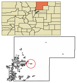
Location of Kersey in Weld County, Colorado.
Coordinates: 40°23′10″N104°33′41″W / 40.38611°N 104.56139°W / 40.38611; -104.56139
Country Flag of the United States (23px).png  United States
State Flag of Colorado.svg  Colorado
County [1] Weld
Incorporated (town) December 3, 1908 [2]
Government
  Type Statutory Town [1]
Area
[3]
  Total2.03 sq mi (5.25 km2)
  Land2.02 sq mi (5.24 km2)
  Water0.01 sq mi (0.01 km2)
Elevation
[4]
4,619 ft (1,408 m)
Population
 (2020) [5]
  Total1,495
  Density740/sq mi (280/km2)
Time zone UTC-7 (Mountain (MST))
  Summer (DST) UTC-6 (MDT)
ZIP code [6]
80644
Area code 970
FIPS code 08-40515
GNIS feature ID 0204695
Website www.kerseygov.com

The Town of Kersey is a Statutory Town in Weld County, Colorado, United States. The population was 1,495 at the 2020 United States Census. [5]

Contents

History

Elbridge Gerry established a trading post called Fort Gerry on the South Platte River near the present-day town of Kersey, Colorado in the 1830s. He had two Native American wives who helped him run the post. In 1840, Gerry abandoned the site and built a post on the south bank of the river. [7] [8] Gerry is said to be the first white man to settle in what is now Weld County. [9]

A post office called Kersey has been in operation since 1894. [10] A railroad official gave Kersey the maiden name of his mother. [11]

Geography

Kersey is located at 40°23′10″N104°33′41″W / 40.38611°N 104.56139°W / 40.38611; -104.56139 (40.386060, -104.561453). [12]

According to the United States Census Bureau, the town has a total area of 1.0 square mile (2.6 km2), all of it land.

Demographics

Historical population
CensusPop.Note
1910 304
1920 3194.9%
1930 307−3.8%
1940 268−12.7%
1950 30413.4%
1960 37824.3%
1970 47425.4%
1980 91392.6%
1990 863−5.5%
2000 1,40662.9%
2010 1,4543.4%
2020 1,4952.8%

See also

Related Research Articles

<span class="mw-page-title-main">Northglenn, Colorado</span> City in Colorado, United States

The City of Northglenn is a home rule municipality located in Adams and Weld counties, Colorado, United States. Northglenn is a part of the Denver–Aurora–Lakewood, CO Metropolitan Statistical Area. As of the 2020 census the city's population was 38,131. It was built as a master planned community in 1959 by Jordon Perlmutter.

<span class="mw-page-title-main">Sugar City, Colorado</span> Town in Colorado, United States

Sugar City is a Statutory Town in Crowley County, Colorado, United States. The population was 259 at the 2020 census.

<span class="mw-page-title-main">Paoli, Colorado</span> Town in Phillips County, Colorado, United States

Paoli is a Statutory Town in Phillips County, Colorado, United States. The population was 51 according to the 2020 census.

<span class="mw-page-title-main">Dacono, Colorado</span> City in Colorado, United States

Dacono is a home rule municipality located in southwestern Weld County, Colorado, United States. The city population was 6,297 at the 2020 United States Census, an increase of +51.66% since the 2010 United States Census. Dacono is a part of the Greeley, CO Metropolitan Statistical Area and the Front Range Urban Corridor.

<span class="mw-page-title-main">Eaton, Colorado</span> Town in Colorado, United States

The Town of Eaton is a Statutory Town located in Weld County, Colorado, United States. The town population was 5,802 at the 2020 United States Census, a +32.92% increase since the 2010 United States Census. Eaton is a part of the Greeley, CO Metropolitan Statistical Area and the Front Range Urban Corridor.

<span class="mw-page-title-main">Evans, Colorado</span> City in Colorado, United States

The City of Evans is a home rule municipality located in Weld County, Colorado, United States. The city population was 22,165 at the 2020 United States Census, a 19.57% increase since the 2010 United States Census. Evans is a part of the Greeley, CO Metropolitan Statistical Area and the Front Range Urban Corridor.

<span class="mw-page-title-main">Firestone, Colorado</span> Town in Colorado, United States

The Town of Firestone is a Statutory Town in southwestern Weld County, Colorado, United States. The town population was 16,381 at the 2020 United States Census, a 61.44% increase since the 2010 United States Census. Firestone is a part of the Greeley, CO Metropolitan Statistical Area and the Front Range Urban Corridor.

<span class="mw-page-title-main">Gilcrest, Colorado</span> Town in Colorado, United States

The Town of Gilcrest is a Statutory Town located in Weld County, Colorado, United States. The town population was 1,029 at the 2020 United States Census. Gilcrest is a part of the Greeley, CO Metropolitan Statistical Area and the Front Range Urban Corridor.

<span class="mw-page-title-main">Hudson, Colorado</span> Town in Colorado, United States

The Town of Hudson is a home rule municipality in Weld County, Colorado, United States. The population was 1,651 at the 2020 census.

<span class="mw-page-title-main">Keenesburg, Colorado</span> Town in Colorado, United States

The Town of Keenesburg is a Statutory Town in Weld County, Colorado, United States. The population was 1,250 at the 2020 United States Census. It is home to The Wild Animal Sanctuary.

<span class="mw-page-title-main">LaSalle, Colorado</span> Town in Colorado, United States

The Town of LaSalle is a Statutory Town in Weld County, Colorado, United States. The town population was 2,359 at the 2020 United States Census.

<span class="mw-page-title-main">Lochbuie, Colorado</span> Town in Colorado, United States

The Town of Lochbuie is a statutory town located in Weld and Adams counties in the U.S. state of Colorado. The town population was 8,088 at the 2020 United States Census.

<span class="mw-page-title-main">Mead, Colorado</span> Town in Colorado, United States

The Town of Mead is a Statutory Town in Weld County, Colorado, United States. The town population was 4,781 at the 2020 United States Census.

<span class="mw-page-title-main">Milliken, Colorado</span> Town in Colorado, United States

Milliken is a statutory town in Weld County, Colorado, United States. The town population was 8,386 at the 2020 United States Census.

<span class="mw-page-title-main">Nunn, Colorado</span> Town in Colorado, United States

Nunn is a Statutory Town in Weld County, Colorado, United States. The population was 504 at the 2020 census.

<span class="mw-page-title-main">Pierce, Colorado</span> Town in Colorado, United States

Pierce is a Statutory Town in Weld County, Colorado, United States. The population was 1,097 at the 2020 census. The town is a rural agricultural community located on the Colorado Eastern Plains along U.S. Highway 85 north of Greeley.

<span class="mw-page-title-main">Platteville, Colorado</span> Town in Colorado, United States

Platteville is a Statutory Town in Weld County, Colorado, United States. The population was 2,955 at the 2020 census. It is adjacent to Fort Vasquez on U.S. Highway 85.

<span class="mw-page-title-main">Raymer, Colorado</span> Town in Colorado, United States

The Town of Raymer is a Statutory Town located in Weld County, Colorado, United States. The population was 110 at the U.S. Census 2020.

<span class="mw-page-title-main">Severance, Colorado</span> Town in the United States

Severance is a Statutory Town in Weld County, Colorado, United States. The population was 7,683 at the 2020 census. The town is located on the Colorado Eastern Plains, northwest of Greeley, a crossroads of county roads.

<span class="mw-page-title-main">Wray, Colorado</span> City in Colorado, United States

Wray is the home rule municipality that is the county seat of Yuma County, Colorado, United States. Located in the Colorado Plains, the city is 170 miles east of Denver, 9 miles west of the Nebraska state line, and 25 miles northwest of the Kansas state line. The population was 2,358 at the 2020 United States census.

References

  1. 1 2 "Active Colorado Municipalities". State of Colorado, Department of Local Affairs. Archived from the original on December 12, 2009. Retrieved September 1, 2007.
  2. "Colorado Municipal Incorporations". State of Colorado, Department of Personnel & Administration, Colorado State Archives. December 1, 2004. Retrieved September 2, 2007.
  3. "2019 U.S. Gazetteer Files". United States Census Bureau. Retrieved July 1, 2020.
  4. "US Board on Geographic Names". United States Geological Survey. October 25, 2007. Retrieved January 31, 2008.
  5. 1 2 United States Census Bureau. "Kersey town, Colorado" . Retrieved April 19, 2023.
  6. "ZIP Code Lookup". United States Postal Service. Archived from the original (JavaScript/HTML) on November 4, 2010. Retrieved October 18, 2007.
  7. Phil Payette; Pete Payette. "Colorado forts - Fort Huerfano". American Forts Network. Retrieved June 6, 2018.
  8. Pick-Sloan Missouri Basin Program, Narrows Unit: Environmental Impact Statement. 1976. p. 17.
  9. Sarah Arnusch (2014). Evans. Arcadia Publishing. pp. 14–. ISBN   978-1-4671-3121-6.
  10. "Post offices". Jim Forte Postal History. Retrieved June 29, 2016.
  11. Dawson, John Frank. Place names in Colorado: why 700 communities were so named, 150 of Spanish or Indian origin. Denver, CO: The J. Frank Dawson Publishing Co. p. 29.
  12. "US Gazetteer files: 2010, 2000, and 1990". United States Census Bureau. February 12, 2011. Retrieved April 23, 2011.