Fort Lupton (Colorado)

Last updated
Fort Lupton
Trading post and fort
Sketch of Fort Lupton 1913.jpg
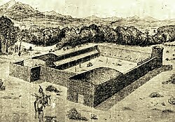
Sketch of Fort Lupton, 1913, Dr. K.L. Clock. Developed from examinations of the ruins of the fort and interviews with pioneers. Given to the Colorado Historical Society.
Nickname: 
Fort Lancaster
USA Colorado location map.svg
Red pog.svg
Fort Lupton
Site of reconstructed fort, a few yards from the original site
Coordinates: 40°5′54.3″N104°49′9.68″W / 40.098417°N 104.8193556°W / 40.098417; -104.8193556
CountryUnited States
State Colorado
County Weld
City Fort Lupton
Founded byLawrence Lupton

Fort Lupton, located in the city of the same name, [1] was a trading post from 1836 [2] [3] or 1837 to 1844. [4] After operating as a stage coach station and used as a house, the building fell into disrepair and crumbled to all but a portion of one wall by the early 20th century. The trading post has been reconstructed yards away from its original site and is now part of the South Platte Historical Park in northwestern Fort Lupton, Colorado.

Contents

History

First called Fort Lancaster, [3] [4] it was established by Lancaster Lupton, a former lieutenant, dragoon soldier, [2] and West Point graduate. He first visited the area during the Dodge-Leavenworth Expedition with Col. Henry Dodge. He resigned and returned to the South Platte area to build the trading post with the assistance of Mexican and Native American men. It had 15-foot walls of adobe brick and an enclosed area of about 125 feet by 150 feet. For defense, it had a tower overlooking the countryside and holes on the second floor to shoot rifles at hostile people. The fort contained a series of small rooms used for living quarters and trading, a blacksmith shop, and a commissary. [3]

Fort Lupton was one of several trading posts established along a 13-mile stretch of the South Platte River in the late 1830s. The others were Fort Jackson, Fort Vasquez, [5] and Fort Saint Vrain. [6] Trappers and Native Americans traded at Fort Lupton, which was located on the Trapper's Trail between Laramie, Wyoming and Santa Fe. They traded buffalo hides and beaver pelts for goods, such as food staples, cloth, blankets, pots, pans, knives, and guns. [2] [3] Supplies and livestock were also sold to settlers. [3] Traders could made enough money in one summer to purchase a farm in the eastern portion of the United States. There may have been as many as 40 people living at the trading post, many of whom were Spanish-speaking employees, during its operation. [3] [2] Rufus Sage, Kit Carson and John C. Frémont visited Fort Lupton. [3] In the early 1840s, the fur trade collapsed and the trading posts closed. [5]

Aftermath and reconstruction

A portion of the wall from the former Fort Lupton trading post,1913 Portion of Fort Lupton wall 1913.jpg
A portion of the wall from the former Fort Lupton trading post,1913

After the trading post closed, it was unused until 1859 when it was used as a stage station during the gold rush. It was then used by a family named Ewing as a house for a number of years. It had deteriorated by 1900 and only a wall remained by the 1920s. [3] In 1926, the Territorial Daughters of Colorado installed a wrought iron fence and historical marker at the site of the former trading post. The land was repurposed again when an oil rig was established there. Later, the land was acquired by the South Platte Historical Society. The original site of the fort is an archaeological site. [7]

In 2009, [3] the fort was reconstructed a few yards from the site of the trading post using some of the original adobe bricks. [4] [2] South Platte Valley Historical Park was established by the South Platte Valley Historical Society northwest of the city of Fort Lupton. It includes a reconstruction of the adobe trading post, Fort Lupton, and is a historical park about area settlement. [2] [8]

See also

Related Research Articles

<span class="mw-page-title-main">Fort Lupton, Colorado</span> City in Colorado, United States

The City of Fort Lupton is a Statutory City located in southern Weld County, Colorado, United States. The town population was 7,955 at the 2020 United States Census. Fort Lupton is a part of the Greeley, Colorado Metropolitan Statistical Area and the Front Range Urban Corridor.

<span class="mw-page-title-main">North Platte River</span> River in the Western United States

The North Platte River is a major tributary of the Platte River and is approximately 716 miles (1,152 km) long, counting its many curves. In a straight line, it travels about 550 miles (890 km), along its course through the U.S. states of Colorado, Wyoming, and Nebraska.

<span class="mw-page-title-main">Fort Laramie National Historic Site</span> National Historic Site of the United States in Wyoming

Fort Laramie was a significant 19th-century trading post, diplomatic site, and military installation located at the confluence of the Laramie and the North Platte Rivers. They joined in the upper Platte River Valley in the eastern part of the present-day U.S. state of Wyoming. The fort was founded as a private trading-post in the 1830s to service the overland fur trade; in 1849, it was purchased by the United States Army. The site was located east of the long climb leading to the best and lowest crossing-point over the Rocky Mountains at South Pass and became a popular stopping-point for migrants on the Oregon Trail. Along with Bent's Fort on the Arkansas River, the trading post and its supporting industries and businesses were the most significant economic hub of commerce in the region.

<span class="mw-page-title-main">Fort Kearny</span> United States historic place

Fort Kearny was a historic outpost of the United States Army founded in 1848 in the western U.S. during the middle and late 19th century. The fort was named after Col. and later General Stephen Watts Kearny. The outpost was located along the Oregon Trail near Kearney, Nebraska. The town of Kearney took its name from the fort. The "e" was added to Kearny by postmen who consistently misspelled the town name. A portion of the original site is preserved as Fort Kearny State Historical Park by the Nebraska Game and Parks Commission.

<span class="mw-page-title-main">Bent's Old Fort National Historic Site</span> National Historic Site of the United States

Bent's Old Fort is an 1833 fort located in Otero County in southeastern Colorado, United States. A company owned by Charles Bent and William Bent and Ceran St. Vrain built the fort to trade with Southern Cheyenne and Arapaho Plains Indians and trappers for buffalo robes. For much of its 16-year history, the fort was the only major white American permanent settlement on the Santa Fe Trail between Missouri and the Mexican settlements. It was destroyed in 1849.

<span class="mw-page-title-main">Ceran St. Vrain</span> French–American fur trader (1802–1870)

Ceran St. Vrain, born Ceran de Hault de Lassus de Saint-Vrain, was the son of a French aristocrat who emigrated to the Spanish Louisiana in the late 18th century; his mother was from St. Louis, where he was born. To gain the ability to trade, in 1831 he became a naturalized Mexican citizen in what is now the state of New Mexico. He formed a partnership with American traders William, George and Charles Bent; together they established the trading post of Bent's Fort. It was the only privately held fort in the West.

Lancaster Platt Lupton was the son of William Lupton, Jr.. He attended West Point, graduating with the class of 1829. In 1835, Lieutenant Lupton was a member of Colonel Henry Dodge's United States Regiment of Dragoons when they passed through the South Platte Valley in what would become the state of Colorado. Lupton saw the potential for a successful trading post on the banks of the South Platte River. He resigned his commission and returned the next year to build Fort Lancaster, later called Fort Lupton.

<span class="mw-page-title-main">Fort Vasquez</span> United States historic place

Fort Vasquez is a former fur trading post 35 miles (56 km) northeast of Denver, Colorado, United States, founded by Louis Vasquez and Andrew Sublette in 1835. Restored by the Works Progress Administration in the 1930s, it now lies in a rather incongruous position as U.S. Route 85 splits to run either side of the building. History Colorado took possession of the property in 1958 and runs it as a museum to display exhibits of the fur-trade era.

<span class="mw-page-title-main">Fort Saint Vrain</span> Trading post and fort in Colorado, United States

Fort Saint Vrain was an 1837 fur trading post built by the Bent, St. Vrain Company, and located at the confluence of Saint Vrain Creek and the South Platte River, about 20 miles (32 km) east of the Rocky Mountains in the unorganized territory of the United States, in present-day Weld County, Colorado. A historical marker notes the place where Old Fort St. Vrain once stood, today at the end of Weld County Road 40, located about seven miles north of Fort Vasquez, Colorado. Among those who helped to establish the fort was Ceran St. Vrain, after whom it was named.

<span class="mw-page-title-main">Trapper's Trail</span> Historical trail or road

The Trapper's Trail or Trappers' Trail is a north-south path along the eastern base of the Rocky Mountains that links the Great Platte River Road at Fort Laramie and the Santa Fe Trail at Bent's Old Fort. Along this path there were a number of trading posts, also called trading forts.

Fort Le Duc or Fort LeDuc was a square fort and trading post built near Wetmore, Colorado. It was named after trapper Maurice LeDuc or Maurice LeDoux, and constructed around 1830 or 1835.

<span class="mw-page-title-main">Early history of the Arkansas Valley in Colorado</span> 17th to 19th century history of the valley

The early history of the Arkansas Valley in Colorado began in the 1600s and to the early 1800s when explorers, hunters, trappers, and traders of European descent came to the region. Prior to that, Colorado was home to prehistoric people, including Paleo-Indians, Ancestral Puebloans, and Late prehistoric Native Americans.

<span class="mw-page-title-main">French people in Nebraska</span>

French people have been present in the U.S. state of Nebraska since before it achieved statehood in 1867. The area was originally claimed by France in 1682 as part of La Louisiane, the extent of which was largely defined by the watershed of the Mississippi River and its tributaries. Over the following centuries, explorers of French ethnicity, many of them French-Canadian, trapped, hunted, and established settlements and trading posts across much of the northern Great Plains, including the territory that would eventually become Nebraska, even in the period after France formally ceded its North American claims to Spain. During the 19th century, fur trading gave way to settlements and farming across the state, and French colonists and French-American migrants continued to operate businesses and build towns in Nebraska. Many of their descendants continue to live in the state.

<span class="mw-page-title-main">Fort Owen State Park</span> Park in Montana, USA

Fort Owen State Park is a historic preservation area owned by the state of Montana in the United States, located on the northern outskirts of the town of Stevensville, Montana. The park is named for Fort Owen, a mission and later trading post established in 1841 and named for trader John Owen. The park is one acre (0.40 ha) in size, 3,293 feet (1,004 m) in elevation, and is owned and managed by the Montana Department of Fish, Wildlife and Parks. Fort Owen is known as the "cradle of Montana civilization".

El Pueblo, also called Fort Pueblo, was a trading post and fort near the present-day city of Pueblo in Pueblo County, Colorado. It operated from 1842 until 1854, selling goods, livestock, and produce. It was attacked in 1854, killing up to 19 men and capturing three people. A recreation of the fort is located at the El Pueblo History Museum at the site of the original fort.

Fort Davy Crockett, also called Fort Misery, was a trading post of the late 1830s and early 1840s. The site is located within Browns Park National Wildlife Refuge in Moffat County, Colorado. Unlike most trading posts within the confines of the current state of Colorado, Fort Davy Crockett was located west of the Rocky Mountains in what is now northwestern Colorado.

Fort Namaqua, some of its other names are Mariano's Crossing and Namaqua Station, was a trading post from 1858 or 1859. It was located in the present-day city of Loveland, Colorado in Larimer County, Colorado. In 1862, it became a stage station for travelers along the foothills to Denver. A fort was built at the site after 60 horses were driven off the property. Medina also developed a small settlement with people from his hometown of Taos, New Mexico. The site was named Namaqua in 1868, with the establishment of a post office. Buildings were used until the 1920s and were later dismantled. A historical marker is located at Namaqua Park, near the site of the former fort and station.

Hardscrabble was a settlement established by traders and trappers in the 1840s near the fork of Adobe and Hardscrabble Creeks in present-day Fremont County, Colorado. It was called San Buenaventura de los Tres Arrollos—for three creeks Newlin, Adobe, and Hardscrabble—by its founders, George Simpson, Joseph Doyle, and Alexander Barclay. The name Hardscrabble became more common.

Jimmy's Camp was a trading post established in 1833. The site is east of present-day Colorado Springs, Colorado on the southeast side of U.S. Route 24 and east of the junction with State Highway 94. Located along Trapper's Trail / Cherokee Trail, it was a rest stop for travelers and was known for its spring. Jimmy Camp was a ranch by 1870 and then a railway station on a spur of the Colorado and Southern Railway. After the ranch was owned by several individuals, it became part of the Banning Lewis Ranch. Now the land is an undeveloped park in Colorado Springs.

References

  1. Gannett, Henry (1905). The Origin of Certain Place Names in the United States. Govt. Print. Off. pp.  129.
  2. 1 2 3 4 5 6 "The New Fort Lupton Rises On The Banks Of The South Platte River". CBS Denver. September 4, 2011. Retrieved June 7, 2018.
  3. 1 2 3 4 5 6 7 8 9 Jessen, Kenneth (July 13, 2014). "Fort Lupton was reconstructed". Reporter-Herald. Loveland, Colorado. Retrieved June 7, 2018.
  4. 1 2 3 Jolie Anderson Gallagher (April 2, 2013). Colorado Forts: Historic Outposts on the Wild Frontier. Arcadia Publishing Incorporated. p. PT9. ISBN   978-1-61423-903-1.
  5. 1 2 Newton, Cody (April 6, 2015). "Nineteenth-Century Trading Posts". Colorado Encyclopedia. Retrieved June 7, 2018.
  6. Adam Thomas. "Crossroads to Eden: The Development of Fort Lupton (1835-2000)". Fort Lupton Historic Survey and Context SWCA Cultural Resource Report, State Historical Fund Project. pp. 6–11. Retrieved June 7, 2018.
  7. "Ceremony rededicates site of original Fort Lupton". Greeley Tribune. November 25, 2002. Retrieved 2018-06-07.
  8. "South Platte Valley Historical Society Home Page". South Platte Valley Historical Society. Retrieved June 7, 2018. Since there will likely be a currency issue with the home page: 'The South Platte Valley Historical Society has a mission to preserve the history of the South Platte Valley area. The Society is creating a one-hundred acre history park on the north side of Fort Lupton with facilities dedicated to education and historic interpretation... Visit the Society's South Platte Valley Historical Park - Lupton's Fort and the South Platte Valley Settlement... Northwest of the city of Fort Lupton off of Highway 85. The historical park is 1/4 mile West of Highway 85 off of County Road 141/2. Turn right onto Historic Park Way.'

Further reading

External images
Searchtool.svg Image of reconstructed Fort Lupton trading post
Searchtool.svg Interior courtyard