
Montrose County is a county located in the U.S. state of Colorado. As of the 2020 census, the population was 42,679. The county seat is Montrose, for which the county is named.

Gunnison County is a county located in the U.S. state of Colorado. As of the 2020 census, the population was 16,918. The county seat is Gunnison. The county was named for John W. Gunnison, a United States Army officer and captain in the Army Topographical Engineers, who surveyed for the transcontinental railroad in 1853.

Delta is a home rule municipality that is the county seat and the most populous municipality of Delta County, Colorado, United States. The town population was 9,035 at the 2020 United States Census. The United States Forest Service headquarters of the Grand Mesa, Gunnison, and Uncompahgre National Forests are located in Delta.

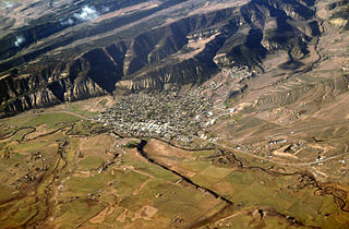
Montrose is a home rule municipality that is the county seat and the most populous municipality of Montrose County, Colorado, United States. The city population was 20,291 at the 2020 census, within a total area of 18.5 square miles. The main road that leads in and out of Montrose is U.S. Highway 50. The city is located in western Colorado, in the Uncompahgre Valley, and is an economic, labor, and transportation waypoint for the surrounding area. Montrose is the second-largest city in western Colorado, after Grand Junction.
Meeker is the Statutory Town in and the county seat of Rio Blanco County, Colorado, United States, that is the most populous municipality in the county. The town population was 2,374 at the 2020 United States Census.

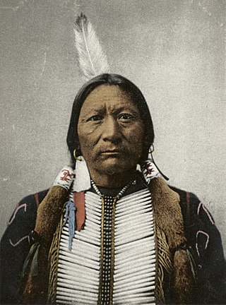
Ouray was a Native American chief of the Tabeguache (Uncompahgre) band of the Ute tribe, then located in western Colorado. Because of his leadership ability, Ouray was acknowledged by the United States government as a chief of the Ute and he traveled to Washington, D.C. to negotiate for the welfare of the Utes. Raised in the culturally diverse town of Taos, Ouray learned to speak many languages that helped him in the negotiations, which were complicated by the manipulation of his grief over his five-year-old son, abducted during an attack by the Sioux. Ouray met with Presidents Lincoln, Grant, and Hayes and was called the "man of peace" because he sought to make treaties with settlers and the government.

The Western Slope is a colloquial term generally understood to describe the part of the state of Colorado west of the Continental Divide. Bodies of water west of the Divide flow toward the Pacific Ocean; water that falls and flows east of the Divide heads east toward the Gulf of Mexico. The Western Slope encompasses about 33% of the state, but has just 10% of the state's residents. The eastern part of the state, including the San Luis Valley and the Front Range, is the more populous portion of the state.
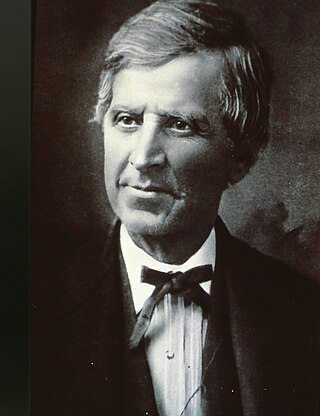
Nathan Cook Meeker was a 19th-century American journalist, homesteader, entrepreneur, and Indian agent for the federal government. He is noted for his founding in 1870 of the Union Colony, a cooperative agricultural colony in present-day Greeley, Colorado.

Ute are the indigenous, or Native American people, of the Ute tribe and culture among the Indigenous peoples of the Great Basin. They had lived in sovereignty in the regions of present-day Utah and Colorado.

The Ute Mountain Ute Tribe is one of three federally recognized tribes of the Ute Nation, and are mostly descendants of the historic Weeminuche Band who moved to the Southern Ute reservation in 1897. Their reservation is headquartered at Towaoc, Colorado on the Ute Mountain Ute Indian Reservation in southwestern Colorado, northwestern New Mexico and small sections of Utah.

Meeker Massacre, or Meeker Incident, White River War, Ute War, or the Ute Campaign), took place on September 29, 1879 in Colorado. Members of a band of Ute Indians attacked the Indian agency on their reservation, killing the Indian agent Nathan Meeker and his 10 male employees and taking five women and children as hostages. Meeker had been attempting to convert the Utes to Christianity, to make them farmers, and to prevent them from following their nomadic culture. On the same day as the massacre, United States Army forces were en route to the Agency from Fort Steele in Wyoming due to threats against Meeker. The Utes attacked U.S. troops led by Major Thomas T. Thornburgh at Milk Creek, 18 mi (29 km) north of present day Meeker, Colorado. They killed the major and 13 troops. Relief troops were called in and the Utes dispersed.
Charles Adams, born Karl Adam Schwanbeck, was a United States Army officer, US Indian agent, diplomat and businessman. In 1879 he secured the release of five hostages taken captive by the White River Utes after the Meeker Massacre, and held an official inquiry into their treatment. In 1880 he was appointed minister to Bolivia, where he served for two years. Returning to Colorado, he became involved in mining and water development.

The Ute Indian Tribe of the Uinta and Ouray Reservation is a Federally Recognized Tribe of Indians in northeastern Utah, United States. Three bands of Utes comprise the Ute Indian Tribe: the Whiteriver Band, the Uncompahgre Band and the Uintah Band. The Tribe has a membership of more than three thousand individuals, with over half living on the Uintah and Ouray Indian Reservation. The Ute Indian Tribe operates its own tribal government and oversees approximately 1.3 million acres of trust land which contains significant oil and gas deposits.

U.S. Route 50 (US 50) is a part of the U.S. Highway System that travels from West Sacramento, California, to Ocean City, Maryland. In the U.S. state of Colorado, US 50 is a major highway crossing through the lower midsection of the state. It connects the Western Slope with the lower Front Range and the Arkansas Valley. The highway serves the areas of Pueblo and Grand Junction as well as many other smaller areas along its corridor. The long-term project to widen the highway from two lanes to a four lane expressway between Grand Junction and Montrose was completed in January 2005. Only about 25% of the remainder of highway 50 in Colorado is four lane highway.
Sapiah, is also commonly known as Charles Buck and Buckskin Charley, was the leader of the Southern Ute tribe from about 1870 until his death in 1936. He led a group of Utes to rescue women and children from the White River Agency during the Meeker Massacre (1879) that resulted in the deaths of Nathan Meeker and his soldiers. The northern band of Utes were forced out of Colorado after the massacre.

Josephine Meeker, was a teacher and physician at the White River Indian Agency in Colorado Territory, where her father Nathan Meeker was the United States (US) agent. On September 29, 1879, he and 10 of his male employees were killed in a Ute attack, in what became known as the Meeker Massacre. Josephine, her mother Arvilla Meeker, and Mrs. Shadruck Price and her two children were taken captive and held hostage by the Ute tribe for 23 days.

Chipeta or White Singing Bird was a Native American leader, and the second wife of Chief Ouray of the Uncompahgre Ute tribe. Born a Kiowa Apache, she was raised by the Utes in what is now Conejos, Colorado. An advisor and confidant of her husband, Chipeta continued as a leader of her people after his death in 1880.
Ouray is an unincorporated village of the Uintah and Ouray Indian Reservation, located in west‑central Uintah County, Utah, United States.
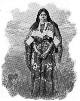
Shawsheen (Shoshine) otherwise known as She-towitch, or Susan, was a Native American woman who was a part of the Tabeguache (Uncompahgre) Ute tribe and sister to Chief Ouray. She is known for her capture by the Cheyenne and Arapaho in 1860 or 1861, her protection and care for Arvilla and Josephine Meeker during their captivity, as well as her role within the politics of her tribe as a female leader alongside her sister-in-law, Chipeta.

Nicaagat, also known as Chief, Captain and Ute Jack and Green Leaf. A Ute warrior and subchief, he led a Ute war party against the United States Army when it crossed Milk Creek onto the Ute reservation, which triggered the Battle of Milk Creek. Prior to the conflict, he had traveled to meet up with Major Thomas Tipton Thornburgh to learn of his intentions and warn him that crossing the Milk Creek onto the White River Ute reservation would be seen as an invasion and an act of war. When the army entered the reservation, a shooter from Nicaagat's band shot and killed Thornburgh.
