Prospect Valley, Colorado

Last updated
Prospect Valley, Colorado
Populated Place

Prospect Valley, Colorado.JPG

Prospect Valley, looking west along State Highway 52.
Coordinates: 40°04′25″N104°24′54″W / 40.07361°N 104.41500°W / 40.07361; -104.41500 Coordinates: 40°04′25″N104°24′54″W / 40.07361°N 104.41500°W / 40.07361; -104.41500
Country Flag of the United States.svg  United States
State Flag of Colorado.svg  Colorado
County Weld [1]
Elevation [1] 4,846 ft (1,477 m)
Time zone MST (UTC-7)
  Summer (DST) MDT (UTC-6)
ZIP code [2] 80643 (Keenesburg)
GNIS feature ID 180877

Prospect Valley is a populated place in Weld County, Colorado, United States. The Post Office at Keenesburg serves the Prospect Valley postal address. [2] SH 52 runs east and west through the community.
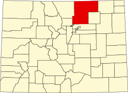
Weld County, Colorado County in the United States

Weld County is one of the 64 counties of the U.S. state of Colorado. As of the 2010 census, the population was 252,825. The county seat is Greeley.

Colorado State of the United States of America

Colorado is a state of the Western United States encompassing most of the southern Rocky Mountains as well as the northeastern portion of the Colorado Plateau and the western edge of the Great Plains. It is the 8th most extensive and 21st most populous U.S. state. The estimated population of Colorado was 5,695,564 on July 1, 2018, an increase of 13.25% since the 2010 United States Census.

Keenesburg, Colorado Statutory Town in Colorado, United States

The Town of Keenesburg is a Statutory Town in Weld County, Colorado, United States. The population was 1127 at the 2010 United States Census.

Geography

Prospect Valley is located at 40°4′25″N104°24′54″W / 40.07361°N 104.41500°W / 40.07361; -104.41500 (40.0735938, -104.4149556), [3] along State Highway 52, 11 miles east of Keenesburg.

Colorado State Highway 52 highway in Colorado

State Highway 52 is a 111 mi (178.6 km) long state highway in northeastern Colorado. The western terminus is at SH 119 near Niwot, and the eastern terminus is at SH 14 in Raymer.

Related Research Articles

Dacono, Colorado Home Rule Municipality in State of Colorado, United States

The City of Dacono is a Home Rule Municipality located in Weld County, Colorado, United States. The population was 4,152 at the 2010 census.

Gilcrest, Colorado Statutory Town in Colorado, United States

The Town of Gilcrest is a Statutory Town located in Weld County, Colorado, United States. The population was 1,162 at the 2000 census.

LaSalle, Colorado Statutory Town in Colorado, United States

The Town of LaSalle is a Statutory Town in Weld County, Colorado, United States. The town population was 1955 at the 2010 United States Census.

Mead, Colorado Statutory Town in Colorado, United States

The Town of Mead is a Statutory Town in Weld County, Colorado, United States. The town population was 3405 at the 2010 United States Census.

Platteville, Colorado Town in Colorado, United States

Platteville is a Statutory Town in Weld County, Colorado, United States. The population was 2,485 at the 2010 census. It is adjacent to Fort Vasquez on U.S. Highway 85.

Severance, Colorado Town in Colorado, United States

Severance is a Statutory Town in Weld County, Colorado, United States. The population was 3,165 at the 2010 census. The town is located on the Colorado Eastern Plains, northwest of Greeley, a crossroads of county roads.

New Haven Township, Shiawassee County, Michigan Township in Michigan, United States

New Haven Township is a civil township of Shiawassee County in the U.S. state of Michigan. The population was 1,293 at the 2000 census. The township was organized in 1848.

Hoyt, Colorado Unincorporated community in Colorado, United States

Hoyt is a small unincorporated community in Morgan County, Colorado, United States. The 1996 feet high Hoyt Radio Tower is located near Hoyt. The community was named after Dr. James A. Hoyt, an early settler.

Carr, Colorado Unincorporated community in State of Colorado, United States

Carr is an unincorporated community and U.S. Post Office in Weld County, Colorado, United States. The ZIP Code of the Carr Post Office is 80612. Some consider Carr a ghost town. Today, just a few old houses remain plus the school house and a few old store fronts. Aside from that there are scattered old foundations throughout the town. There are a few year-round residents but for the most part the town is abandoned.

Hereford, Colorado Unincorporated community in Colorado, United States

Hereford is an unincorporated community and a U.S. Post Office in Weld County, Colorado, United States. The Hereford Post Office has the ZIP Code 80732.

Maybell, Colorado Unincorporated community in Colorado, United States

Maybell is an unincorporated rural village, and namesake for a census-designated place (CDP), in Moffat County, Colorado, United States. It is located in the valley of the Yampa River along U.S. Highway 40. Craig is 30 miles (48 km) east along US 40, and Dinosaur is 57 miles (92 km) to the west. State Highway 318 leads northwest from Maybell 61 miles (98 km) to the Utah border, passing Browns Park National Wildlife Refuge. As of the 2010 census it had a population of 72.

Orchard, Colorado Unincorporated community in Colorado, United States

Orchard is an unincorporated community and a U.S. Post Office in Morgan County, Colorado, United States. The Orchard Post Office has the ZIP Code 80649.

Roggen, Colorado Unincorporated community in Colorado, United States

Roggen is an unincorporated community and a U.S. Post Office in Weld County, Colorado, United States. The Roggen Post Office has the ZIP Code 80652.

Rush, Colorado Unincorporated community in State of Colorado, United States

Rush is an unincorporated community and a U.S. Post Office located in El Paso County, Colorado, United States. The Rush Post Office has the ZIP Code 80833.

Wolcott, Colorado Census-designated place in Colorado, United States

Wolcott is a census-designated place (CDP) and a U.S. Post Office located in Eagle County, Colorado, United States. The population as of the 2010 census was 15. The Wolcott Post Office has the ZIP Code 81655.

Mesita, Colorado Unincorporated community in Colorado, United States

Mesita is an unincorporated community in Costilla County, Colorado, United States. The U.S. Post Office at San Luis now serves Mesita postal addresses.

Wattenburg, Colorado Unincorporated community in Colorado, United States

Wattenburg or Wattenberg is an unincorporated community located in Weld County, Colorado, United States. The U.S. Post Office at Fort Lupton now serves Wattenburg postal addresses.

Tampa, Colorado Unincorporated community in Colorado, United States

Tampa is an unincorporated community in Weld County, Colorado, United States. The rural community is served by an 80643 ZIP code.

Dove Valley, Colorado Human settlement in Colorado, United States of America

Dove Valley is a census-designated place (CDP) in Arapahoe County, Colorado, United States. The population as of the 2010 Census was 5,243. The headquarters and training camp of the Denver Broncos, as well as Centennial Airport, are located in Dove Valley. Air Methods and Key Lime Air have their corporate headquarters in the CDP as well.

References

  1. 1 2 "US Board on Geographic Names". United States Geological Survey. 2007-10-25. Retrieved 2008-01-31.
  2. 1 2 "ZIP Code Lookup" (JavaScript/HTML). United States Postal Service. January 2, 2007. Retrieved January 2, 2007.
  3. "US Gazetteer files: 2010, 2000, and 1990". United States Census Bureau. 2011-02-12. Retrieved 2011-04-23.